Old Maps of Bucktown, California
Explore 15 old maps of Bucktown, spanning from 1902 to today. These high-resolution historic maps reveal how streets, neighborhoods, landmarks, and natural features evolved over time — perfect for genealogy, metal detecting, research, and local history exploration.
What you can do with these maps:
- See how Bucktown changed over time: Compare historical maps to modern-day views to trace roads, homesites, rail lines & more.
- View detailed metadata: Each map includes creators, publishers, year, scale, and archive source.
- Overlay maps with satellite & LiDAR: Visualize the past alongside modern tools to explore terrain & human change.
- Trusted historical sources: Maps sourced from the USGS, Library of Congress, and other archives.
- Access maps your way: View online, download high-res files, or order prints for personal or research use.
Start exploring old maps of Bucktown to uncover forgotten places, hidden landmarks, and the deep history beneath your feet.
Bucktown, CA maps
(15)- 1902 Map of Napa
 1902 Napa1902 Print · USGSThe Napa Valley and Carquinez Strait are captured at the turn of the century, showing a landscape defined by maritime military posts and early vineyards. Genealogists and historians can trace the Mare Island Navy Yard, the Insane Asylum, and rail stops at Zinfandel and Rutherford.6 unique versions available
 - 1921 Map of Mt. Vaca
 1921 Mt. Vaca1921 Print · USGSFairfield and the surrounding highlands appear at a pivotal moment in the 1920s as early transportation networks began to define the region. Genealogists and historians can trace the early layout of Fairfield and locate remote settlements like Manka and Atlas.
 - 1942 Map of Mt. Vaca
 1942 Mt. Vaca1942 Print · USGSThe Vaca Mountains and eastern Napa County are captured during the early 1940s, showing a landscape of deep canyons and rising valley towns. Researchers can trace the rail corridors of the Southern Pacific near Fairfield or locate early water works like the Gordon Valley Dam.2 unique versions available
 - 1947 Map of Santa Rosa
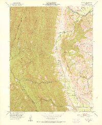
 1947 Santa Rosa1947 Print · USGSNorthern California in the late 1940s was a landscape of agricultural valleys and vital rail hubs. Trace the historic routes of the Northwestern Pacific through Healdsburg or explore the mid-century waterfronts of Vallejo and Benicia near Mare Island.
 - 1949 Map of Santa Rosa
 1949 Santa Rosa1949 Print · USGSThe North Bay and Wine Country appear here in the late 1940s, when the Northwestern Pacific RR still dominated regional transit. Genealogists and historians can trace old coastal outposts like Anchor Bay Settlement and the early layout of Santa Rosa.2 unique versions available
 - 1951 Map of Mt. Vaca, 1952 Print
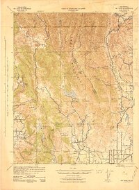
 1951 Mt. Vaca1952 Print · USGSSolano County rangelands and the steep ridges of the Vaca Mountains appear here as they were in the early fifties. Local historians and genealogists can trace family holdings like Pioneer Ranch or find the former site of the Rhine School (Abandoned) along Alamo Creek.3 unique versions available
 - 1951 Map of Mt. Vaca, 1959 Print
 1951 Mt. Vaca1959 Print · USGSNorthern California's agricultural valleys and ridges are captured here in the early fifties. Researchers can trace rural life through landmarks like Peña House, Mankas Corner, and schools such as Gordon Valley School.2 unique versions available
 - 1958 Map of Santa Rosa, 1968 Print
 1958 Santa Rosa1968 Print · USGSThe North Bay and Wine Country are captured in the mid-twentieth century as the region balanced its agricultural roots with a growing military and recreational footprint. Researchers can trace the Northwestern Pacific RR through the Russian River valley or locate landmarks like the Petaluma Adobe Historical Monument and The Geysers Resort.3 unique versions available
 - 1962 Map of Santa Rosa
 1962 Santa Rosa1962 Print · USGSThe North Bay and Wine Country were entering a period of significant growth in the early sixties, anchored by established rail corridors and coastal maritime commerce. Genealogists and historians can trace the development of Santa Rosa, locate the Mare Island Naval Shipyard, and follow the Northwestern Pacific RR through the Cotati Valley.
 - 1964 Map of Santa Rosa
 1964 Santa Rosa1964 Print · USGSThe North Bay and Wine Country appear in the mid-fifties during a period of significant military and educational growth. Trace old rail lines like the Northwestern Pacific RR and explore historic sites from Petaluma to the Benicia Arsenal.
 - 1983 Map of Napa
 1983 Napa1983 Print · USGSThe North Bay and wine country are captured in the early eighties as suburban growth began to surround traditional agricultural centers. Researchers can trace the rail corridors of the Northwestern Pacific Railroad, the grounds of Mare Island Naval Shipyard, and the reach of the San Andreas Rift Zone.
 - 2012 Map of Mount Vaca, 2012 Print
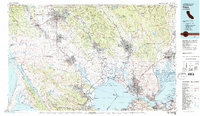
 2012 Mount Vaca2012 Print · USGSCovers Bucktown, including Vacaville, Solano County, and other nearby areas
 - 2015 Map of Mount Vaca, 2015 Print
 2015 Mount Vaca2015 Print · USGSCovers Bucktown, including Vacaville, Solano County, and other nearby areas
 - 2018 Map of Mount Vaca, 2018 Print
 2018 Mount Vaca2018 Print · USGSCovers Bucktown, including Vacaville, Solano County, and other nearby areas
 - 2021 Map of Mount Vaca, 2021 Print
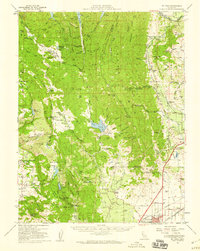
 2021 Mount Vaca2021 Print · USGSThe Vaca Mountains meet the Sacramento Valley floor in this recent survey of the Solano County foothills. Genealogists and hikers can trace the rural landscape around Bucktown, the heights of Mt Vaca, and the flight paths near Blake Sky Park.
End of results
Showing maps 1-15 of 15
Top cities near Bucktown
- Vallejo historical maps
- Fairfield historical maps
- Vacaville historical maps
- Suisun City historical maps
- Dixon historical maps
- American Canyon historical maps
See more
Frequently asked questions
- What are the different types of historical maps available for Bucktown?
- What is the oldest map of Bucktown?
- Where can I purchase historical maps of Bucktown for my home or office?
- Where can I download high-res historical maps of Bucktown?
- Are there historical topographic maps available for Bucktown?
- Is there historical aerial imagery available for Bucktown?
- Where are historical maps of Bucktown sourced from?