Old Maps of Vallejo, California for Academic Research
Study the evolution of Vallejo with 50 high-resolution historic maps. Whether you're teaching, researching, or modeling changes in land use, these maps provide essential visual documentation of urban, environmental, and geographic change.
- Analyze long-term change: Track patterns in development, transportation, and natural features.
- Ideal for environmental or urban studies: Support academic projects with primary historical map data.
- Use in the classroom or lab: Educators and researchers rely on these maps to bring historical context to life.
These maps are a powerful tool for teaching, research, and visualizing how Vallejo has changed over the decades.
Vallejo, CA maps
(50)- 1896 Map of Carquinez Strait, 1954 Print
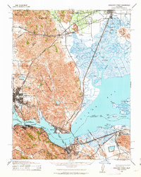
 1896 Carquinez Strait1954 Print · USGSThe industrial waterfront of the Carquinez Strait comes alive in the 1890s, where shipping channels meet the rails. Genealogists and historians can trace early bay settlements from the U.S. Arsenal at Benicia to the rail hubs of Vallejo and Martinez.
 - 1898 Map of Karquines
 1898 Karquines1898 Print · USGSThe Karquines Strait and Suisun Bay served as a bustling maritime and rail crossroads in the late nineteenth century. Researchers can trace the early layouts of Benicia, Vallejo, and Martinez, or locate vanished landmarks like Seal Bluff Landing and the U.S. Arsenal.
 - 1901 Map of Karquines
 1901 Karquines1901 Print · USGSNorthern California at the dawn of the twentieth century shows a landscape defined by the deep-water Karquines Strait and industrial rail hubs. Researchers can trace the waterfront activity of Benicia, Vallejo, and Martinez or the tidal marsh outposts at Drawbridge and Rush Landing.6 unique versions available
 - 1902 Map of Napa
 1902 Napa1902 Print · USGSThe Napa Valley and Carquinez Strait are captured at the turn of the century, showing a landscape defined by maritime military posts and early vineyards. Genealogists and historians can trace the Mare Island Navy Yard, the Insane Asylum, and rail stops at Zinfandel and Rutherford.6 unique versions available
 - 1916 Map of Mare Island
 1916 Mare Island1916 Print · USGSThe northern San Pablo Bay region comes alive in this survey, showcasing a landscape of tidal marshes and rail-driven growth during the mid-1910s. Researchers can trace the layout of the Mare Island Navy Yard, the remote rail stop at Wingo, and the rural classrooms of Fly School.4 unique versions available
 - 1940 Map of Carquinez Strait, 1963 Print
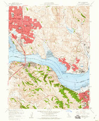
 1940 Carquinez Strait1963 Print · USGSThe industrial waterfronts of Solano and Contra Costa counties are captured here just before the mid-century boom. Genealogists and historians can trace the rail-and-water networks of Port Costa, Benicia, and Vallejo, or locate landmarks like the Carquinez Cem and the Benicia Auto Ferry.2 unique versions available
 - 1942 Map of Mare Island
 1942 Mare Island1942 Print · USGSThe northern reaches of San Pablo Bay come alive in this wartime survey, showing a landscape of vital naval yards and marshland agriculture. Genealogists and historians can trace rail depots like Napa Junction, rural landmarks like American Canyon School, and the industrial waterfronts of Vallejo and Oleum.
 - 1942 Map of Carquinez
 1942 Carquinez1942 Print · USGSThe industrial waterfront of the Carquinez Strait is captured here during the early years of the war. Researchers can trace the complex rail networks of the Southern Pacific and locate established neighborhoods in Vallejo, Benicia, and Crockett.
 - 1947 Map of Santa Rosa
 1947 Santa Rosa1947 Print · USGSNorthern California in the late 1940s was a landscape of agricultural valleys and vital rail hubs. Trace the historic routes of the Northwestern Pacific through Healdsburg or explore the mid-century waterfronts of Vallejo and Benicia near Mare Island.
 - 1949 Map of Santa Rosa
 1949 Santa Rosa1949 Print · USGSThe North Bay and Wine Country appear here in the late 1940s, when the Northwestern Pacific RR still dominated regional transit. Genealogists and historians can trace old coastal outposts like Anchor Bay Settlement and the early layout of Santa Rosa.2 unique versions available
 - 1949 Map of Cuttings Wharf, 1956 Print
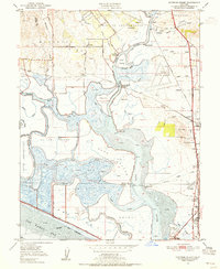 1949 Cuttings Wharf1956 Print · USGSThe Napa River delta in the late 1940s is a maze of tidal sloughs and growing railroad towns. Genealogists can trace family names at Cuttings Wharf, old rural schools like Los Amigos Sch, and early aviation sites like Vallejo Sky Harbor.8 unique versions available
 - 1949 Map of Mare Island, 1957 Print
 1949 Mare Island1957 Print · USGSThe Carquinez Strait and San Pablo Bay waterfronts are captured here during the post-war industrial peak. Researchers can trace historic shorelines and rail lines through Vallejo, the Mare Island Naval Reservation, and early industry at Oleum and Hercules.
 - 1950 Map of Benicia, 1956 Print
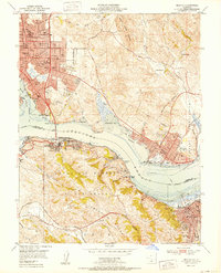
 1950 Benicia1956 Print · USGSThe Carquinez Strait bustles with industrial and maritime activity in the years following the war, from the refinery at Oleum to the rail hubs of Martinez. Genealogists and historians can trace old neighborhoods like Valona, find the Carquinez Cemetery, or locate the California Maritime Academy.
 - 1951 Map of Petaluma Point
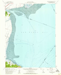
 1951 Petaluma Point1951 Print · USGSSan Pablo Bay and the Marin shoreline are captured here in the early fifties, detailing the transition from tidal marsh to inland hills. Trace the path of the Northwestern Pacific railroad past Rose or explore the historic site at China Camp.2 unique versions available
 - 1951 Map of Mare Island
 1951 Mare Island1951 Print · USGSThe industrial and naval might of the East Bay is on full display in the early fifties, centering on the massive Mare Island Naval Reservation. Trace the growth of Vallejo and the waterfront towns of Rodeo and Hercules along the Southern Pacific rail line.
 - 1951 Map of Cuttings Wharf
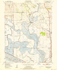 1951 Cuttings Wharf1951 Print · USGSThe Napa River delta and San Pablo Bay marshes come to life in this early 1950s survey of the California waterfront. Genealogists and historians can trace the development of Cuttings Wharf and Dutton Landing, or locate the Lachman Club among the sloughs.
 - 1951 Map of Sears Point, 1952 Print
 1951 Sears Point1952 Print · USGSThe northern edge of San Pablo Bay comes alive in the early fifties, showing a landscape of tidal sloughs and rail junctions. Genealogists and historians can trace the tracks of the Southern Pacific to settlements like Schellville, Wingo, and the Tule Vista School.5 unique versions available
 - 1951 Map of Cordelia, 1952 Print
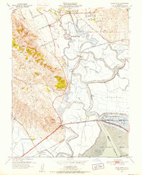
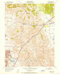 1951 Cordelia1952 Print · USGSNorth of Vallejo in the early fifties, this area shows a landscape of developing neighborhoods and heavy industry. Genealogists and historians can locate the Permanente Foundation Hospital, the St John Mine, and the rail junction at Cordelia.9 unique versions available
 - 1952 Map of Benicia
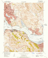
 1952 Benicia1952 Print · USGSThe Carquinez Strait corridor was a bustling industrial and maritime hub in the early fifties, bridging Solano and Contra Costa counties. Researchers can trace the waterfront rail lines of the Southern Pacific and locate landmarks like the California Maritime Academy and Nevada Dock.
 - 1958 Map of Santa Rosa, 1968 Print
 1958 Santa Rosa1968 Print · USGSThe North Bay and Wine Country are captured in the mid-twentieth century as the region balanced its agricultural roots with a growing military and recreational footprint. Researchers can trace the Northwestern Pacific RR through the Russian River valley or locate landmarks like the Petaluma Adobe Historical Monument and The Geysers Resort.3 unique versions available
 - 1959 Map of Petaluma Point, 1960 Print
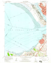
 1959 Petaluma Point1960 Print · USGSThe northern reaches of San Pablo Bay are captured here in the late fifties, a period when maritime navigation and military presence shaped the Marin shoreline. Researchers can trace the layout of Hamilton Air Force Base and the rail path of the Northwestern Pacific near China Camp.6 unique versions available
 - 1959 Map of Benicia, 1960 Print
 1959 Benicia1960 Print · USGSThe Carquinez Strait corridor comes alive in the late fifties as industrial waterfronts and new suburban tracts transform the Solano and Contra Costa shoreline. Researchers can trace the legacy of the Benicia Arsenal, the Nevada Dock, and the historic Benicia Capitol State Historical Mon.8 unique versions available
 - 1959 Map of Mare Island, 1960 Print
 1959 Mare Island1960 Print · USGSCoastal Solano and Contra Costa Counties are shown at a peak of industrial and naval activity during the late fifties. Researchers can trace the massive Mare Island Naval Reservation or locate local landmarks like St Vincents Sch and the Old Hillside Cem.5 unique versions available
 - 1962 Map of Santa Rosa
 1962 Santa Rosa1962 Print · USGSThe North Bay and Wine Country were entering a period of significant growth in the early sixties, anchored by established rail corridors and coastal maritime commerce. Genealogists and historians can trace the development of Santa Rosa, locate the Mare Island Naval Shipyard, and follow the Northwestern Pacific RR through the Cotati Valley.
 - 1964 Map of Santa Rosa
 1964 Santa Rosa1964 Print · USGSThe North Bay and Wine Country appear in the mid-fifties during a period of significant military and educational growth. Trace old rail lines like the Northwestern Pacific RR and explore historic sites from Petaluma to the Benicia Arsenal.
Showing maps 1-25 of 50
Top cities near Vallejo
- San Francisco historical maps
- Concord historical maps
- Berkeley historical maps
- Fairfield historical maps
- Richmond historical maps
- Napa historical maps
See more
Top neighborhoods of Vallejo
- Carquinez Heights historical maps
- South Vallejo historical maps
- Guadalcanal Village historical maps
- Chabot Terrace historical maps
- Harry Floyd Terrace historical maps
- Flosden Acres historical maps
See more
Frequently asked questions
- What are the different types of historical maps available for Vallejo?
- What is the oldest map of Vallejo?
- Where can I purchase historical maps of Vallejo for my home or office?
- Where can I download high-res historical maps of Vallejo?
- Are there historical topographic maps available for Vallejo?
- Is there historical aerial imagery available for Vallejo?
- Where are historical maps of Vallejo sourced from?