1990s Maps of Nervo, California
Explore 2 historic maps of Nervo from the 1990s. These maps offer a rare glimpse into what life looked like during the 1990s — showing old roads, neighborhoods, homes, and landmarks that have changed or disappeared over time.
Whether you're researching your family's past, planning a metal detecting trip, or studying how Nervo's landscape evolved across the 1990s, these high-resolution maps are a powerful tool for exploring the history of this region.
- Focus on a specific era: All maps on this page are from the 1990s, giving you a focused view of this time period.
- See what’s changed: Compare century-old streets, trails, and buildings to today's modern landscape using overlays and satellite layers.
- Research with precision: Use these maps for genealogy, historical research, land use analysis, or educational projects.
- View, download, or print: Maps are fully viewable online in high resolution, and can be downloaded or printed for your own records.
Start exploring Nervo's history through authentic maps from the 1990s. This is your window into the past.
Nervo, CA maps
(2)- 1993 Map of Geyserville
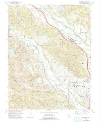 1993 Geyserville1993 Print · USGSNorthern Sonoma County in the early 1990s reveals a landscape of river-valley agriculture and hillside ridges. Genealogists and researchers can trace local landmarks like Olive Hill Cemetery, the Manzanita Sch, and the community of Geyserville.
 - 1997 Map of Geyserville, 1998 Print
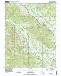 1997 Geyserville1998 Print · USGSIn the late 1990s, the Russian River corridor near Geyserville was defined by its valley agriculture and mountain ridges. Researchers can locate family landmarks like Olive Hill Cemetery, the Grange Hall, and small settlements such as Chianti and Nervo.
End of results
Showing maps 1-2 of 2
Top cities near Nervo
- Santa Rosa historical maps
- Windsor historical maps
- Villa Grande historical maps
- Healdsburg historical maps
- Cloverdale historical maps
- Cobb historical maps
See more
Frequently asked questions
- What are the different types of historical maps available for Nervo?
- What is the oldest map of Nervo?
- Where can I purchase historical maps of Nervo for my home or office?
- Where can I download high-res historical maps of Nervo?
- Are there historical topographic maps available for Nervo?
- Is there historical aerial imagery available for Nervo?
- Where are historical maps of Nervo sourced from?