1900-1909 Maps of Sutter County, California
Explore 3 historic maps of Sutter County from 1900-1909. These maps offer a rare glimpse into what life looked like during the 1900s — showing old roads, neighborhoods, homes, and landmarks that have changed or disappeared over time.
Whether you're researching your family's past, planning a metal detecting trip, or studying how Sutter County's landscape evolved across the 1900s, these high-resolution maps are a powerful tool for exploring the history of this region.
- Focus on a specific era: All maps on this page are from the 1900s, giving you a focused view of this time period.
- See what’s changed: Compare century-old streets, trails, and buildings to today's modern landscape using overlays and satellite layers.
- Research with precision: Use these maps for genealogy, historical research, land use analysis, or educational projects.
- View, download, or print: Maps are fully viewable online in high resolution, and can be downloaded or printed for your own records.
Start exploring Sutter County's history through authentic maps from the 1900s. This is your window into the past.
Sutter County, CA maps
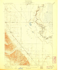
(3)- 1902 Map of Fairoaks
 1902 Fairoaks1902 Print · USGSSacramento and its surrounding ranchlands were undergoing a rapid rail-driven transformation at the start of the century. You can trace the early street grids of Oak Park and Highland Park or locate vanished stops like Twelvemile House and Walsh Station.2 unique versions available
 - 1907 Map of Dunnigan
 1907 Dunnigan1907 Print · USGSThe Sacramento Valley in the early 1900s is defined by its busy river landings and the emerging rail corridor. Genealogists can trace family footprints at Zamora Blacks Station P O or follow the river to Cranmore Landing and Derby Camp.3 unique versions available
 - 1907 Map of Davisville
 1907 Davisville1907 Print · USGSYolo and Sacramento counties are captured here at a pivot point for river transit and rail growth. Researchers can trace early rural life via the Lisbon School, Taylor Monument Datey's Ferry, and the original footprint of Davisville.2 unique versions available
End of results
Showing maps 1-3 of 3
Top cities of Sutter County
Frequently asked questions
- What are the different types of historical maps available for Sutter County?
- What is the oldest map of Sutter County?
- Where can I purchase historical maps of Sutter County for my home or office?
- Where can I download high-res historical maps of Sutter County?
- Are there historical topographic maps available for Sutter County?
- Is there historical aerial imagery available for Sutter County?
- Where are historical maps of Sutter County sourced from?