1950s Maps of Sutter County, California
Explore 37 historic maps of Sutter County from the 1950s. These maps offer a rare glimpse into what life looked like during the 1950s — showing old roads, neighborhoods, homes, and landmarks that have changed or disappeared over time.
Whether you're researching your family's past, planning a metal detecting trip, or studying how Sutter County's landscape evolved across the 1950s, these high-resolution maps are a powerful tool for exploring the history of this region.
- Focus on a specific era: All maps on this page are from the 1950s, giving you a focused view of this time period.
- See what’s changed: Compare century-old streets, trails, and buildings to today's modern landscape using overlays and satellite layers.
- Research with precision: Use these maps for genealogy, historical research, land use analysis, or educational projects.
- View, download, or print: Maps are fully viewable online in high resolution, and can be downloaded or printed for your own records.
Start exploring Sutter County's history through authentic maps from the 1950s. This is your window into the past.
Sutter County, CA maps
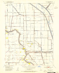
(37)- 1950 Map of Rio Linda, 1955 Print
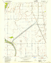
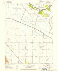
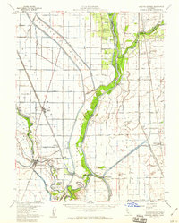
 1950 Rio Linda1955 Print · USGSNorthern Sacramento at mid-century reveals the growth of Rio Linda and the strategic footprint of the military. Trace the 1950s landscape of McClellan Field, the campus of Grant Tech College, and the rail lines of the Sacramento Northern RR.
 - 1950 Map of Taylor Monument, 1960 Print
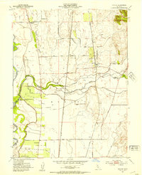
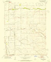
 1950 Taylor Monument1960 Print · USGSThe Sacramento River delta and American Basin are shown here in the mid-century, defined by an intricate system of levees and canals. You can trace the Sacramento Northern rail line and locate rural landmarks like American Basin School and Kiesel.
 - 1951 Map of Taylor Monument
 1951 Taylor Monument1951 Print · USGSThe Sacramento River delta and American Basin are shown at mid-century during a period of significant agricultural and infrastructure development. Trace local family history at Monument Sch, follow the Sacramento Northern rail, or locate the site of Radio Sta KCRA.
 - 1951 Map of Rio Linda
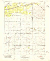
 1951 Rio Linda1951 Print · USGSSacramento County's northern outskirts undergo a period of post-war growth as military installations and suburban neighborhoods expand into the valley. Researchers can trace the development of McClellan Field, find family roots at Grant Mem Park, or follow the historic Sacramento Northern rail line.
 - 1952 Map of Sutter Causeway
 1952 Sutter Causeway1952 Print · USGSAgricultural life in the Central Valley centered on the complex water management of the early fifties. Genealogists and historians can trace the tracks of the Southern Pacific (Reclamation) through Subaco or locate family holdings along Sutter Causeway and Sutter By-Pass.4 unique versions available
 - 1952 Map of Gilsizer Slough, 1953 Print
 1952 Gilsizer Slough1953 Print · USGSSutter County's agricultural heartland is captured here in the early fifties, showing a landscape defined by drainage canals and orchard grids. Researchers can locate vanished rural landmarks like Lincoln Sch, Oswald, and the KUBA Radio Towers among the many family-named roads.3 unique versions available
 - 1952 Map of Verona, 1953 Print
 1952 Verona1953 Print · USGSThe confluence of the Sacramento and Feather Rivers in the early 1950s reveals a landscape shaped by levees, canals, and river landings. Genealogists and researchers can trace rural life at Pleasant Grove Sch or locate the historic river hubs at Verona and Vernon Landing.3 unique versions available
 - 1952 Map of Kirkville, 1953 Print
 1952 Kirkville1953 Print · USGSThe Sacramento River corridor in the early fifties is mapped here in detail, showing a landscape defined by industrial pumping and river landings. Genealogists and historians can trace family-named sites like Poffenbergers Landing, Tyndall Mound, and the settlement of Cranmore.3 unique versions available
 - 1952 Map of Olivehurst, 1953 Print
 1952 Olivehurst1953 Print · USGSThe Yuba and Feather River floodplains in the early fifties show a fascinating mix of orchard land, rail corridors, and new suburban growth. Genealogists can locate family landmarks like Boardman Ranch or trace the early foundations of Ella Sch and Olivehurst School.5 unique versions available
 - 1952 Map of Nicolaus, 1953 Print
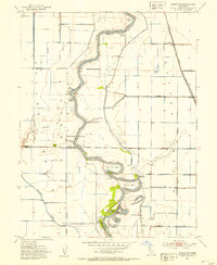
 1952 Nicolaus1953 Print · USGSIn the early 1950s, the Sutter County river basin was a vital hub of rail and agriculture at the junction of two major rivers. Trace local roots through the Nicolaus Cem, Fairview Church, and the many tracks of the Southern Pacific and Sacramento Northern railroads.4 unique versions available
 - 1952 Map of Eldorado Bend, 1953 Print
 1952 Eldorado Bend1953 Print · USGSThe Sacramento River winds through the fertile Central Valley in the early fifties, revealing an engineered landscape of levees and canals. Genealogists and local historians can trace the Southern Pacific rail line to Dufour or locate Marys Cemetery near the center of the basin.4 unique versions available
 - 1952 Map of Sanborn Slough, 1953 Print
 1952 Sanborn Slough1953 Print · USGSThe lowlands of the Sacramento Valley are captured here in the early fifties, showing a landscape defined by seasonal marshes and hunting heritage. Local historians can trace the intricate network of the Butte Sink, the site of the Harmony Sch (Aban'd), and numerous sportsmen's landmarks like the Tule Goose Gun Club.5 unique versions available
 - 1952 Map of Gridley, 1953 Print
 1952 Gridley1953 Print · USGSThe fertile plains between Gridley and Live Oak are shown in high detail during the early fifties, a time of peak agricultural production in the Sacramento Valley. Genealogists and local historians can locate many rural landmarks including the Live Oak Cemetery, the County Fairground, and the West Liberty School.4 unique versions available
 - 1952 Map of Yuba City, 1954 Print
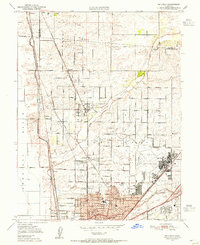
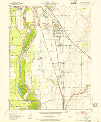
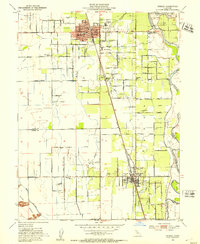
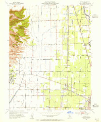
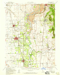
 1952 Yuba City1954 Print · USGSMarysville and Yuba City are captured at their mid-century confluence during an era of significant expansion and industrial activity. Genealogists can locate family landmarks like Marysville Cemetery, while historians can trace the SOUTHERN PACIFIC rails and the Dantoni agricultural colony.5 unique versions available
 - 1952 Map of Tisdale Weir, 1954 Print
 1952 Tisdale Weir1954 Print · USGSThe Sacramento Valley in the early fifties reveals a highly engineered landscape of flood bypasses and river landings. Genealogists and local historians can trace rural school sites like Winship School and historical river crossings such as Eddys Ferry.3 unique versions available
 - 1952 Map of Honcut, 1954 Print
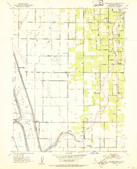
 1952 Honcut1954 Print · USGSThe northern Sacramento Valley's agricultural heartland is documented here during the mid-century expansion of its orchard and rail networks. Researchers can trace historic boundaries and family-named landmarks like Robinsons Corner, La Finca Orchards, and the junction of the Western Pacific railroad.3 unique versions available
 - 1952 Map of Meridian, 1955 Print
 1952 Meridian1955 Print · USGSThe Sacramento River valley in the early fifties shows a landscape shaped by flood control and rail transport. Genealogists and historians can trace family-named sites like Arbee, locate the Cemetery near Meridian, and study the reach of the Southern Pacific.4 unique versions available
 - 1952 Map of Sutter, 1955 Print
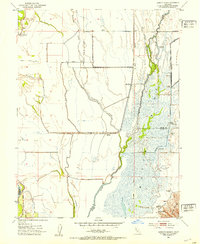
 1952 Sutter1955 Print · USGSThe Sacramento Valley's agricultural heartland is captured here in the early fifties, where the volcanic Sutter Buttes meet a network of canals and rail lines. Researchers can locate family landmarks such as Franklin Home Site Church, the rural Encinal Sch, and the busy Packing Plant near the Feather River.4 unique versions available
 - 1952 Map of Knights Landing, 1959 Print
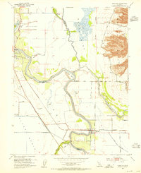
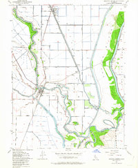
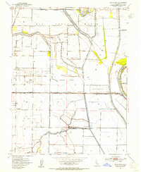
 1952 Knights Landing1959 Print · USGSMid-century Sutter and Yolo counties are defined here by a complex network of levees, bypasses, and river bends. Genealogists and local historians can trace family-named sites like Fairview Cemetery and Wilson School alongside the bustling rail lines of the Southern Pacific.2 unique versions available
 - 1952 Map of Gridley, 1959 Print
 1952 Gridley1959 Print · USGSThe agricultural heart of the Sacramento Valley is captured here in the early fifties, showing the intricate canal networks and rail lines of the day. Researchers can trace family roots through the Onstott Ranch, Lone Tree School, and the Gridley-Biggs Cem.2 unique versions available
 - 1952 Map of Marysville, 1959 Print
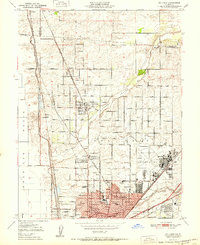
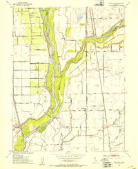
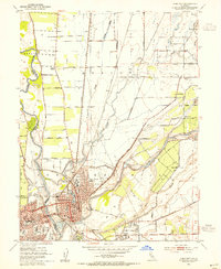
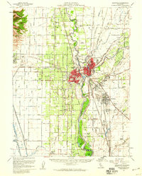 1952 Marysville1959 Print · USGSThe Yuba-Sutter region at mid-century reveals a landscape of river-driven agriculture and expanding rail hubs. Researchers can trace the development of Yuba City and Marysville alongside rural landmarks like Plumas Lake and the Sutter Nat Wildlife Refuge.3 unique versions available
 - 1952 Map of Knights Landing, 1964 Print
 1952 Knights Landing1964 Print · USGSThe riverfront and rail junction of Knights Landing are captured here in the early fifties, showing the intricate water management of the Sacramento Valley. Genealogists and historians can trace family-named landmarks like McGriff Lakes, the Knights Landing School, and the local cemetery.5 unique versions available
 - 1953 Map of Pleasant Grove, 1954 Print
 1953 Pleasant Grove1954 Print · USGSThe Sutter and Placer county borderlands are shown here in the mid-twentieth century as a productive landscape of ranches and rail lines. Genealogists and historians can trace family locations near Pleasant Grove, the Alpha Sch, or the small station at Sankey.2 unique versions available
 - 1953 Map of Sheridan, 1954 Print
 1953 Sheridan1954 Print · USGSSheridan and the surrounding ranchlands are captured here in the early 1950s, showing the intersection of the Central Valley’s water and rail networks. Researchers can trace historic land boundaries like the Johnson Grant Rancho and old infrastructure along the Southern Pacific railroad.4 unique versions available
 - 1953 Map of Grays Bend, 1954 Print
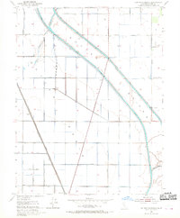
 1953 Grays Bend1954 Print · USGSThe Yolo County floodplains in the early fifties reveal a landscape defined by massive water projects and the Sacramento river-and-rail economy. Researchers can trace the path of the Elkhorn Ferry, the Willow Spring Union School, and the industrial Beet Pulp Silo.4 unique versions available
Showing maps 1-25 of 37
Top cities of Sutter County
Frequently asked questions
- What are the different types of historical maps available for Sutter County?
- What is the oldest map of Sutter County?
- Where can I purchase historical maps of Sutter County for my home or office?
- Where can I download high-res historical maps of Sutter County?
- Are there historical topographic maps available for Sutter County?
- Is there historical aerial imagery available for Sutter County?
- Where are historical maps of Sutter County sourced from?