Old Maps of Kirkwood, California for Academic Research
Study the evolution of Kirkwood with 12 high-resolution historic maps. Whether you're teaching, researching, or modeling changes in land use, these maps provide essential visual documentation of urban, environmental, and geographic change.
- Analyze long-term change: Track patterns in development, transportation, and natural features.
- Ideal for environmental or urban studies: Support academic projects with primary historical map data.
- Use in the classroom or lab: Educators and researchers rely on these maps to bring historical context to life.
These maps are a powerful tool for teaching, research, and visualizing how Kirkwood has changed over the decades.
Kirkwood, CA maps
(12)- 1904 Map of Vina
 1904 Vina1904 Print · USGSThe Sacramento Valley comes alive in this early century study of the river corridor between Tehama and Butte counties. Trace the rail-and-river economy through the Winery at Vina, the Squaw Hill Ferry, and the planned Lemon Home Colony.3 unique versions available
 - 1914 Map of Kirkwood
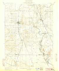
 1914 Kirkwood1914 Print · USGSThe northern Sacramento Valley's agricultural transition is on display here in the years before the Great War. Genealogists and researchers can trace early rail sidings and water networks like Kirkwood, Malton, and the Lemon Home Colony Canal.
 - 1949 Map of Kirkwood, 1968 Print
 1949 Kirkwood1968 Print · USGSThe Tehama and Glenn county border in the late 1940s was defined by the Southern Pacific rail line and a complex network of irrigation canals. Genealogists can locate family sites near Kirkwood Cem, Lake School, and the Union High Sch in Orland.3 unique versions available
 - 1950 Map of Kirkwood
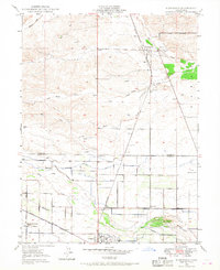
 1950 Kirkwood1950 Print · USGSThe Sacramento Valley at the mid-century shows a landscape of growing irrigation and established rail towns along the Southern Pacific line. Genealogists and local historians can trace family roots through sites like Kirkwood Cem, Lake School, and the Masonic Cem.
 - 1951 Map of Corning, 1959 Print
 1951 Corning1959 Print · USGSThe Sacramento Valley in the early fifties shows a region defined by its river landings and expanding rail infrastructure. Researchers can locate family-named schools and vanished river sites such as McIntosh Landing, Kirkwood Cemetery, and Union High School.3 unique versions available
 - 1957 Map of Ukiah, 1966 Print
 1957 Ukiah1966 Print · USGSNorthern California's diverse terrain comes into focus in the mid-1950s, from the rugged timberlands of the Jackson State Forest to the productive Sacramento Valley. Genealogists and historians can trace the rail lines of the Northwestern Pacific or locate early valley settlements like Arbuckle and Paskenta.3 unique versions available
 - 1960 Map of Ukiah
 1960 Ukiah1960 Print · USGSNorthern California during the late fifties reveals a landscape of deep timber forests and valley agriculture before modern expansion. Trace the historic rail lines of the California Western RR and the Northwestern Pacific RR through settlements like Fort Bragg and Ukiah.2 unique versions available
 - 1987 Map of Willows, 1988 Print
 1987 Willows1988 Print · USGSThe northern Sacramento Valley meets the Coast Range in the late eighties, showing a landscape defined by water and transit. Researchers can trace the Southern Pacific railroad past Artois and Corning, or locate family-named landmarks like Larkins Childrens Rancho and Snaden Island.2 unique versions available
 - 2012 Map of Kirkwood, 2012 Print
 2012 Kirkwood2012 Print · USGSCovers Kirkwood, including Wyo, Cory, and other nearby areas
 - 2015 Map of Kirkwood, 2015 Print
 2015 Kirkwood2015 Print · USGSCovers Kirkwood, including Wyo, Cory, and other nearby areas
 - 2018 Map of Kirkwood, 2018 Print
 2018 Kirkwood2018 Print · USGSCovers Kirkwood, including Wyo, Cory, and other nearby areas
 - 2022 Map of Kirkwood, 2022 Print
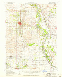
 2022 Kirkwood2022 Print · USGSThe northern Sacramento Valley comes into focus here, showing the agricultural corridor between Orland and Kirkwood. Researchers can trace old property lines and water rights near the Lemon Home Colony Canal, Kirkwood Cem, and the small settlement of Wyo.
End of results
Showing maps 1-12 of 12
Top cities near Kirkwood
- Corning historical maps
- Los Molinos historical maps
- Rancho Tehama Reserve historical maps
- Tehama historical maps
- Vina historical maps
Frequently asked questions
- What are the different types of historical maps available for Kirkwood?
- What is the oldest map of Kirkwood?
- Where can I purchase historical maps of Kirkwood for my home or office?
- Where can I download high-res historical maps of Kirkwood?
- Are there historical topographic maps available for Kirkwood?
- Is there historical aerial imagery available for Kirkwood?
- Where are historical maps of Kirkwood sourced from?