1940s Maps of Oxnard, California
Explore 7 historic maps of Oxnard from the 1940s. These maps offer a rare glimpse into what life looked like during the 1940s — showing old roads, neighborhoods, homes, and landmarks that have changed or disappeared over time.
Whether you're researching your family's past, planning a metal detecting trip, or studying how Oxnard's landscape evolved across the 1940s, these high-resolution maps are a powerful tool for exploring the history of this region.
- Focus on a specific era: All maps on this page are from the 1940s, giving you a focused view of this time period.
- See what’s changed: Compare century-old streets, trails, and buildings to today's modern landscape using overlays and satellite layers.
- Research with precision: Use these maps for genealogy, historical research, land use analysis, or educational projects.
- View, download, or print: Maps are fully viewable online in high resolution, and can be downloaded or printed for your own records.
Start exploring Oxnard's history through authentic maps from the 1940s. This is your window into the past.
Oxnard, CA maps
(7)- 1942 Map of Santa Paula
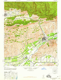
 1942 Santa Paula1942 Print · USGSVentura County's fertile valleys and burgeoning oil industry are documented here during the early war years. Genealogists and historians can trace the rail-linked settlements of Saticoy and Santa Paula, find rural schoolhouses like Center Sch, and locate industrial sites like the Timber Canyon Oil Co.
 - 1942 Map of Hueneme
 1942 Hueneme1942 Print · USGSVentura County's coastal plain and agricultural heartland are shown here at the start of the 1940s. Genealogists and historians can trace early residential tracts at Silver Strand, the wartime growth of Port Hueneme, and the layout of Camarillo State Hospital.
 - 1943 Map of Hueneme
 1943 Hueneme1943 Print · USGSVentura County's coastal plains and ranch lands are captured here during the early 1940s. Genealogists and researchers can trace the rural school districts of Springville Sch, the vast grounds of Camarillo State Hospital, and early seaside developments like Silver Strand.
 - 1947 Map of Santa Paula
 1947 Santa Paula1947 Print · USGSVentura County agriculture and industry meet along the Santa Clara River just after the war. Local researchers can trace the Southern Pacific rail line between Santa Paula and Saticoy, or find petroleum history at the Texaco Oil Co site.
 - 1949 Map of Los Angeles
 1949 Los Angeles1949 Print · USGSSouthern California and the South Coast appear at the onset of the post-war boom, from the Channel Islands to the Mojave Desert. Trace early aviation sites like Lockheed Air Terminal and mining history at the Redrock Quicksilver Mine and Redrover Mine.2 unique versions available
 - 1949 Map of Oxnard, 1956 Print
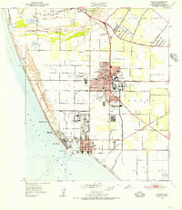 1949 Oxnard1956 Print · USGSThe Oxnard plain in the late 1940s reveals a unique landscape where coastal naval operations met a thriving agricultural and rail economy. Genealogists and historians can locate family-named landmarks like the Old Olivas Adobe and trace early schools such as Ocean View Sch and Colonia Sch.4 unique versions available
 - 1949 Map of Point Mugu, 1957 Print
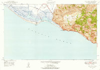 1949 Point Mugu1957 Print · USGSThe Ventura coast meets the high ridges of the Santa Monica Mountains in the late 1940s, just as military infrastructure began to define the shoreline. Researchers can trace the early footprint of the Naval Reservation and the original path of the Roosevelt Highway past Point Mugu.6 unique versions available
End of results
Showing maps 1-7 of 7
Top cities near Oxnard
- Thousand Oaks historical maps
- Ventura historical maps
- Camarillo historical maps
- Santa Paula historical maps
- Port Hueneme historical maps
Top neighborhoods of Oxnard
- Oxnard Shores historical maps
- Owl Mobile Manor historical maps
- El Rio historical maps
- The Westerlies historical maps
Frequently asked questions
- What are the different types of historical maps available for Oxnard?
- What is the oldest map of Oxnard?
- Where can I purchase historical maps of Oxnard for my home or office?
- Where can I download high-res historical maps of Oxnard?
- Are there historical topographic maps available for Oxnard?
- Is there historical aerial imagery available for Oxnard?
- Where are historical maps of Oxnard sourced from?