1950s Maps of Oxnard, California
Explore 7 historic maps of Oxnard from the 1950s. These maps offer a rare glimpse into what life looked like during the 1950s — showing old roads, neighborhoods, homes, and landmarks that have changed or disappeared over time.
Whether you're researching your family's past, planning a metal detecting trip, or studying how Oxnard's landscape evolved across the 1950s, these high-resolution maps are a powerful tool for exploring the history of this region.
- Focus on a specific era: All maps on this page are from the 1950s, giving you a focused view of this time period.
- See what’s changed: Compare century-old streets, trails, and buildings to today's modern landscape using overlays and satellite layers.
- Research with precision: Use these maps for genealogy, historical research, land use analysis, or educational projects.
- View, download, or print: Maps are fully viewable online in high resolution, and can be downloaded or printed for your own records.
Start exploring Oxnard's history through authentic maps from the 1950s. This is your window into the past.
Oxnard, CA maps
(7)- 1950 Map of Point Mugu
 1950 Point Mugu1950 Print · USGSCoastal Ventura County during the post-war era reveals a shoreline balanced between military expansion and the canyons of the Santa Monica Mountains. Collectors and local historians can trace the early layout of the Point Mugu Naval Reservation and follow the path of the Roosevelt Highway.
 - 1950 Map of Camarillo, 1956 Print
 1950 Camarillo1956 Print · USGSVentura County at the dawn of the fifties reveals a thriving agricultural valley transitioning into a regional hub. Genealogists and historians can trace the footprint of Camarillo, the sprawling Camarillo State Hospital, and family landmarks like Broome Ranch.7 unique versions available
 - 1951 Map of Oxnard
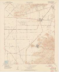
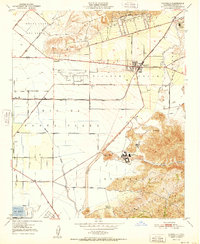
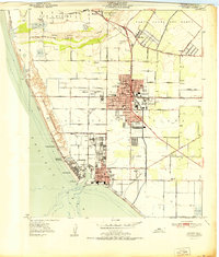 1951 Oxnard1951 Print · USGSVentura County's coastal plain was a hub of military and agricultural activity in the early fifties. Genealogists and local historians can trace family-named sites like the Old Olivas Adobe or locate legacy burials at the Japanese Cem and Masonic Cem.
 - 1951 Map of Camarillo
 1951 Camarillo1951 Print · USGSVentura County's fertile coastal valleys are captured here in the early fifties during a period of significant institutional expansion. Researchers can trace the layout of the Camarillo State Hospital, the grounds of St Johns Seminary, and early rail operations along the Southern Pacific.
 - 1951 Map of Saticoy, 1952 Print
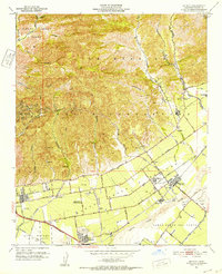 1951 Saticoy1952 Print · USGSVentura County during the early fifties reveals a landscape of expanding citrus groves and growing petroleum fields. Genealogists and historians can trace the foundations of Montalvo, locate the Ivy Lawn Cemetery, and find early landmarks like the Drive-in Theatre.5 unique versions available
 - 1955 Map of Los Angeles
 1955 Los Angeles1955 Print · USGSThe mid-century transformation of Southern California comes into focus as the urban sprawl of Los Angeles meets the wilderness of the Santa Monica Mountains. Researchers can trace the development of post-war suburbs alongside historic landmarks like the Santa Barbara Lighthouse and early industrial sites such as the Good Luck Mine.
 - 1959 Map of Los Angeles
 1959 Los Angeles1959 Print · USGSCoastal California and the high desert met in a period of booming growth after the war. Researchers can trace early aviation and military history at the Point Mugu Air Missile Test Ctr or locate desert mining sites like the Double Eagle Mine.3 unique versions available
End of results
Showing maps 1-7 of 7
Top cities near Oxnard
- Thousand Oaks historical maps
- Ventura historical maps
- Camarillo historical maps
- Santa Paula historical maps
- Port Hueneme historical maps
Top neighborhoods of Oxnard
- Oxnard Shores historical maps
- Owl Mobile Manor historical maps
- El Rio historical maps
- The Westerlies historical maps
Frequently asked questions
- What are the different types of historical maps available for Oxnard?
- What is the oldest map of Oxnard?
- Where can I purchase historical maps of Oxnard for my home or office?
- Where can I download high-res historical maps of Oxnard?
- Are there historical topographic maps available for Oxnard?
- Is there historical aerial imagery available for Oxnard?
- Where are historical maps of Oxnard sourced from?