1940s Maps of Simi Valley, California
Explore 8 historic maps of Simi Valley from the 1940s. These maps offer a rare glimpse into what life looked like during the 1940s — showing old roads, neighborhoods, homes, and landmarks that have changed or disappeared over time.
Whether you're researching your family's past, planning a metal detecting trip, or studying how Simi Valley's landscape evolved across the 1940s, these high-resolution maps are a powerful tool for exploring the history of this region.
- Focus on a specific era: All maps on this page are from the 1940s, giving you a focused view of this time period.
- See what’s changed: Compare century-old streets, trails, and buildings to today's modern landscape using overlays and satellite layers.
- Research with precision: Use these maps for genealogy, historical research, land use analysis, or educational projects.
- View, download, or print: Maps are fully viewable online in high resolution, and can be downloaded or printed for your own records.
Start exploring Simi Valley's history through authentic maps from the 1940s. This is your window into the past.
Simi Valley, CA maps
(8)- 1940 Map of Pico
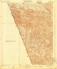 1940 Pico1940 Print · USGSThe northern reaches of the Santa Susana Mountains appear here in the late 1930s, showing the complex canyons of the Los Angeles and Ventura county line. Researchers can trace early settlements and remote outposts like Pico and La Quinta or locate high-country landmarks such as Oat Mtn Lookout.
 - 1940 Map of Chatsworth
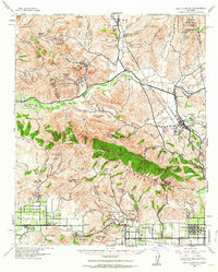
 1940 Chatsworth1940 Print · USGSThe northwest San Fernando Valley appears in the 1940s as a land of iconic movie ranches and burgeoning citrus communities. Researchers can trace the early footprints of Chatsworth and Canoga Park or locate family-named sites like Iverson Ranch and Brandies Ranch.
 - 1941 Map of Piru, 1963 Print
 1941 Piru1963 Print · USGSVentura County ranching and rail life are captured here during the early 1940s as citrus and oil industries shaped the valley. Researchers can trace historic family holdings like the Frey Ranch and locate vanished local landmarks such as San Cayetano Sch or the Temescal Guard Station.
 - 1941 Map of Santa Susana, 1964 Print
 1941 Santa Susana1964 Print · USGSVentura and Los Angeles counties meet in this 1940s landscape of steep canyons and early oil development. Researchers can trace the ranching history of Brandeis Ranch and Iverson Ranch or locate industrial sites like the Newhall-Potrero Oil Field.2 unique versions available
 - 1943 Map of Santa Susana
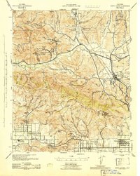 1943 Santa Susana1943 Print · USGSSouthern California ranching and oil industries intersect in the early 1940s along the Santa Susana Mountains. Trace historic boundaries and sites like Tapo Ranch, the Newhall-Potrero Oil Field, and the Southern Pacific rail line.
 - 1943 Map of Triunfo Pass
 1943 Triunfo Pass1943 Print · USGSThe Conejo Valley and Santa Monica Mountains are shown here during the early war years, when ranching and small coastal outposts defined the region. Local researchers can locate family landholdings like Fillmore Ranch or trace the early development of the Thousand Oaks Community and Newbury Park.
 - 1944 Map of Calabasas
 1944 Calabasas1944 Print · USGSMid-century Los Angeles County unfolds here, showing the grid of the San Fernando Valley meeting the Santa Monica Mountains. Trace old ranch boundaries at Platt Ranch or locate early landmarks like the Will Rogers Memorial and Topanga Lookout.
 - 1949 Map of Los Angeles
 1949 Los Angeles1949 Print · USGSSouthern California and the South Coast appear at the onset of the post-war boom, from the Channel Islands to the Mojave Desert. Trace early aviation sites like Lockheed Air Terminal and mining history at the Redrock Quicksilver Mine and Redrover Mine.2 unique versions available
End of results
Showing maps 1-8 of 8
Top cities near Simi Valley
- Los Angeles historical maps
- Santa Clarita historical maps
- Thousand Oaks historical maps
- Santa Monica historical maps
- Moorpark historical maps
- Calabasas historical maps
See more
Top neighborhoods of Simi Valley
- Highlands at Big Sky historical maps
- The Bluffs historical maps
- Jasmine Glen Estates historical maps
- Windstone at Big Sky historical maps
- Alamo Villas historical maps
- Tradewinds Club historical maps
See more
Frequently asked questions
- What are the different types of historical maps available for Simi Valley?
- What is the oldest map of Simi Valley?
- Where can I purchase historical maps of Simi Valley for my home or office?
- Where can I download high-res historical maps of Simi Valley?
- Are there historical topographic maps available for Simi Valley?
- Is there historical aerial imagery available for Simi Valley?
- Where are historical maps of Simi Valley sourced from?