1950s Maps of Simi Valley, California
Explore 7 historic maps of Simi Valley from the 1950s. These maps offer a rare glimpse into what life looked like during the 1950s — showing old roads, neighborhoods, homes, and landmarks that have changed or disappeared over time.
Whether you're researching your family's past, planning a metal detecting trip, or studying how Simi Valley's landscape evolved across the 1950s, these high-resolution maps are a powerful tool for exploring the history of this region.
- Focus on a specific era: All maps on this page are from the 1950s, giving you a focused view of this time period.
- See what’s changed: Compare century-old streets, trails, and buildings to today's modern landscape using overlays and satellite layers.
- Research with precision: Use these maps for genealogy, historical research, land use analysis, or educational projects.
- View, download, or print: Maps are fully viewable online in high resolution, and can be downloaded or printed for your own records.
Start exploring Simi Valley's history through authentic maps from the 1950s. This is your window into the past.
Simi Valley, CA maps
(7)- 1950 Map of Thousand Oaks, 1955 Print
 1950 Thousand Oaks1955 Print · USGSThousand Oaks and the surrounding ranch lands are shown here in the early fifties, just as the regional highway network began to modernize. Researchers can locate early community hubs like Triunfo Corner, Greenwich Village, and the Conejo Sch.5 unique versions available
 - 1951 Map of Simi, 1952 Print
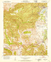
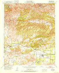 1951 Simi1952 Print · USGSSimi Valley and Moorpark are captured in the early fifties during an era of agricultural prosperity and early suburban planning. Genealogists and local historians can locate the Virginia Colony settlement, the Simi Sta railroad stop, and the Cem south of the tracks.6 unique versions available
 - 1951 Map of Santa Susana, 1952 Print
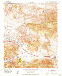
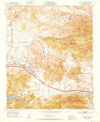
 1951 Santa Susana1952 Print · USGSSimi Valley and the surrounding mountains are captured here in the early fifties, showing the region before modern suburban expansion. Researchers can trace ranching history at Tapo Ranch, locate the Santa Susana Airport, or follow the Southern Pacific line through the Santa Susana Tunnel.6 unique versions available
 - 1952 Map of Thousand Oaks
 1952 Thousand Oaks1952 Print · USGSThousand Oaks and the Conejo Valley are captured in the early fifties, just as this ranching region began to modernize. Researchers can locate the original Conejo School, the Conejo Valley Airport, and old landmarks like Triunfo Corner and the Olson Cemetery.
 - 1952 Map of Calabasas, 1953 Print
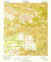
 1952 Calabasas1953 Print · USGSThe western San Fernando Valley meets the Simi Hills in the early fifties, showing a landscape of foothill ranching and early canyon communities. Genealogists can locate family landmarks like Chatsworth Lake Manor, the L A Pet Cemetery, and Las Virgenes School.9 unique versions available
 - 1955 Map of Los Angeles
 1955 Los Angeles1955 Print · USGSThe mid-century transformation of Southern California comes into focus as the urban sprawl of Los Angeles meets the wilderness of the Santa Monica Mountains. Researchers can trace the development of post-war suburbs alongside historic landmarks like the Santa Barbara Lighthouse and early industrial sites such as the Good Luck Mine.
 - 1959 Map of Los Angeles
 1959 Los Angeles1959 Print · USGSCoastal California and the high desert met in a period of booming growth after the war. Researchers can trace early aviation and military history at the Point Mugu Air Missile Test Ctr or locate desert mining sites like the Double Eagle Mine.3 unique versions available
End of results
Showing maps 1-7 of 7
Top cities near Simi Valley
- Los Angeles historical maps
- Santa Clarita historical maps
- Thousand Oaks historical maps
- Santa Monica historical maps
- Moorpark historical maps
- Calabasas historical maps
See more
Top neighborhoods of Simi Valley
- Highlands at Big Sky historical maps
- The Bluffs historical maps
- Jasmine Glen Estates historical maps
- Windstone at Big Sky historical maps
- Alamo Villas historical maps
- Tradewinds Club historical maps
See more
Frequently asked questions
- What are the different types of historical maps available for Simi Valley?
- What is the oldest map of Simi Valley?
- Where can I purchase historical maps of Simi Valley for my home or office?
- Where can I download high-res historical maps of Simi Valley?
- Are there historical topographic maps available for Simi Valley?
- Is there historical aerial imagery available for Simi Valley?
- Where are historical maps of Simi Valley sourced from?