1970s Maps of Davis, California
Explore 2 historic maps of Davis from the 1970s. These maps offer a rare glimpse into what life looked like during the 1970s — showing old roads, neighborhoods, homes, and landmarks that have changed or disappeared over time.
Whether you're researching your family's past, planning a metal detecting trip, or studying how Davis's landscape evolved across the 1970s, these high-resolution maps are a powerful tool for exploring the history of this region.
- Focus on a specific era: All maps on this page are from the 1970s, giving you a focused view of this time period.
- See what’s changed: Compare century-old streets, trails, and buildings to today's modern landscape using overlays and satellite layers.
- Research with precision: Use these maps for genealogy, historical research, land use analysis, or educational projects.
- View, download, or print: Maps are fully viewable online in high resolution, and can be downloaded or printed for your own records.
Start exploring Davis's history through authentic maps from the 1970s. This is your window into the past.
Davis, CA maps
(2)- 1970 Map of Davis
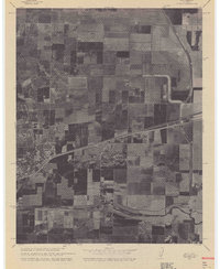 1970 Davis1970 Print · USGSCovers Davis, including El Macero, Swingle, and other nearby areas
 - 1975 Map of Davis, 1977 Print
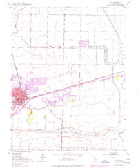 1975 Davis1977 Print · USGSThe university town of Davis expands into the Yolo County agricultural landscape during the mid-seventies. Trace local history through the Univ Of Calif campus, the Davis Cem, and early suburbs like El Macero or the Swingle siding.
End of results
Showing maps 1-2 of 2
Top cities near Davis
- Sacramento historical maps
- Vacaville historical maps
- Woodland historical maps
- West Sacramento historical maps
- Dixon historical maps
- Winters historical maps
See more
Top neighborhoods of Davis
- Central Davis historical maps
- South Davis historical maps
- West Davis historical maps
- East Davis historical maps
Frequently asked questions
- What are the different types of historical maps available for Davis?
- What is the oldest map of Davis?
- Where can I purchase historical maps of Davis for my home or office?
- Where can I download high-res historical maps of Davis?
- Are there historical topographic maps available for Davis?
- Is there historical aerial imagery available for Davis?
- Where are historical maps of Davis sourced from?