1990s Maps of Davis, California
Explore 3 historic maps of Davis from the 1990s. These maps offer a rare glimpse into what life looked like during the 1990s — showing old roads, neighborhoods, homes, and landmarks that have changed or disappeared over time.
Whether you're researching your family's past, planning a metal detecting trip, or studying how Davis's landscape evolved across the 1990s, these high-resolution maps are a powerful tool for exploring the history of this region.
- Focus on a specific era: All maps on this page are from the 1990s, giving you a focused view of this time period.
- See what’s changed: Compare century-old streets, trails, and buildings to today's modern landscape using overlays and satellite layers.
- Research with precision: Use these maps for genealogy, historical research, land use analysis, or educational projects.
- View, download, or print: Maps are fully viewable online in high resolution, and can be downloaded or printed for your own records.
Start exploring Davis's history through authentic maps from the 1990s. This is your window into the past.
Davis, CA maps
(3)- 1992 Map of Merritt, 1997 Print
 1992 Merritt1997 Print · USGSYolo County is captured here in the early nineties as the university town and its agricultural surroundings expand. Researchers can trace the development of Plainfield, the irrigation routes of Willow Slough, and the boundaries of the University of California.
 - 1992 Map of Davis, 1997 Print
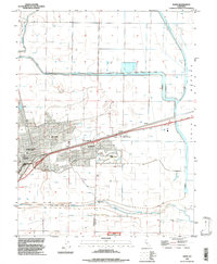 1992 Davis1997 Print · USGSDavis and its university campus are captured in the early 1990s as the town expanded into the surrounding Sacramento Valley farmlands. Researchers can trace local landmarks like Davis Cemetery or old railroad stops at Swingle and Webster.
 - 1994 Map of Sacramento
 1994 Sacramento1994 Print · USGSThe Sacramento valley was a landscape of massive flood control and military aviation during the mid-nineties. Researchers can trace the complex network of the Yolo Bypass and the Sacramento River alongside McClellan Air Force Base and Zamora.2 unique versions available
End of results
Showing maps 1-3 of 3
Top cities near Davis
- Sacramento historical maps
- Vacaville historical maps
- Woodland historical maps
- West Sacramento historical maps
- Dixon historical maps
- Winters historical maps
See more
Top neighborhoods of Davis
- Central Davis historical maps
- South Davis historical maps
- West Davis historical maps
- East Davis historical maps
Frequently asked questions
- What are the different types of historical maps available for Davis?
- What is the oldest map of Davis?
- Where can I purchase historical maps of Davis for my home or office?
- Where can I download high-res historical maps of Davis?
- Are there historical topographic maps available for Davis?
- Is there historical aerial imagery available for Davis?
- Where are historical maps of Davis sourced from?