Old Maps of Saxon, California for Genealogy
Trace your family roots with 13 historic maps of Saxon. These high-res maps reveal old neighborhoods, homesites, landmarks, and streets — helping you uncover where your ancestors lived and how the area evolved over time.
- Explore historic neighborhoods: Identify where your relatives may have lived in the 1800s or 1900s.
- Compare maps over time: Trace the changes in streets, buildings, and landmarks for multi-generational research.
- Perfect for genealogy & ancestry research: Used by family historians and researchers to map out lineage and migration.
These maps are an incredible resource for exploring your personal connection to Saxon's past.
Saxon, CA maps
(13)- 1908 Map of Courtland
 1908 Courtland1908 Print · USGSThe Sacramento Delta at the dawn of the twentieth century was a landscape of fertile river islands and vital waterborne transit. Genealogists and historians can trace the early footprints of Courtland, Clarksburg, and Freeport, or locate landmarks like the Free County Ferry and Indian Mound.3 unique versions available
 - 1916 Map of Saxon
 1916 Saxon1916 Print · USGSAgricultural lands in Solano and Yolo counties are captured here in the early twentieth century, split by a prominent railroad. Trace the path of the Oakland Antioch and Eastern through the valley and locate the small stops at Saxon and Millar.
 - 1947 Map of Sacramento, 1948 Print
 1947 Sacramento1948 Print · USGSThe Sacramento Valley meets the high Sierra during a period of post-war expansion. Trace the historic river delta islands like Grand Island or locate early airfield footprints at McClellan Air Force Base and Mather Air Force Base.2 unique versions available
 - 1948 Map of Sacramento, 1951 Print
 1948 Sacramento1951 Print · USGSPost-war Northern California comes alive in this regional survey, capturing the era of expansion between the Central Valley and the High Sierra. Researchers can trace the rail networks of the Central California Traction and Sacramento Northern RR or locate landmarks like the State Capitol and University of California Davis.
 - 1952 Map of Saxon, 1953 Print
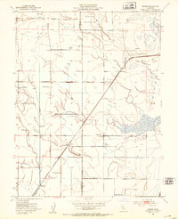 1952 Saxon1953 Print · USGSSolano and Yolo counties are captured here in the early fifties, showing a landscape of established ranching and strategic water management. Genealogists and local historians can trace family-named lands like Bulkley Ranch and find the historic Tremont Cem near the Sacramento Northern line.5 unique versions available
 - 1952 Map of Courtland, 1959 Print
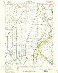 1952 Courtland1959 Print · USGSThe Sacramento Delta comes alive in the early fifties, showing a landscape defined by river commerce and sprawling ranch holdings. Family researchers can locate Tremont Cem, Liberty Sch, and long-established properties like Glide Ranch and Maxwell Ranch.3 unique versions available
 - 1956 Map of Sacramento
 1956 Sacramento1956 Print · USGSMid-century California unfolds from the delta to the high Sierra, capturing a landscape of growing valley cities and burgeoning military airbases. Genealogists and historians can trace the rail lines and river towns from Woodland to Lodi, or explore the foothill settlements of Placerville and Jackson.2 unique versions available
 - 1957 Map of Sacramento, 1966 Print
 1957 Sacramento1966 Print · USGSIn the mid-twentieth century, the California heartland was a hub of river transport, rail lines, and military airbases. Genealogists and historians can trace the development of Gold Country towns like Angels Camp and Sonora or follow the path of the Southern Pacific RR through the growing suburbs of Sacramento.4 unique versions available
 - 1993 Map of Lodi, 1994 Print
 1993 Lodi1994 Print · USGSNorthern California's delta country and the growing Central Valley corridors are captured here in the early nineties. Genealogists and historians can trace the intricate island tracts, old railroad lines like the Sacramento Northern RR, and established local landmarks including the Lodi Memorial Cemetery and University of the Pacific.2 unique versions available
 - 2012 Map of Saxon, 2012 Print
 2012 Saxon2012 Print · USGSCovers Saxon, including Yolano, Solano County, and other nearby areas
 - 2015 Map of Saxon, 2015 Print
 2015 Saxon2015 Print · USGSCovers Saxon, including Yolano, Solano County, and other nearby areas
 - 2018 Map of Saxon, 2018 Print
 2018 Saxon2018 Print · USGSCovers Saxon, including Yolano, Solano County, and other nearby areas
 - 2022 Map of Saxon, 2022 Print
 2022 Saxon2022 Print · USGSThe Central Sacramento Valley at the start of the 2020s is a landscape of high-stakes hydrology and deep-rooted agriculture. Genealogists and researchers can trace the vicinity of Saxon and Yolano, or locate the Tremont Cem north of the Toe Drain.
End of results
Showing maps 1-13 of 13
Top cities near Saxon
- Sacramento historical maps
- Davis historical maps
- Woodland historical maps
- West Sacramento historical maps
- Dixon historical maps
- El Macero historical maps
Frequently asked questions
- What are the different types of historical maps available for Saxon?
- What is the oldest map of Saxon?
- Where can I purchase historical maps of Saxon for my home or office?
- Where can I download high-res historical maps of Saxon?
- Are there historical topographic maps available for Saxon?
- Is there historical aerial imagery available for Saxon?
- Where are historical maps of Saxon sourced from?