1950s Maps of Winters, California
Explore 7 historic maps of Winters from the 1950s. These maps offer a rare glimpse into what life looked like during the 1950s — showing old roads, neighborhoods, homes, and landmarks that have changed or disappeared over time.
Whether you're researching your family's past, planning a metal detecting trip, or studying how Winters's landscape evolved across the 1950s, these high-resolution maps are a powerful tool for exploring the history of this region.
- Focus on a specific era: All maps on this page are from the 1950s, giving you a focused view of this time period.
- See what’s changed: Compare century-old streets, trails, and buildings to today's modern landscape using overlays and satellite layers.
- Research with precision: Use these maps for genealogy, historical research, land use analysis, or educational projects.
- View, download, or print: Maps are fully viewable online in high resolution, and can be downloaded or printed for your own records.
Start exploring Winters's history through authentic maps from the 1950s. This is your window into the past.
Winters, CA maps
(7)- 1953 Map of Winters, 1954 Print
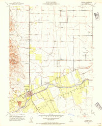 1953 Winters1954 Print · USGSThe Yolo-Solano border comes alive in this mid-century survey of the agricultural valley floor and rising foothills. Local historians can trace the Southern Pacific rail line through Arroz or locate rural landmarks like Buckeye School and Putah Creek.6 unique versions available
 - 1953 Map of Woodland, 1959 Print
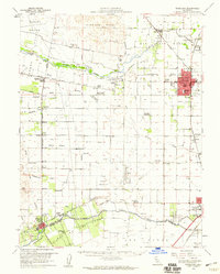 1953 Woodland1959 Print · USGSWoodland and the Central Valley are captured here in the early fifties as the region's agricultural and rail infrastructure matured. Genealogists can locate family landmarks like the Cottonwood Cemetery and numerous rural schools including Fairfield Sch and Wolfskill Sch.2 unique versions available
 - 1956 Map of Sacramento
 1956 Sacramento1956 Print · USGSMid-century California unfolds from the delta to the high Sierra, capturing a landscape of growing valley cities and burgeoning military airbases. Genealogists and historians can trace the rail lines and river towns from Woodland to Lodi, or explore the foothill settlements of Placerville and Jackson.2 unique versions available
 - 1957 Map of Sacramento, 1966 Print
 1957 Sacramento1966 Print · USGSIn the mid-twentieth century, the California heartland was a hub of river transport, rail lines, and military airbases. Genealogists and historians can trace the development of Gold Country towns like Angels Camp and Sonora or follow the path of the Southern Pacific RR through the growing suburbs of Sacramento.4 unique versions available
 - 1958 Map of Santa Rosa, 1968 Print
 1958 Santa Rosa1968 Print · USGSThe North Bay and Wine Country are captured in the mid-twentieth century as the region balanced its agricultural roots with a growing military and recreational footprint. Researchers can trace the Northwestern Pacific RR through the Russian River valley or locate landmarks like the Petaluma Adobe Historical Monument and The Geysers Resort.3 unique versions available
 - 1959 Map of Lake Berryessa, 1961 Print
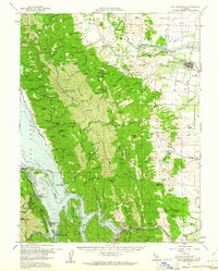 1959 Lake Berryessa1961 Print · USGSThe Yolo and Napa County borderlands are seen here just after the completion of the Monticello Dam. Researchers can trace early recreational sites like Spanish Flat Resort and the Southern Pacific rail line through Esparto.2 unique versions available
 - 1959 Map of Monticello Dam, 1961 Print
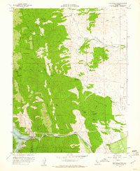 1959 Monticello Dam1961 Print · USGSThe foothills of the Vaca Mountains meet the Sacramento Valley in the late fifties as Lake Berryessa forms behind the new Monticello Dam. Local researchers can trace family lands like Cowell Ranch and investigate early energy sites like the Gas Well clusters on the eastern plains.4 unique versions available
End of results
Showing maps 1-7 of 7
Top cities near Winters
- Fairfield historical maps
- Vacaville historical maps
- Davis historical maps
- Woodland historical maps
- Dixon historical maps
- Esparto historical maps
Frequently asked questions
- What are the different types of historical maps available for Winters?
- What is the oldest map of Winters?
- Where can I purchase historical maps of Winters for my home or office?
- Where can I download high-res historical maps of Winters?
- Are there historical topographic maps available for Winters?
- Is there historical aerial imagery available for Winters?
- Where are historical maps of Winters sourced from?