1910s Maps of Woodland, California
Explore 2 historic maps of Woodland from the 1910s. These maps offer a rare glimpse into what life looked like during the 1910s — showing old roads, neighborhoods, homes, and landmarks that have changed or disappeared over time.
Whether you're researching your family's past, planning a metal detecting trip, or studying how Woodland's landscape evolved across the 1910s, these high-resolution maps are a powerful tool for exploring the history of this region.
- Focus on a specific era: All maps on this page are from the 1910s, giving you a focused view of this time period.
- See what’s changed: Compare century-old streets, trails, and buildings to today's modern landscape using overlays and satellite layers.
- Research with precision: Use these maps for genealogy, historical research, land use analysis, or educational projects.
- View, download, or print: Maps are fully viewable online in high resolution, and can be downloaded or printed for your own records.
Start exploring Woodland's history through authentic maps from the 1910s. This is your window into the past.
Woodland, CA maps
(2)- 1915 Map of Yolo
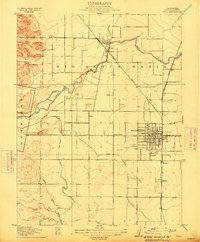 1915 Yolo1915 Print · USGSThe Yolo County plains are shown here at a time of rapid agricultural growth, as rail lines and irrigation canals reshaped the valley. Trace the early layout of Woodland and the vanished rail sidings at Mill Spur and Elvaton.
 - 1916 Map of Grays Bend
 1916 Grays Bend1916 Print · USGSYolo County at the start of the twentieth century shows a landscape transitioning through large-scale drainage and rail expansion. Genealogists can trace family-named sites like Langenour and Curtis along the Sacramento and Woodland rail line.
End of results
Showing maps 1-2 of 2
Top cities near Woodland
- Sacramento historical maps
- Davis historical maps
- West Sacramento historical maps
- Dixon historical maps
- Winters historical maps
- El Macero historical maps
Frequently asked questions
- What are the different types of historical maps available for Woodland?
- What is the oldest map of Woodland?
- Where can I purchase historical maps of Woodland for my home or office?
- Where can I download high-res historical maps of Woodland?
- Are there historical topographic maps available for Woodland?
- Is there historical aerial imagery available for Woodland?
- Where are historical maps of Woodland sourced from?