1940s Maps of Commerce City, Colorado
Explore 10 historic maps of Commerce City from the 1940s. These maps offer a rare glimpse into what life looked like during the 1940s — showing old roads, neighborhoods, homes, and landmarks that have changed or disappeared over time.
Whether you're researching your family's past, planning a metal detecting trip, or studying how Commerce City's landscape evolved across the 1940s, these high-resolution maps are a powerful tool for exploring the history of this region.
- Focus on a specific era: All maps on this page are from the 1940s, giving you a focused view of this time period.
- See what’s changed: Compare century-old streets, trails, and buildings to today's modern landscape using overlays and satellite layers.
- Research with precision: Use these maps for genealogy, historical research, land use analysis, or educational projects.
- View, download, or print: Maps are fully viewable online in high resolution, and can be downloaded or printed for your own records.
Start exploring Commerce City's history through authentic maps from the 1940s. This is your window into the past.
Commerce City, CO maps
(10)- 1940 Map of Brighton
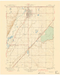 1940 Brighton1940 Print · USGSThe irrigated farmlands of Adams County come to life in this pre-war survey of the South Platte Valley. Genealogists and local historians can trace the footprint of the Denver Poor Farm and old rural schools like Pleasant Plains Sch or Cactus Ridge School.
 - 1940 Map of Eastlake
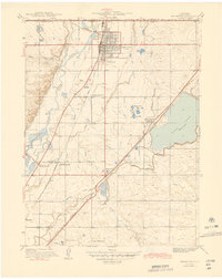
 1940 Eastlake1940 Print · USGSAdams County at the end of the 1930s shows a landscape of rail-side settlements and intensive irrigation. Genealogists can locate family landmarks like Wesley Chapel, rural school sites such as Moreland Sch, and the water networks of the Brantner Ditch.
 - 1940 Map of Derby
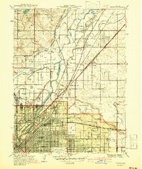 1940 Derby1940 Print · USGSAdams County and north Denver appear here on the eve of World War II, showing a landscape of irrigation ditches, heavy rail, and early aviation. Researchers can trace the legacy of the Stockyards, the sprawling Denver City and Co Airport, and vanished local schools like Mapleton Sch.2 unique versions available
 - 1941 Map of Long Branch
 1941 Long Branch1941 Print · USGSThe high plains of Adams County were undergoing a period of vital irrigation and military growth just before the mid-century. Researchers can trace the early layout of Aurora, the massive Fitzsimons General Hospital campus, and the rural rail stops at Sable and Irondale.
 - 1942 Map of Mile High Lakes
 1942 Mile High Lakes1942 Print · USGSAdams County ranching and water engineering are on full display in the early 1940s, as a network of canals transformed the High Plains. Genealogists and local historians can trace legacy holdings like Patton Ranch and Miliken Ranch or locate the vital Klink Siding along the railroad.
 - 1942 Map of Box Elder School
 1942 Box Elder School1942 Print · USGSAdams County ranching and irrigation systems are in full view just before the mid-century, as the city of Denver begins to expand eastward. Trace the early rural school districts at Box Elder Sch and First Creek Sch or follow the path of the Highline Canal.
 - 1944 Map of Brighton
 1944 Brighton1944 Print · USGSThe agricultural heart of the South Platte Valley is captured here during the mid-forties as irrigation and railroads transformed the plains. Genealogists and local historians can trace the foundations of Brighton and find vanished sites like the Denver Poor Farm or Pleasant Plains Sch.
 - 1944 Map of Eastlake
 1944 Eastlake1944 Print · USGSThe South Platte River valley and the agricultural plains of Adams County appear here in the years before the Denver suburbs arrived. Genealogists and historians can trace rural family life through locations like Wesley Chapel, the local Cemetery, and early school sites like Brantner Sch.
 - 1947 Map of Derby
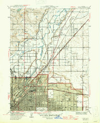 1947 Derby1947 Print · USGSDenver's northern periphery at the end of the 1930s reveals a landscape defined by industry and irrigation. Trace family roots at Riverside Cemetery or locate early landmarks like the Stockyards, Argo, and the Fish Hatchery.2 unique versions available
 - 1948 Map of Long Branch
 1948 Long Branch1948 Print · USGSEast of Denver in the late 1940s, this area shows a landscape of military hospitals and emerging settlements tied to the rail lines. Trace the grounds of Fitzsimons General Hospital or follow the Highline Canal past Irondale and Sable.
End of results
Showing maps 1-10 of 10
Top cities near Commerce City
- Denver historical maps
- Aurora historical maps
- Thornton historical maps
- Westminster historical maps
- Centennial historical maps
- Northglenn historical maps
See more
Top neighborhoods of Commerce City
- Irondale historical maps
- Rolla historical maps
- Hazeltine Heights historical maps
- Eno historical maps
- Adams City historical maps
Frequently asked questions
- What are the different types of historical maps available for Commerce City?
- What is the oldest map of Commerce City?
- Where can I purchase historical maps of Commerce City for my home or office?
- Where can I download high-res historical maps of Commerce City?
- Are there historical topographic maps available for Commerce City?
- Is there historical aerial imagery available for Commerce City?
- Where are historical maps of Commerce City sourced from?