1980s Maps of Pagosa Springs, Colorado
Explore 4 historic maps of Pagosa Springs from the 1980s. These maps offer a rare glimpse into what life looked like during the 1980s — showing old roads, neighborhoods, homes, and landmarks that have changed or disappeared over time.
Whether you're researching your family's past, planning a metal detecting trip, or studying how Pagosa Springs's landscape evolved across the 1980s, these high-resolution maps are a powerful tool for exploring the history of this region.
- Focus on a specific era: All maps on this page are from the 1980s, giving you a focused view of this time period.
- See what’s changed: Compare century-old streets, trails, and buildings to today's modern landscape using overlays and satellite layers.
- Research with precision: Use these maps for genealogy, historical research, land use analysis, or educational projects.
- View, download, or print: Maps are fully viewable online in high resolution, and can be downloaded or printed for your own records.
Start exploring Pagosa Springs's history through authentic maps from the 1980s. This is your window into the past.
Pagosa Springs, CO maps
(4)- 1983 Map of Durango
 1983 Durango1983 Print · USGSSouthwestern Colorado at the start of the 1980s shows a landscape where high-mountain wilderness meets the agricultural plateaus of the Southern Ute. Genealogists and historians can trace the Durango & Silverton Narrow Gauge Railroad or locate sites like Southern Ute Agency and Pagosa Junction.
 - 1984 Map of Oak Brush Hill
 1984 Oak Brush Hill1984 Print · USGSThe Southern Ute Reservation and San Juan National Forest meet in this 1980s study of the high mesas and river canyons. Researchers can trace the Old Indian Treaty Boundary and locate landmarks like Echo Canyon Reservoir and Oak Brush Hill.
 - 1984 Map of Jackson Mountain
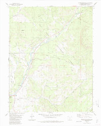 1984 Jackson Mountain1984 Print · USGSThe mountain landscape surrounding Pagosa Springs comes into focus during the mid-eighties as a hub of forest management and river valley life. Genealogists and historians can trace local landmarks like the Rodeo Ground, the Guard Sta, and family-named features such as Jackson Mountain.4 unique versions available
 - 1985 Map of Antonito
 1985 Antonito1985 Print · USGSThe Colorado and New Mexico borderlands come into focus during the mid-eighties as the high peaks of the San Juans meet the San Luis Valley. Trace the winding Cumbres and Toltec Scenic Railroad or locate historical mining sites like the Black Diamond Mine and Summitville.2 unique versions available
End of results
Showing maps 1-4 of 4
Frequently asked questions
- What are the different types of historical maps available for Pagosa Springs?
- What is the oldest map of Pagosa Springs?
- Where can I purchase historical maps of Pagosa Springs for my home or office?
- Where can I download high-res historical maps of Pagosa Springs?
- Are there historical topographic maps available for Pagosa Springs?
- Is there historical aerial imagery available for Pagosa Springs?
- Where are historical maps of Pagosa Springs sourced from?