2000-2009 Maps of Conejos County, Colorado
Explore 14 historic maps of Conejos County from 2000-2009. These maps offer a rare glimpse into what life looked like during the 2000s — showing old roads, neighborhoods, homes, and landmarks that have changed or disappeared over time.
Whether you're researching your family's past, planning a metal detecting trip, or studying how Conejos County's landscape evolved across the 2000s, these high-resolution maps are a powerful tool for exploring the history of this region.
- Focus on a specific era: All maps on this page are from the 2000s, giving you a focused view of this time period.
- See what’s changed: Compare century-old streets, trails, and buildings to today's modern landscape using overlays and satellite layers.
- Research with precision: Use these maps for genealogy, historical research, land use analysis, or educational projects.
- View, download, or print: Maps are fully viewable online in high resolution, and can be downloaded or printed for your own records.
Start exploring Conejos County's history through authentic maps from the 2000s. This is your window into the past.
Conejos County, CO maps
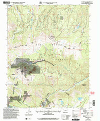
(14)- 2001 Map of Elwood Pass, 2005 Print
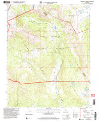
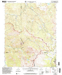 2001 Elwood Pass2005 Print · USGSHigh in the San Juan Mountains at the turn of the twenty-first century, this landscape preserves the rugged intersection of the Continental Divide. Researchers can trace historic alpine routes and prospecting sites like Elwood Pass, Black Diamond Mine, and McCormick Cabin.2 unique versions available
 - 2001 Map of Platoro, 2005 Print
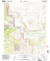
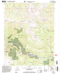
 2001 Platoro2005 Print · USGSThe high-country mining and ranching traditions of Conejos County are captured here at the turn of the twenty-first century. Genealogists and historians can trace the Stock Driveway, locate the Mammoth Revenue Mine, and explore the upper Conejos River near Platoro.
 - 2001 Map of Terrace Reservoir, 2005 Print
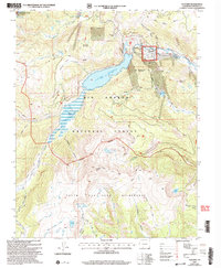
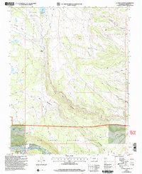
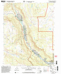
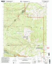
 2001 Terrace Reservoir2005 Print · USGSSouthern Colorado's high-country ranching and water management are captured here at the start of the millennium. Researchers can locate seasonal family outposts like Shawcroft Cow Camp and trace the shores of Terrace Reservoir and La Jara Reservoir.
 - 2001 Map of Red Mountain, 2005 Print
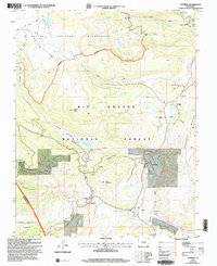
 2001 Red Mountain2005 Print · USGSThe high country of the southern San Juans comes alive in this millennial revision, showing the intricate seasonal grazing and water networks. Researchers can trace the legacy of ranching and land use through the Stock Driveway, Lake Fork Ranch, and the Jim Creek Cow Camp.
 - 2001 Map of Archuleta Creek, 2005 Print
 2001 Archuleta Creek2005 Print · USGSThe high country of Archuleta and Conejos counties is captured here at the turn of the millennium, defined by the Tierra Amarilla Grant. Researchers can trace old mountain routes like the West Fork Trail and locate the historic Archuleta Corral along the Rio Chama.
 - 2001 Map of Fox Creek, 2005 Print
 2001 Fox Creek2005 Print · USGSThe high desert valley of Conejos County is captured here at the dawn of the millennium, showing the vital irrigation network of the Conejos River. Genealogists can locate family sites at Fox Creek Cem and the church at Las Mesitas Ch.
 - 2001 Map of La Jara Canyon, 2005 Print
 2001 La Jara Canyon2005 Print · USGSThe Conejos County high country is shown here at the turn of the millennium, dominated by the drainage of La Jara Canyon. Researchers can trace old mountain routes to Braiden Cow Camp, Chicago Bogs, and the shores of La Grulla Lake.
 - 2001 Map of Cumbres, 2005 Print
 2001 Cumbres2005 Print · USGSHigh in the San Juan Mountains at the turn of the millennium, this area shows the isolated rail stations and summer settlements of the southern Colorado border. Trace the winding Cumbres and Toltec Scenic Railroad through Cumbres Pass past the Snow Shed and remote Osier.
 - 2001 Map of Summitville, 2005 Print
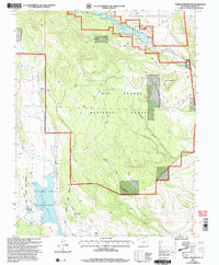
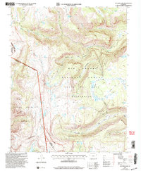
 2001 Summitville2005 Print · USGSThe high mountain mining district of Rio Grande County comes into focus at the start of the millennium. Local historians can trace the legacy of resource extraction through the Chandler Tunnel, the settlement at Summitville, and the Stunner Cabin.
 - 2001 Map of Summit Peak, 2005 Print
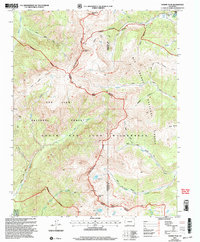 2001 Summit Peak2005 Print · USGSThe high alpine crest of the Colorado Rockies is documented here at the turn of the millennium. Hikers and historians can trace high-country routes like the Treasure Pass Trail and Stock Driveway past landmarks like Summit Peak and Lake Ann.
 - 2001 Map of Spectacle Lake, 2005 Print
 2001 Spectacle Lake2005 Print · USGSThe high San Juan Mountains are documented here at the start of the new millennium, showing the remote river valleys of the Rio Grande National Forest. Researchers can trace old mountain routes like the Notch Trail and locate historic backcountry sites such as Thomas Ranch and Bancos Cow Camp.
 - 2001 Map of Victoria Lake, 2005 Print
 2001 Victoria Lake2005 Print · USGSSouthern Colorado's high-altitude wilderness is captured here at the turn of the millennium, spanning the divide between national forests. Trace the historic Pierra Amarilla Grant and remote alpine waters like Victoria Lake and Chama Lake.2 unique versions available
 - 2001 Map of Jasper, 2005 Print
 2001 Jasper2005 Print · USGSHigh in the Rio Grande National Forest during the early 2000s, the terrain around the settlement of Jasper reveals a landscape of mining and forestry. Researchers can trace historical routes like the West Frisco Trail and locate family-named landmarks such as Bennett Peak and Cornwall Mountain.
 - 2001 Map of Greenie Mountain, 2005 Print
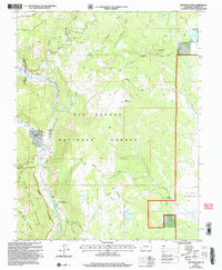
 2001 Greenie Mountain2005 Print · USGSThe Rio Grande high country is captured here at the start of the 2000s, showing a landscape defined by forest management and mountain recreation. Researchers can locate secluded sites like Lost Cabin Ranch, Camp Val Verde, and old mining works near Poison Gulch.
End of results
Showing maps 1-14 of 14
Top cities of Conejos County
- Manassa historical maps
- Sanford historical maps
- La Jara historical maps
- Antonito historical maps
- Romeo historical maps
Frequently asked questions
- What are the different types of historical maps available for Conejos County?
- What is the oldest map of Conejos County?
- Where can I purchase historical maps of Conejos County for my home or office?
- Where can I download high-res historical maps of Conejos County?
- Are there historical topographic maps available for Conejos County?
- Is there historical aerial imagery available for Conejos County?
- Where are historical maps of Conejos County sourced from?