1800s (19th Century) Maps of Crowley County, Colorado
Explore 8 historic maps of Crowley County from the 1800s (19th Century). These maps offer a rare glimpse into what life looked like during the 1800s — showing old roads, neighborhoods, homes, and landmarks that have changed or disappeared over time.
Whether you're researching your family's past, planning a metal detecting trip, or studying how Crowley County's landscape evolved across the 1800s, these high-resolution maps are a powerful tool for exploring the history of this region.
- Focus on a specific era: All maps on this page are from the 1800s, giving you a focused view of this time period.
- See what’s changed: Compare century-old streets, trails, and buildings to today's modern landscape using overlays and satellite layers.
- Research with precision: Use these maps for genealogy, historical research, land use analysis, or educational projects.
- View, download, or print: Maps are fully viewable online in high resolution, and can be downloaded or printed for your own records.
Start exploring Crowley County's history through authentic maps from the 1800s. This is your window into the past.
Crowley County, CO maps
(8)- 1889 Map of Sanborn, 1962 Print
 1889 Sanborn1962 Print · USGSEastern Colorado ranching country is captured here during the late 1880s as the open range gave way to established holdings. Researchers can locate early livestock operations like the Maryland Cattle Co. Ranch, Orcutt Ranch, and the Sanborn settlement.
 - 1891 Map of Sanborn
 1891 Sanborn1891 Print · USGSEastern Colorado ranching life at the end of the century centers on isolated outposts and seasonal watercourses. Genealogists can trace family holdings like the Fody Ranch and Orcutt Ranch or the small settlement at Sanborn.
 - 1891 Map of Catlin
 1891 Catlin1891 Print · USGSSoutheast Colorado's high plains were a landscape of competing rail lines and isolated ranching camps in the late nineteenth century. Genealogists and historians can trace the early development of Rocky Ford and Catlin along the Arkansas River or locate remote outposts like Lone Tree Ranch and Sheep Camp.
 - 1891 Map of Nepesta
 1891 Nepesta1891 Print · USGSSoutheast Colorado at the close of the 1880s reveals a landscape defined by the arrival of the rails along the Arkansas River. Researchers can trace early ranching sites like Skinner & Tabor Ranch and follow the competing paths of the Atchison Topeka and Santa Fe Railroad and the Missouri Pacific Railroad.
 - 1893 Map of Nepesta
 1893 Nepesta1893 Print · USGSSoutheast Colorado at the close of the nineteenth century is defined here by the arrival of the rails along the Arkansas River. Researchers can trace the early cattle and transit economy through the Skinner & Tabor Ranch, Chico Station, and the village of Nepesta.2 unique versions available
 - 1893 Map of Sanborn
 1893 Sanborn1893 Print · USGSEastern Colorado ranching country is documented here during the late frontier era, showing the early cattle operations and water rights of the high plains. Researchers can locate the Maryland Cattle Co. Ranch and trace the paths of Steel Fork and Horse Creek.4 unique versions available
 - 1893 Map of Big Springs
 1893 Big Springs1893 Print · USGSEastern Colorado ranching country is documented here in the late nineteenth century, showing the early homesteads and water sources of the high plains. Researchers can locate the early holdings of Galloway Ranch and Hancock Ranch or trace the drainage of Black Squirrel Creek.5 unique versions available
 - 1893 Map of Catlin
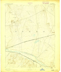 1893 Catlin1893 Print · USGSSoutheast Colorado at the close of the nineteenth century was a territory defined by the arrival of the rails and the flow of the Arkansas River. Genealogists and historians can trace early ranching and rail stops such as Rocky Ford, Lone Tree Ranch, and the isolated Double Dobe.5 unique versions available
End of results
Showing maps 1-8 of 8
Top cities of Crowley County
- Ordway historical maps
- Olney Springs historical maps
- Sugar City historical maps
- Crowley historical maps
Frequently asked questions
- What are the different types of historical maps available for Crowley County?
- What is the oldest map of Crowley County?
- Where can I purchase historical maps of Crowley County for my home or office?
- Where can I download high-res historical maps of Crowley County?
- Are there historical topographic maps available for Crowley County?
- Is there historical aerial imagery available for Crowley County?
- Where are historical maps of Crowley County sourced from?