1960s Maps of Crowley County, Colorado
Explore 4 historic maps of Crowley County from the 1960s. These maps offer a rare glimpse into what life looked like during the 1960s — showing old roads, neighborhoods, homes, and landmarks that have changed or disappeared over time.
Whether you're researching your family's past, planning a metal detecting trip, or studying how Crowley County's landscape evolved across the 1960s, these high-resolution maps are a powerful tool for exploring the history of this region.
- Focus on a specific era: All maps on this page are from the 1960s, giving you a focused view of this time period.
- See what’s changed: Compare century-old streets, trails, and buildings to today's modern landscape using overlays and satellite layers.
- Research with precision: Use these maps for genealogy, historical research, land use analysis, or educational projects.
- View, download, or print: Maps are fully viewable online in high resolution, and can be downloaded or printed for your own records.
Start exploring Crowley County's history through authentic maps from the 1960s. This is your window into the past.
Crowley County, CO maps
(4)- 1960 Map of Fowler, 1961 Print
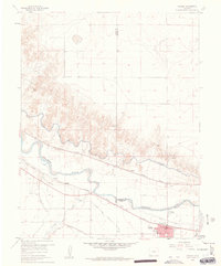 1960 Fowler1961 Print · USGSIn the Arkansas River valley during the early sixties, the local economy relied heavily on a sophisticated network of canals and competing rail lines. Researchers can trace the layout of Fowler and the settlement at Hamlet, or locate industrial sites like the Gravel Pits and the Rocky Ford Highline Canal.3 unique versions available
 - 1960 Map of Grandview School SE, 1962 Print
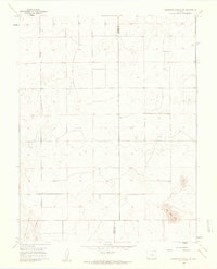 1960 Grandview School SE1962 Print · USGSThe Colorado high plains of the early sixties are defined by open range and the straight boundary line between Pueblo and Crowley counties. Researchers can trace the original section-line road network and locate distinctive natural features like Big Sand Hole.2 unique versions available
 - 1962 Map of Pueblo
 1962 Pueblo1962 Print · USGSThe Front Range and high plains meet in the early sixties as military installations and industrial mining shape the corridor from Colorado Springs to Pueblo. Genealogists can trace family names through rural landmarks like the Columbine School, Hanover Church, and Fairview Cem.
 - 1966 Map of Pueblo
 1966 Pueblo1966 Print · USGSThe Front Range and Arkansas River Valley are captured here in the mid-1960s, showing a landscape shaped by mining, military expansion, and rail. Researchers can locate numerous country schools and mines, such as the Lytle School, Pioneer Cem, and Empire Zinc Mine.
End of results
Showing maps 1-4 of 4
Top cities of Crowley County
- Ordway historical maps
- Olney Springs historical maps
- Sugar City historical maps
- Crowley historical maps
Frequently asked questions
- What are the different types of historical maps available for Crowley County?
- What is the oldest map of Crowley County?
- Where can I purchase historical maps of Crowley County for my home or office?
- Where can I download high-res historical maps of Crowley County?
- Are there historical topographic maps available for Crowley County?
- Is there historical aerial imagery available for Crowley County?
- Where are historical maps of Crowley County sourced from?