1950s Maps of Denver, Colorado
Explore 18 historic maps of Denver from the 1950s. These maps offer a rare glimpse into what life looked like during the 1950s — showing old roads, neighborhoods, homes, and landmarks that have changed or disappeared over time.
Whether you're researching your family's past, planning a metal detecting trip, or studying how Denver's landscape evolved across the 1950s, these high-resolution maps are a powerful tool for exploring the history of this region.
- Focus on a specific era: All maps on this page are from the 1950s, giving you a focused view of this time period.
- See what’s changed: Compare century-old streets, trails, and buildings to today's modern landscape using overlays and satellite layers.
- Research with precision: Use these maps for genealogy, historical research, land use analysis, or educational projects.
- View, download, or print: Maps are fully viewable online in high resolution, and can be downloaded or printed for your own records.
Start exploring Denver's history through authentic maps from the 1950s. This is your window into the past.
Denver, CO maps
(18)- 1950 Map of Derby
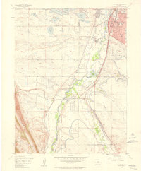
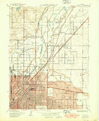 1950 Derby1950 Print · USGSThe northern reaches of Denver and Adams County are captured here at mid-century as industry and rail lines shaped the river valley. Researchers can trace the early footprints of Adams City, the Stockyards, and family history at Riverside Cemetery or Rose Hill Cem.
 - 1950 Map of Englewood
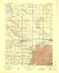
 1950 Englewood1950 Print · USGSDenver and Englewood are seen during a period of rapid post-war expansion, blending urban civic centers with emerging suburban country clubs. Researchers can trace historic burial sites at Fairmount Cemetery or locate the settlement of Sullivan near the Highline Canal.
 - 1950 Map of Arvada
 1950 Arvada1950 Print · USGSMid-century Jefferson County comes to life as Denver’s western edge begins its suburban transformation from a landscape of irrigation ditches and small farms. Researchers can trace the original footprints of Arvada, Wheatridge, and local landmarks like the Crown Hill Cemetery and Regis College.
 - 1951 Map of Manila, 1953 Print
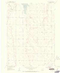
 1951 Manila1953 Print · USGSThe Colorado high plains of the early 1950s are captured here as a landscape of remote ranching and early aviation. Researchers can trace the path of the UNION PACIFIC through Manila or locate the site of the old CAA Beam Transmitter.2 unique versions available
 - 1952 Map of Horse Creek, 1953 Print
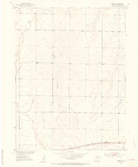
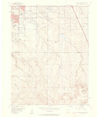
 1952 Horse Creek1953 Print · USGSAdams County ranching and water management define this mid-century prairie landscape just as the Missouri River Basin development was taking shape. Researchers can trace rural life through the locations of the Whittier School, Horse Creek Reservoir, and numerous Windmill sites.5 unique versions available
 - 1953 Map of Denver, 1964 Print
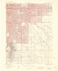
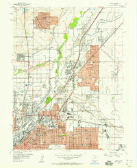
 1953 Denver1964 Print · USGSDenver and the Colorado Front Range are captured here during a decade of post-war growth and military expansion. Researchers can trace the sprawling rail lines of the Union Pacific, locate the State Capitol, and explore historic mountain mining hubs like Central City.6 unique versions available
 - 1957 Map of Denver
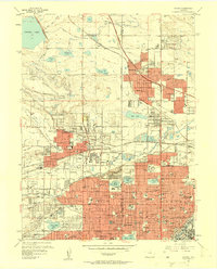
 1957 Denver1957 Print · USGSDenver and the Colorado Front Range are seen here during a mid-century period of intense military and urban expansion. Trace the footprints of the Rocky Mountain Arsenal, the early United States Air Force Academy, and the Lowry AF Base.
 - 1957 Map of Fort Logan, 1958 Print
 1957 Fort Logan1958 Print · USGSDenver's southwestern suburbs were in a period of significant postwar growth during the late fifties, blending military grounds with new residential tracts. Local historians can trace the footprints of the Fort Logan Military Reservation, the campus of Loretto Heights College, and the sprawling Federal Center.
 - 1957 Map of Sable, 1958 Print
 1957 Sable1958 Print · USGSThe outskirts of Denver and Aurora are captured in the late 1950s during a period of significant military and aviation growth. Researchers can trace the massive Rocky Mountain Arsenal, the sprawl of Fitzsimons Army Hospital, and the early layout of Stapleton Municipal Airport.2 unique versions available
 - 1957 Map of Highlands Ranch, 1958 Print
 1957 Highlands Ranch1958 Print · USGSDouglas and Arapahoe counties are shown here in the late fifties as the area south of Denver began its suburban transition. Genealogists and local historians can trace the foundations of Greenwood Village, the footprint of Cheese Ranch, and the early site of Bar None Airport.2 unique versions available
 - 1957 Map of Derby, 1958 Print
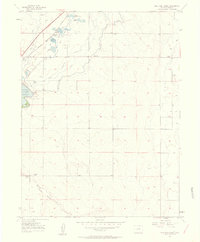
 1957 Derby1958 Print · USGSNortheast of Denver during the late fifties, this area was a bustling hub of rail transport, aviation, and emerging suburbs. Genealogists and historians can trace the foundations of Thornton or locate family plots in Riverside Cemetery and Rose Hill Cem.3 unique versions available
 - 1957 Map of Fitzsimons, 1958 Print
 1957 Fitzsimons1958 Print · USGSAurora and eastern Arapahoe County are captured here during a mid-century era of rapid growth and military activity. Researchers can find specific local landmarks like Mount Nebo Cem, Fitzsimons Army Hospital, and the Drive-in Theater.2 unique versions available
 - 1957 Map of Littleton, 1958 Print
 1957 Littleton1958 Print · USGSLittleton and the South Platte River valley are shown in the late fifties as suburban growth begins to overtake older ranch lands. Genealogists and local historians can trace the foundations of Littleton, find the Centennial Racetrack, and locate rural settlements like Acequia and Riverside.2 unique versions available
 - 1957 Map of Mile High Lakes, 1958 Print
 1957 Mile High Lakes1958 Print · USGSAdams County ranching and irrigation systems are frozen in time during the late fifties. You can trace the railroad corridor through Klink, locate the Green Valley Grange Hall, and explore the networks around Barr Lake and Patton Ranch.2 unique versions available
 - 1957 Map of Box Elder School, 1958 Print
 1957 Box Elder School1958 Print · USGSAdams County’s high plains are captured here in the late fifties, showing a rural landscape defined by ranching and early energy exploration. Researchers can find old schoolhouses like Box Elder Sch, the Sky Ranch Airport, and an Abandoned Canal crossing the prairie.4 unique versions available
 - 1957 Map of Englewood, 1958 Print
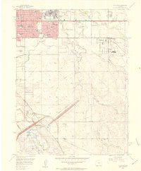
 1957 Englewood1958 Print · USGSDenver and Englewood are seen during a period of intense mid-century expansion, from the downtown state buildings to the nascent suburbs. Researchers can locate vanished institutions and early aviation sites like Lowry Air Force Base and Stapleton Field Municipal Airport.
 - 1957 Map of Arvada, 1958 Print
 1957 Arvada1958 Print · USGSThe northwest Denver suburbs are caught in a moment of post-war transformation, balancing old canal-fed agriculture with new residential growth. Local historians can trace established landmarks like Elitch Gardens, Regis College, and the sprawling Crown Hill Cemetery.3 unique versions available
 - 1958 Map of Denver
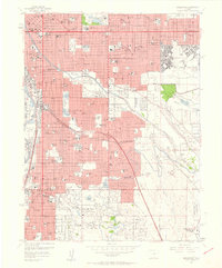
 1958 Denver1958 Print · USGSDenver and the Colorado Front Range are captured here during the mid-century suburban boom. Trace the footprints of military installations like Buckley Air Force Base alongside the established rail networks of the Colorado & Southern Ry.
End of results
Showing maps 1-18 of 18
Top cities of Denver
Frequently asked questions
- What are the different types of historical maps available for Denver?
- What is the oldest map of Denver?
- Where can I purchase historical maps of Denver for my home or office?
- Where can I download high-res historical maps of Denver?
- Are there historical topographic maps available for Denver?
- Is there historical aerial imagery available for Denver?
- Where are historical maps of Denver sourced from?