1960s Maps of Denver, Colorado
Explore 11 historic maps of Denver from the 1960s. These maps offer a rare glimpse into what life looked like during the 1960s — showing old roads, neighborhoods, homes, and landmarks that have changed or disappeared over time.
Whether you're researching your family's past, planning a metal detecting trip, or studying how Denver's landscape evolved across the 1960s, these high-resolution maps are a powerful tool for exploring the history of this region.
- Focus on a specific era: All maps on this page are from the 1960s, giving you a focused view of this time period.
- See what’s changed: Compare century-old streets, trails, and buildings to today's modern landscape using overlays and satellite layers.
- Research with precision: Use these maps for genealogy, historical research, land use analysis, or educational projects.
- View, download, or print: Maps are fully viewable online in high resolution, and can be downloaded or printed for your own records.
Start exploring Denver's history through authentic maps from the 1960s. This is your window into the past.
Denver, CO maps
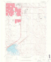
(11)- 1960 Map of Denver
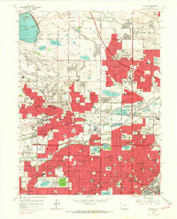
 1960 Denver1960 Print · USGSDenver and the Colorado Front Range are seen here at a pivotal moment of postwar expansion into the plains and foothills. Researchers can trace the mid-century rail network of the Denver & Rio Grande Western RR and locate historic institutional landmarks like Buckley Field and the Colorado School of Mines.
 - 1965 Map of Fitzsimons, 1966 Print
 1965 Fitzsimons1966 Print · USGSAurora and East Denver are captured during a period of intense mid-century growth, as military installations and suburban neighborhoods began to transform the plains. Genealogists and historians can locate dozens of local landmarks like Fitzsimons General Hospital, Highline Canal, and Meadow Hills Country Club.8 unique versions available
 - 1965 Map of Sable, 1966 Print
 1965 Sable1966 Print · USGSMid-century Adams County shows the rapid eastward growth of Denver and Aurora as suburban neighborhoods meet massive federal installations. Trace the boundaries of the Rocky Mountain Arsenal and locate vanished landmarks like Sable and the Sky Ranch Airport.7 unique versions available
 - 1965 Map of Englewood, 1967 Print
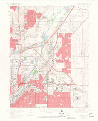
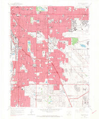 1965 Englewood1967 Print · USGSDenver and Englewood are shown during a period of rapid suburban maturation in the mid-sixties. Local researchers can trace the development of Lowry Air Force Base, the historic Fairmount Cemetery, and the urban sprawl surrounding the University of Denver.9 unique versions available
 - 1965 Map of Fort Logan, 1967 Print
 1965 Fort Logan1967 Print · USGSMid-century Denver and its southwestern suburbs are seen here during a period of rapid growth. Researchers can trace institutional footprints like Fort Logan and the Federal Correctional Institute alongside old rail lines and Marston Lake.5 unique versions available
 - 1965 Map of Arvada, 1967 Print
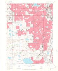
 1965 Arvada1967 Print · USGSThe northern Denver suburbs were undergoing a massive post-war expansion in the mid-sixties, filling the spaces between long-standing irrigation canals and rail lines. You can trace the development of local neighborhoods through landmarks like Regis College, Crown Hill Cemetery, and Belleview College.6 unique versions available
 - 1965 Map of Commerce City, 1967 Print
 1965 Commerce City1967 Print · USGSNorth Denver and its neighboring industrial suburbs come alive in the mid-1960s, showing a landscape defined by rail yards and aviation. Genealogists and historians can trace families near the Denver Union Stockyards, Riverside Cemetery, and schools like Clayton College for Boys.7 unique versions available
 - 1965 Map of Highlands Ranch, 1967 Print
 1965 Highlands Ranch1967 Print · USGSThe Highlands Ranch area is captured here during the mid-sixties as suburban neighborhoods began to push south from Denver. Researchers can trace the early footprint of Littleton and Greenwood Village alongside historic rural properties like McArthur Ranch and Cheesman Ranch.8 unique versions available
 - 1965 Map of Littleton, 1967 Print
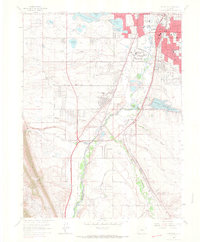 1965 Littleton1967 Print · USGSSouth of Denver in the mid-1960s, this area shows the early suburban transformation of the South Platte valley. Trace the dual rail lines serving Blakeland or locate landmarks like Centennial Racetrack and Columbine Airpark.5 unique versions available
 - 1966 Map of Mile High Lakes, 1967 Print
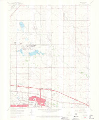
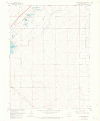 1966 Mile High Lakes1967 Print · USGSAdams County’s high plains irrigation network is fully established in this mid-sixties survey, showing the complex web of canals and reservoirs north of Denver. Researchers can trace historic water rights and rural landmarks like Barr Lake, Patton Ranch, and the Green Valley Grange Hall.5 unique versions available
 - 1966 Map of Box Elder School, 1967 Print
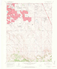
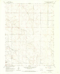 1966 Box Elder School1967 Print · USGSAdams County land was still defined by its creek beds and rural schoolhouses during the mid-sixties. Local researchers can trace family roots near Box Elder Sch or locate early landmarks like Sky Ranch Airport and the Union Pacific line.4 unique versions available
End of results
Showing maps 1-11 of 11
Top cities of Denver
Frequently asked questions
- What are the different types of historical maps available for Denver?
- What is the oldest map of Denver?
- Where can I purchase historical maps of Denver for my home or office?
- Where can I download high-res historical maps of Denver?
- Are there historical topographic maps available for Denver?
- Is there historical aerial imagery available for Denver?
- Where are historical maps of Denver sourced from?