1940s Maps of Happy Canyon Ranches, Colorado
Explore 2 historic maps of Happy Canyon Ranches from the 1940s. These maps offer a rare glimpse into what life looked like during the 1940s — showing old roads, neighborhoods, homes, and landmarks that have changed or disappeared over time.
Whether you're researching your family's past, planning a metal detecting trip, or studying how Happy Canyon Ranches's landscape evolved across the 1940s, these high-resolution maps are a powerful tool for exploring the history of this region.
- Focus on a specific era: All maps on this page are from the 1940s, giving you a focused view of this time period.
- See what’s changed: Compare century-old streets, trails, and buildings to today's modern landscape using overlays and satellite layers.
- Research with precision: Use these maps for genealogy, historical research, land use analysis, or educational projects.
- View, download, or print: Maps are fully viewable online in high resolution, and can be downloaded or printed for your own records.
Start exploring Happy Canyon Ranches's history through authentic maps from the 1940s. This is your window into the past.
Happy Canyon Ranches, CO maps
(2)- 1940 Map of Castle Rock, 1958 Print
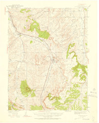 1940 Castle Rock1958 Print · USGSDouglas County ranching and rail life are captured here just before the mid-century, centered on the growing crossroads of Castle Rock. Genealogists can locate family-named landmarks and rural schools like Fonder Sch or trace the Bear Canyon Cem near Sedalia.3 unique versions available
 - 1945 Map of Castle Rock
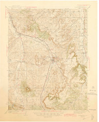 1945 Castle Rock1945 Print · USGSDouglas County's railway and ranching corridors come to life in the mid-1940s as two major railroads compete for space along the Plum Creek valley. Researchers can trace old family sites and rural institutions like the Pikes Peak Grange Hall, Bear Canyon Cem, and the Clay Mine.2 unique versions available
End of results
Showing maps 1-2 of 2
Top cities near Happy Canyon Ranches
- Aurora historical maps
- Lakewood historical maps
- Highlands Ranch historical maps
- Centennial historical maps
- Castle Rock historical maps
- Parker historical maps
See more
Frequently asked questions
- What are the different types of historical maps available for Happy Canyon Ranches?
- What is the oldest map of Happy Canyon Ranches?
- Where can I purchase historical maps of Happy Canyon Ranches for my home or office?
- Where can I download high-res historical maps of Happy Canyon Ranches?
- Are there historical topographic maps available for Happy Canyon Ranches?
- Is there historical aerial imagery available for Happy Canyon Ranches?
- Where are historical maps of Happy Canyon Ranches sourced from?