1980s Maps of Palmer Lake, Colorado
Explore 3 historic maps of Palmer Lake from the 1980s. These maps offer a rare glimpse into what life looked like during the 1980s — showing old roads, neighborhoods, homes, and landmarks that have changed or disappeared over time.
Whether you're researching your family's past, planning a metal detecting trip, or studying how Palmer Lake's landscape evolved across the 1980s, these high-resolution maps are a powerful tool for exploring the history of this region.
- Focus on a specific era: All maps on this page are from the 1980s, giving you a focused view of this time period.
- See what’s changed: Compare century-old streets, trails, and buildings to today's modern landscape using overlays and satellite layers.
- Research with precision: Use these maps for genealogy, historical research, land use analysis, or educational projects.
- View, download, or print: Maps are fully viewable online in high resolution, and can be downloaded or printed for your own records.
Start exploring Palmer Lake's history through authentic maps from the 1980s. This is your window into the past.
Palmer Lake, CO maps
(3)- 1983 Map of Castle Rock
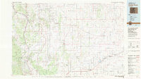 1983 Castle Rock1983 Print · USGSThe Palmer Divide and Front Range foothills come to life in the early eighties as ranching communities and military sites define the landscape. Trace old rail lines like the Chicago Rock Island and Pacific and find landmarks from Monkey Face to Daniels Park.
 - 1986 Map of Monument
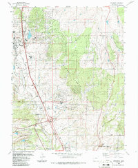 1986 Monument1986 Print · USGSIn the mid-1980s, the northern edge of the Air Force Academy meets the growing communities of Monument and Palmer Lake. Genealogists and historians can trace the local infrastructure from the Cem and Lewis Palmer Elem Sch to the military landmarks of the B-52 Exhibit.
 - 1986 Map of Palmer Lake
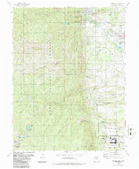 1986 Palmer Lake1986 Print · USGSIn the mid-1980s, the northern El Paso County landscape shows the interface of the United States Air Force Academy and the older mountain settlements. Researchers can trace the Denver and Rio Grande Western Railroad Grade and locate local landmarks like Elephant Rock and Monument Lake.
End of results
Showing maps 1-3 of 3
Top cities near Palmer Lake
- Colorado Springs historical maps
- Castle Rock historical maps
- Woodland Park historical maps
- Monument historical maps
- Green Mountain Falls historical maps
- Larkspur historical maps
Top neighborhoods of Palmer Lake
Frequently asked questions
- What are the different types of historical maps available for Palmer Lake?
- What is the oldest map of Palmer Lake?
- Where can I purchase historical maps of Palmer Lake for my home or office?
- Where can I download high-res historical maps of Palmer Lake?
- Are there historical topographic maps available for Palmer Lake?
- Is there historical aerial imagery available for Palmer Lake?
- Where are historical maps of Palmer Lake sourced from?