Old Maps of Tincup, Colorado for Academic Research
Study the evolution of Tincup with 13 high-resolution historic maps. Whether you're teaching, researching, or modeling changes in land use, these maps provide essential visual documentation of urban, environmental, and geographic change.
- Analyze long-term change: Track patterns in development, transportation, and natural features.
- Ideal for environmental or urban studies: Support academic projects with primary historical map data.
- Use in the classroom or lab: Educators and researchers rely on these maps to bring historical context to life.
These maps are a powerful tool for teaching, research, and visualizing how Tincup has changed over the decades.
Tincup, CO maps
(13)- 1955 Map of Mount Harvard, 1958 Print
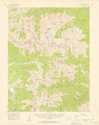 1955 Mount Harvard1958 Print · USGSThe high peaks of the Sawatch Range are captured here in the mid-1950s at the height of their mining and forest service era. Genealogists and historians can trace the remote settlements of Winfield, Vicksburg, and Tincup, or locate the Banker Mine and Magdalene Mine.4 unique versions available
 - 1956 Map of Montrose, 1963 Print
 1956 Montrose1963 Print · USGSThe Colorado western slope in the late fifties and early sixties shows a landscape defined by the Denver & Rio Grande Western RR and the Gunnison River. Trace the development of Blue Mesa Reservoir or locate high-country sites like the Bachelor Mine.3 unique versions available
 - 1959 Map of Montrose
 1959 Montrose1959 Print · USGSWestern Colorado in the late fifties is defined by the high peaks and river valleys of the Southern Rockies. Genealogists and historians can trace the paths of the Denver & Rio Grande Western RR or locate mountain settlements like Crawford, Lazear, and Doyleville.
 - 1960 Map of Montrose
 1960 Montrose1960 Print · USGSThe Colorado high country in the mid-fifties is captured here during a period of steady ranching and persistent mining. Researchers can trace the path of the Denver & Rio Grande Western RR or locate small settlements like Somerset, Maher, and Sargent.2 unique versions available
 - 1968 Map of Montrose
 1968 Montrose1968 Print · USGSThe Western Slope and Continental Divide meet in the late sixties, showing the vital river valleys and high-mountain mining districts. Trace the historic route of the Denver and Rio Grande Western RR or locate small settlements like Sargents and Powderhorn.
 - 1982 Map of Tincup, 1983 Print
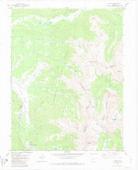 1982 Tincup1983 Print · USGSThe high-country mining district around Tincup is captured here during the early 1980s, straddling the Continental Divide. Researchers can locate numerous Mines, extensive Dredge Tailings, and high-altitude landmarks like Cottonwood Pass and Ptarmigan Lake.2 unique versions available
 - 1984 Map of Gunnison
 1984 Gunnison1984 Print · USGSHigh mountain passes and historic mining districts define this mid-eighties record of the central Colorado Rockies. Genealogists and historians can trace the foundations of Gunnison and Crested Butte or locate remote sites like St Elmo, Tincup, and Hancock.2 unique versions available
 - 1994 Map of Tincup, 2001 Print
 1994 Tincup2001 Print · USGSHigh in the Rockies during the mid-nineties, this map captures the transition of the Tincup area from a historic mining district to a wilderness destination. Trace old extraction sites through Dredge Tailings and Mines or follow the Timberline Trail across the Continental Divide.
 - 2011 Map of Tincup, 2011 Print
 2011 Tincup2011 Print · USGSCovers Tincup, including Abbeyville, Chaffee County, and other nearby areas
 - 2013 Map of Tincup, 2013 Print
 2013 Tincup2013 Print · USGSCovers Tincup, including Abbeyville, Chaffee County, and other nearby areas
 - 2016 Map of Tincup, 2016 Print
 2016 Tincup2016 Print · USGSCovers Tincup, including Abbeyville, Chaffee County, and other nearby areas
 - 2019 Map of Tincup, 2019 Print
 2019 Tincup2019 Print · USGSCovers Tincup, including Abbeyville, Chaffee County, and other nearby areas
 - 2022 Map of Tincup, 2022 Print
 2022 Tincup2022 Print · USGSHigh in the Sawatch Range during the early twenty-first century, this area shows the historic mining settlements and rugged alpine terrain of the Continental Divide. Trace old mountain routes and basin claims near Tincup, Abbeyville, and Cottonwood Pass.
End of results
Showing maps 1-13 of 13
Top cities near Tincup
Frequently asked questions
- What are the different types of historical maps available for Tincup?
- What is the oldest map of Tincup?
- Where can I purchase historical maps of Tincup for my home or office?
- Where can I download high-res historical maps of Tincup?
- Are there historical topographic maps available for Tincup?
- Is there historical aerial imagery available for Tincup?
- Where are historical maps of Tincup sourced from?