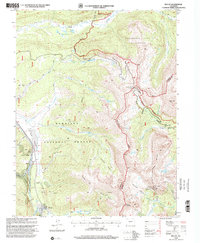
1994 Map of Tincup
USGS Topo · Published 2001About this map
The mining-era settlement of Tincup sits at the southern edge of this Colorado high country, surrounded by a landscape defined by its extractive history and alpine watersheds. The geography is dominated by the Continental Divide, which separates the Gunnison National Forest to the west from the San Isabel National Forest to the east. Extensive Dredge Tailings along Willow Creek and numerous unlabeled Mines and Prospects near Kentucky Gulch illustrate the heavy industrial footprint of the Tincup Mining District. High-altitude travel is traced through Cottonwood Pass and the long-distance Timberline Trail, which winds through the Collegiate Peaks Wilderness. The map reveals a transition from industrial exploitation to a preserved wilderness landscape, where prominent peaks like Mount Kreutzer and Ptarmigan Mountain tower over glacial basins such as Sanford Basin and Garden Basin.
Find a feature on this map
38 named features on this map. Tap any name to fly to it.
Don’t see what you’re looking for? This feature index may not catch every label — zoom into the map to look around manually.
Map Details
Editions of this 1994 Tincup Map
This is the sole edition of this map. No revisions or reprints were ever made.
Other maps of this area

1934 · Taylor Park
USGS Topo · 1:62,500

1937 · Taylor Park
USGS Topo · 1:62,500

1940 · Garfield
USGS Topo · 1:62,500

1941 · Pitkin
USGS Topo · 1:62,500

1945 · Pitkin
USGS Topo · 1:62,500

1945 · Garfield
USGS Topo · 1:62,500

1955 · Mount Harvard
USGS Topo · 1:62,500

1956 · Montrose
USGS Topo · 1:250,000

1959 · Montrose
USGS Topo · 1:250,000

1960 · Montrose
USGS Topo · 1:250,000