1910s Maps of Jackson County, Colorado
Explore 5 historic maps of Jackson County from the 1910s. These maps offer a rare glimpse into what life looked like during the 1910s — showing old roads, neighborhoods, homes, and landmarks that have changed or disappeared over time.
Whether you're researching your family's past, planning a metal detecting trip, or studying how Jackson County's landscape evolved across the 1910s, these high-resolution maps are a powerful tool for exploring the history of this region.
- Focus on a specific era: All maps on this page are from the 1910s, giving you a focused view of this time period.
- See what’s changed: Compare century-old streets, trails, and buildings to today's modern landscape using overlays and satellite layers.
- Research with precision: Use these maps for genealogy, historical research, land use analysis, or educational projects.
- View, download, or print: Maps are fully viewable online in high resolution, and can be downloaded or printed for your own records.
Start exploring Jackson County's history through authentic maps from the 1910s. This is your window into the past.
Jackson County, CO maps
(5)- 1911 Map of Hahns Peak, 1954 Print
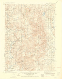 1911 Hahns Peak1954 Print · USGSThe northern Park Range and the Continental Divide appear in great detail just after the first decade of the twentieth century. Researchers can locate remote schools and ranches like Moon Hill School, the Elkhorn Mine, and the settlement of Pearl.2 unique versions available
 - 1913 Map of Hahns Peak
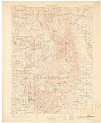 1913 Hahns Peak1913 Print · USGSRoutt County was a landscape of high-country mining and isolated homesteads in the early 1900s. Researchers can trace the era's rural infrastructure through old schoolhouses like Moon Hill School, the Elkhorn Mine, and settlements such as Columbine.2 unique versions available
 - 1915 Map of Longs Peak
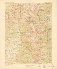 1915 Longs Peak1915 Print · USGSHigh mountain passes and early alpine settlements define this region just as the National Park system was taking root. Genealogists and hikers can trace the Ute Trail, locate the Sleepy Hollow School, or find the old Monarch PO near Grand Lake.3 unique versions available
 - 1916 Map of Home, 1954 Print
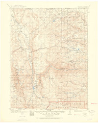 1916 Home1954 Print · USGSHigh mountain ranching and early forestry are captured in this 1916 survey of northern Colorado as the modern park system took root. Researchers can trace historic homesteads like Williams Ranch, find the Black Mtn School, and locate the mining-era settlement of Manhattan.2 unique versions available
 - 1919 Map of Rocky Mountain National Park
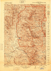 1919 Rocky Mountain National Park1919 Print · USGSThe high alpine basins of Northern Colorado are captured here in the years following the park's creation. Researchers can locate early schools and post offices like Sleepy Hollow School and Monarch PO, or trace the rail lines of the Denver and Salt Lake RR.7 unique versions available
End of results
Showing maps 1-5 of 5
Top cities of Jackson County
Frequently asked questions
- What are the different types of historical maps available for Jackson County?
- What is the oldest map of Jackson County?
- Where can I purchase historical maps of Jackson County for my home or office?
- Where can I download high-res historical maps of Jackson County?
- Are there historical topographic maps available for Jackson County?
- Is there historical aerial imagery available for Jackson County?
- Where are historical maps of Jackson County sourced from?