1990s Maps of Jefferson County, Colorado
Explore 11 historic maps of Jefferson County from the 1990s. These maps offer a rare glimpse into what life looked like during the 1990s — showing old roads, neighborhoods, homes, and landmarks that have changed or disappeared over time.
Whether you're researching your family's past, planning a metal detecting trip, or studying how Jefferson County's landscape evolved across the 1990s, these high-resolution maps are a powerful tool for exploring the history of this region.
- Focus on a specific era: All maps on this page are from the 1990s, giving you a focused view of this time period.
- See what’s changed: Compare century-old streets, trails, and buildings to today's modern landscape using overlays and satellite layers.
- Research with precision: Use these maps for genealogy, historical research, land use analysis, or educational projects.
- View, download, or print: Maps are fully viewable online in high resolution, and can be downloaded or printed for your own records.
Start exploring Jefferson County's history through authentic maps from the 1990s. This is your window into the past.
Jefferson County, CO maps
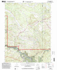
(11)- 1994 Map of Evergreen
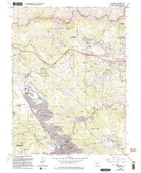 1994 Evergreen1994 Print · USGSThe Front Range communities of Jefferson County are captured here during the mid-nineties expansion. Researchers can trace the development of Evergreen and Kittredge, or locate local landmarks like the Rockland Cem and Hiwan Hills.
 - 1994 Map of Pine, 1998 Print
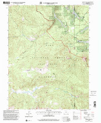
 1994 Pine1998 Print · USGSJefferson County mountain communities appear in detail during the 1990s as they interface with the Pike National Forest. Genealogists and historians can locate old homesites and landmarks like Shaffers Crossing, the Cemetery, and the Cathedral Spires.2 unique versions available
 - 1994 Map of Kassler, 1998 Print
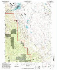 1994 Kassler1998 Print · USGSDouglas County and the edge of the Front Range come into sharp focus in the mid-nineties. Trace the water systems and settlement patterns around Kassler and Waterton, or locate the historic industrial sites at Louviers and the Clay Pits.
 - 1994 Map of Platte Canyon, 1998 Print
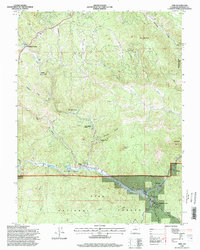
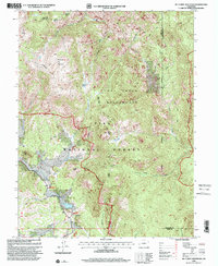
 1994 Platte Canyon1998 Print · USGSThe Jefferson County highlands and the confluence of the Platte rivers are captured here in the mid-1990s. Genealogists and hikers can locate the old community of Foxton, trace the Colorado Trail, and find landmarks like Reynolds Ranch.
 - 1994 Map of Deckers, 1998 Print
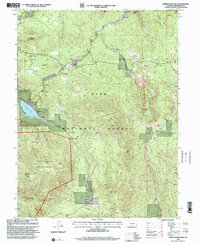
 1994 Deckers1998 Print · USGSThe South Platte River valley in the mid-1990s is captured here at a time when mountain settlements and forest outposts defined the landscape. Researchers can trace historical footprints at Long Scraggy Ranch, the riverside community of Deckers, and Snow Water Springs.
 - 1994 Map of Westcreek, 1998 Print
 1994 Westcreek1998 Print · USGSThe South Platte River corridor north of Westcreek comes into focus during the mid-nineties, documenting a landscape of forest camps and high peaks. Genealogists and historians can locate specific sites like Shady Brook Camp (YMCA), the Grandview Resort, and prominent landmarks including Thunder Butte.
 - 1994 Map of Bailey, 2001 Print
 1994 Bailey2001 Print · USGSThe North Fork South Platte River canyon in the 1990s shows a landscape of mountain settlements and national forest land. Genealogists and hikers can trace early sites like Deer Creek School, the Cem at Roland, and old railroad stops like Estabrook and Insmont.
 - 1994 Map of Windy Peak, 2001 Print
 1994 Windy Peak2001 Print · USGSPark County high country comes into focus in the 1990s as the wilderness and forest lands reach their modern boundaries. Researchers can trace historic ranch sites like Soderstrom Ranch and mountain landmarks including Windy Peak and The Castle.
 - 1994 Map of Mc Curdy Mountain, 2001 Print
 1994 Mc Curdy Mountain2001 Print · USGSThe high peaks and granite outcrops of the Colorado Front Range appear in detail during the mid-nineties. Hikers and historians can trace the Brookside McCurdy Trail past the Bearcat Mines and the old settlement of Spruce Grove.
 - 1994 Map of Green Mountain, 2001 Print
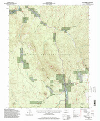
 1994 Green Mountain2001 Print · USGSThe high country of the Front Range comes into focus during the mid-nineties, showing the rugged interface of managed timber and protected peaks. Local historians and hikers can trace the Colorado Trail past Wellington Lake and through Buffalo Creek.2 unique versions available
 - 1994 Map of Cheesman Lake, 2001 Print
 1994 Cheesman Lake2001 Print · USGSThe Pike National Forest and the waters of the South Platte are surveyed here in the mid-1990s as they wind through Jefferson and Douglas counties. Researchers can locate established mountain retreats like Lost Valley Ranch and the Wigwam Club or trace the rugged drainages of Goose Creek and Schoonover Gulch.
End of results
Showing maps 1-11 of 11
Top cities of Jefferson County
- Lakewood historical maps
- Arvada historical maps
- Wheat Ridge historical maps
- Golden historical maps
- Evergreen historical maps
- Edgewater historical maps
See more
Frequently asked questions
- What are the different types of historical maps available for Jefferson County?
- What is the oldest map of Jefferson County?
- Where can I purchase historical maps of Jefferson County for my home or office?
- Where can I download high-res historical maps of Jefferson County?
- Are there historical topographic maps available for Jefferson County?
- Is there historical aerial imagery available for Jefferson County?
- Where are historical maps of Jefferson County sourced from?