1940s Maps of Kassler, Colorado
Explore 2 historic maps of Kassler from the 1940s. These maps offer a rare glimpse into what life looked like during the 1940s — showing old roads, neighborhoods, homes, and landmarks that have changed or disappeared over time.
Whether you're researching your family's past, planning a metal detecting trip, or studying how Kassler's landscape evolved across the 1940s, these high-resolution maps are a powerful tool for exploring the history of this region.
- Focus on a specific era: All maps on this page are from the 1940s, giving you a focused view of this time period.
- See what’s changed: Compare century-old streets, trails, and buildings to today's modern landscape using overlays and satellite layers.
- Research with precision: Use these maps for genealogy, historical research, land use analysis, or educational projects.
- View, download, or print: Maps are fully viewable online in high resolution, and can be downloaded or printed for your own records.
Start exploring Kassler's history through authentic maps from the 1940s. This is your window into the past.
Kassler, CO maps
(2)- 1945 Map of Kassler, 1956 Print
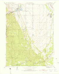 1945 Kassler1956 Print · USGSDouglas County and Jefferson County were shaped by water and rail at the end of the Second World War. Researchers can trace the Highline Canal and old rural schoolhouses like Jarre Canyon Sch or visit the once-active settlement of Kassler near the river.2 unique versions available
 - 1948 Map of Kassler
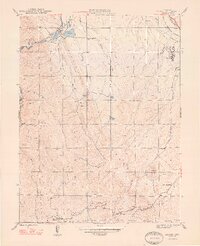 1948 Kassler1948 Print · USGSThe foothills of Douglas County appear here in the late 1940s, highlighting the vital water and rail corridors south of Denver. Genealogists and local historians can locate small rural schoolhouses like Jarre Canyon Sch and the rail station at Louviers.2 unique versions available
End of results
Showing maps 1-2 of 2
Top cities near Kassler
- Aurora historical maps
- Lakewood historical maps
- Highlands Ranch historical maps
- Centennial historical maps
- Castle Rock historical maps
- Littleton historical maps
See more
Frequently asked questions
- What are the different types of historical maps available for Kassler?
- What is the oldest map of Kassler?
- Where can I purchase historical maps of Kassler for my home or office?
- Where can I download high-res historical maps of Kassler?
- Are there historical topographic maps available for Kassler?
- Is there historical aerial imagery available for Kassler?
- Where are historical maps of Kassler sourced from?