Old Maps of Hermosa, Colorado for Metal Detecting
Plan your next treasure hunt with 18 historic maps of Hermosa. Find old homesites, ghost towns, trails, and gathering spots that may be lost to time — perfect for identifying promising metal detecting locations.
- Locate forgotten sites: Uncover places like long-lost settlements, abandoned rail lines, or gathering spots.
- Plan better hunts: Use map overlays combined with LiDAR or satellite views to narrow in on historically rich areas.
- Made for detectorists: Thousands of hobbyists use these maps to discover relics, coins, and hidden history.
Use these historic maps to boost your research and find new opportunities beneath the surface of Hermosa.
Hermosa, CO maps
(18)- 1898 Map of Durango
 1898 Durango1898 Print · USGSDurango at the close of the nineteenth century was a bustling rail and mining hub defined by its river valleys and mountain mills. Researchers can trace the early path of the Denver and Rio Grande R. R. and locate old sites like the Oro Fino Mill and Pinkerton Hot Springs.
 - 1907 Map of Durango, 1955 Print
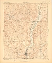
 1907 Durango1955 Print · USGSLa Plata County's mining and railroad era comes to life in this survey of the Animas River corridor. Trace the early path of the Rio Grande Southern R. R. and locate historic industrial sites like the Durango Smelter and the Neglected Mine.2 unique versions available
 - 1908 Map of Ignacio
 1908 Ignacio1908 Print · USGSLa Plata County and the Southern Ute lands are captured here in the first decade of the twentieth century. Genealogists and rail historians can trace the early growth of Durango and locate rural landmarks such as the Ute Indian Agency, Pinkerton Hot Springs, and the Oxford PO.3 unique versions available
 - 1908 Map of Durango
 1908 Durango1908 Print · USGSDurango and the Animas River valley are shown here at a peak of industrial activity in the early 1900s. Researchers can trace the narrow-gauge Denver and Rio Grande R. R. and locate specific sites like the Durango Smelter and Boston Coal Mine.3 unique versions available
 - 1924 Map of Ignacio, 1939 Print
 1924 Ignacio1939 Print · USGSLa Plata County during the mid-1920s reveals a landscape shaped by the Denver and Rio Grande Railroad and the carving of the Animas River. Researchers can trace the early layout of DURANGO, locate remote mountain schoolhouses like Little Red Sch, and identify historic boundaries such as the South Boundary Ceded Ute Land.4 unique versions available
 - 1945 Map of Durango
 1945 Durango1945 Print · USGSSouthwest Colorado and Northern New Mexico at mid-century are defined by the high peaks of the San Juan Range and the tribal lands of the Southern Ute. Genealogists and historians can trace the paths of the D & R G W RR and locate local landmarks like Animas City and the Blanco Basin School.3 unique versions available
 - 1953 Map of Durango, 1963 Print
 1953 Durango1963 Print · USGSThe high peaks of the San Juan Mountains and the Colorado mining country are shown here as they appeared in the early fifties. Genealogists and local historians can trace the rail lines of the D & R G W RR and locate historic mining camps like Silverton, Ouray, and Old Ophir.
 - 1954 Map of Durango
 1954 Durango1954 Print · USGSSouthern Colorado in the mid-1950s was defined by high-altitude mining towns and the expansion of water storage in the San Luis Valley. Trace the narrow-gauge Denver & Rio Grande Western RR as it connects Durango to mountain outposts like Silverton and Creede.2 unique versions available
 - 1961 Map of Durango
 1961 Durango1961 Print · USGSThe high San Juan country in the early sixties is shown here as a network of historic mining towns and early reservoir projects. Genealogists and researchers can trace the Denver & Rio Grande Western RR as it connects Durango, Silverton, and Arboles.
 - 1963 Map of Durango
 1963 Durango1963 Print · USGSThe San Juan Mountains and San Luis Valley are captured here in the early 1950s as mining, rail, and tribal lands shaped the region. Researchers can trace the Denver & Rio Grande Western RR through high-country towns like Telluride and Silverton, or locate landmarks such as the Asiatic Mine.
 - 1963 Map of Hermosa, 1965 Print
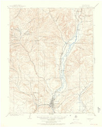
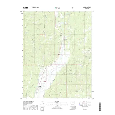
 1963 Hermosa1965 Print · USGSThe Animas River valley in the early sixties remains a landscape defined by its narrow-gauge rail lines and vital water ditches. Researchers can trace the Denver and Rio Grande Western through Rockwood and locate the Hermosa Cem near the riverbanks.5 unique versions available
 - 1966 Map of Durango
 1966 Durango1966 Print · USGSSouthwestern Colorado and the New Mexico borderlands are shown here in the mid-1960s, a time when the narrow-gauge rail network still tied the high peaks to the valley floor. Researchers can trace the Denver & Rio Grande Western Railroad between settlements like Silverton, Antonito, and Pagosa Springs.2 unique versions available
 - 1983 Map of Durango
 1983 Durango1983 Print · USGSSouthwestern Colorado at the start of the 1980s shows a landscape where high-mountain wilderness meets the agricultural plateaus of the Southern Ute. Genealogists and historians can trace the Durango & Silverton Narrow Gauge Railroad or locate sites like Southern Ute Agency and Pagosa Junction.
 - 2011 Map of Hermosa, 2011 Print
 2011 Hermosa2011 Print · USGSCovers Hermosa, including Rockwood, Trimble, and other nearby areas
 - 2013 Map of Hermosa, 2013 Print
 2013 Hermosa2013 Print · USGSCovers Hermosa, including Rockwood, Trimble, and other nearby areas
 - 2016 Map of Hermosa, 2016 Print
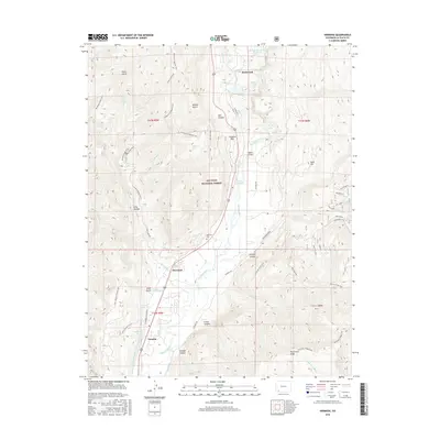 2016 Hermosa2016 Print · USGSCovers Hermosa, including Rockwood, Trimble, and other nearby areas
 - 2019 Map of Hermosa, 2019 Print
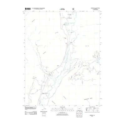
 2019 Hermosa2019 Print · USGSCovers Hermosa, including Rockwood, Trimble, and other nearby areas
 - 2022 Map of Hermosa, 2022 Print
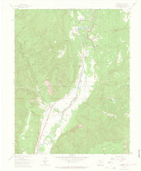
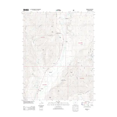
 2022 Hermosa2022 Print · USGSThe Animas River valley north of Durango is documented here during the early twenty-first century, showing the established settlements and thermal waters of La Plata County. Researchers can trace the layout of Hermosa, locate the Hermosa Cem, and identify geothermal sites like Pinkerton Hot Springs.
End of results
Showing maps 1-18 of 18
Top cities near Hermosa
Frequently asked questions
- What are the different types of historical maps available for Hermosa?
- What is the oldest map of Hermosa?
- Where can I purchase historical maps of Hermosa for my home or office?
- Where can I download high-res historical maps of Hermosa?
- Are there historical topographic maps available for Hermosa?
- Is there historical aerial imagery available for Hermosa?
- Where are historical maps of Hermosa sourced from?