1900-1909 Maps of Pinewood Springs, Colorado
Explore 2 historic maps of Pinewood Springs from 1900-1909. These maps offer a rare glimpse into what life looked like during the 1900s — showing old roads, neighborhoods, homes, and landmarks that have changed or disappeared over time.
Whether you're researching your family's past, planning a metal detecting trip, or studying how Pinewood Springs's landscape evolved across the 1900s, these high-resolution maps are a powerful tool for exploring the history of this region.
- Focus on a specific era: All maps on this page are from the 1900s, giving you a focused view of this time period.
- See what’s changed: Compare century-old streets, trails, and buildings to today's modern landscape using overlays and satellite layers.
- Research with precision: Use these maps for genealogy, historical research, land use analysis, or educational projects.
- View, download, or print: Maps are fully viewable online in high resolution, and can be downloaded or printed for your own records.
Start exploring Pinewood Springs's history through authentic maps from the 1900s. This is your window into the past.
Pinewood Springs, CO maps
(2)- 1905 Map of Mount Olympus, 1955 Print
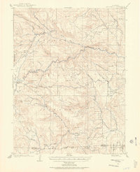 1905 Mount Olympus1955 Print · USGSLarimer County mountain life is captured here at the turn of the century as early ranching and tourism began to define the canyons. Genealogists and historians can trace family-held lands such as Pflums Ranch, stay at the Rustic Hotel, or locate the now-submerged site of Pinewood.2 unique versions available
 - 1907 Map of Mount Olympus
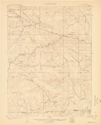 1907 Mount Olympus1907 Print · USGSLarimer County at the turn of the century shows a landscape of early cattle ranches and mountain retreats along the Thompson River. Genealogists can trace family holdings at the Plum's Ranch and Miners Ranch or locate the historic Rustic Hotel and Noland rail stop.4 unique versions available
End of results
Showing maps 1-2 of 2
Top cities near Pinewood Springs
- Fort Collins historical maps
- Boulder historical maps
- Longmont historical maps
- Loveland historical maps
- Estes Park historical maps
- Lyons historical maps
See more
Frequently asked questions
- What are the different types of historical maps available for Pinewood Springs?
- What is the oldest map of Pinewood Springs?
- Where can I purchase historical maps of Pinewood Springs for my home or office?
- Where can I download high-res historical maps of Pinewood Springs?
- Are there historical topographic maps available for Pinewood Springs?
- Is there historical aerial imagery available for Pinewood Springs?
- Where are historical maps of Pinewood Springs sourced from?