Old Maps of Spencer Heights, Colorado for Genealogy
Trace your family roots with 15 historic maps of Spencer Heights. These high-res maps reveal old neighborhoods, homesites, landmarks, and streets — helping you uncover where your ancestors lived and how the area evolved over time.
- Explore historic neighborhoods: Identify where your relatives may have lived in the 1800s or 1900s.
- Compare maps over time: Trace the changes in streets, buildings, and landmarks for multi-generational research.
- Perfect for genealogy & ancestry research: Used by family historians and researchers to map out lineage and migration.
These maps are an incredible resource for exploring your personal connection to Spencer Heights's past.
Spencer Heights, CO maps
(15)- 1916 Map of Home, 1954 Print
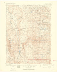 1916 Home1954 Print · USGSHigh mountain ranching and early forestry are captured in this 1916 survey of northern Colorado as the modern park system took root. Researchers can trace historic homesteads like Williams Ranch, find the Black Mtn School, and locate the mining-era settlement of Manhattan.2 unique versions available
 - 1920 Map of Home
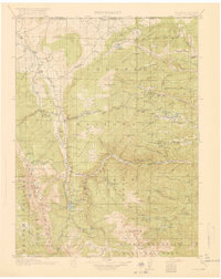 1920 Home1920 Print · USGSLarimer County at the end of the Great War was a landscape of high-country ranches and forest outposts. Genealogists and historians can locate family homesteads like Derby Ranch and Bennett Ranch or trace the early operations of the Black Mtn School and Manhattan.4 unique versions available
 - 1954 Map of Greeley, 1966 Print
 1954 Greeley1966 Print · USGSNorthern Colorado transitions from high-alpine peaks to the irrigated South Platte valley during this mid-century period of growth. Genealogists and historians can trace rail-connected hubs like Greeley and Longmont alongside landmarks like Horsetooth Reservoir and Estes Park.3 unique versions available
 - 1957 Map of Greeley
 1957 Greeley1957 Print · USGSNorthern Colorado in the mid-fifties is captured here as the agricultural plains of Weld County meet the high peaks of the Front Range. Genealogists and historians can trace rail-linked towns like Keenesburg and Roggen or locate early water features such as Boyd Lake and Fossil Creek Reservoir.
 - 1958 Map of Greeley
 1958 Greeley1958 Print · USGSNorthern Colorado and the high peaks of the Front Range appear here in the mid-fifties as the region's agricultural and rail networks were fully established. Genealogists can locate family homes near Virginia Dale, Waverly, or Kuner, and trace the path of the Union Pacific Railroad through Greeley.
 - 1961 Map of Greeley
 1961 Greeley1961 Print · USGSNorthern Colorado's transition from high mountain peaks to irrigated plains is captured here just as the post-war population boom reached the Front Range. Researchers can trace early water infrastructure and rail lines like the Great Western RR connecting sugar beet hubs from Fort Collins to Greeley.
 - 1962 Map of Boston Peak, 1964 Print
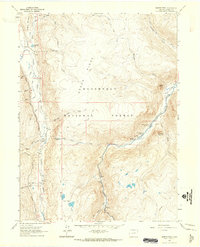 1962 Boston Peak1964 Print · USGSLarimer County high country in the early 1960s is defined by the intersection of mountain water projects and remote forest outposts. Trace the path of the Laramie-Poudre Tunnel or locate historic stops like Sportsman Lodge and Reds Place.4 unique versions available
 - 1964 Map of Greeley
 1964 Greeley1964 Print · USGSThe Front Range corridor and high peaks of the Rockies appear here in the mid-1960s, showing the intersection of mountain wilderness and plains agriculture. Trace the rail routes of the Great Western RR or locate landmarks like Longs Peak and Horsetooth Reservoir.
 - 1965 Map of Greeley
 1965 Greeley1965 Print · USGSNorthern Colorado in the mid-sixties shows a landscape defined by high mountain summits and the growing irrigation networks of the plains. Genealogists and historians can trace rail-side towns like Wellington or follow the early tracks of the Union Pacific Railroad past Longs Peak.
 - 1980 Map of Fort Collins, 1981 Print
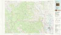 1980 Fort Collins1981 Print · USGSThe Front Range and high Rockies meet in Larimer County during the early 1980s. Local researchers can trace the growth of Fort Collins, the irrigation network around Wellington, and high-country outposts like Red Feather Lakes or the scenic canyon settlement of Mishawaka.
 - 2011 Map of Boston Peak, 2011 Print
 2011 Boston Peak2011 Print · USGSCovers Spencer Heights, including Larimer County, United States, and other nearby areas
 - 2013 Map of Boston Peak, 2013 Print
 2013 Boston Peak2013 Print · USGSCovers Spencer Heights, including Larimer County, United States, and other nearby areas
 - 2016 Map of Boston Peak, 2016 Print
 2016 Boston Peak2016 Print · USGSCovers Spencer Heights, including Larimer County, United States, and other nearby areas
 - 2019 Map of Boston Peak, 2019 Print
 2019 Boston Peak2019 Print · USGSCovers Spencer Heights, including Larimer County, United States, and other nearby areas
 - 2022 Map of Boston Peak, 2022 Print
 2022 Boston Peak2022 Print · USGSNorthern Larimer County and the high country of the Medicine Bow Mountains are shown in this contemporary study of public lands and river headwaters. Trace mountain access routes and water infrastructure near Spencer Heights, Liebey Park, and along the Laramie River.
End of results
Showing maps 1-15 of 15
Top cities near Spencer Heights
Frequently asked questions
- What are the different types of historical maps available for Spencer Heights?
- What is the oldest map of Spencer Heights?
- Where can I purchase historical maps of Spencer Heights for my home or office?
- Where can I download high-res historical maps of Spencer Heights?
- Are there historical topographic maps available for Spencer Heights?
- Is there historical aerial imagery available for Spencer Heights?
- Where are historical maps of Spencer Heights sourced from?