1900s (20th Century) Maps of Axial, Colorado
Explore 12 historic maps of Axial from the 1900s (20th Century). These maps offer a rare glimpse into what life looked like during the 1900s — showing old roads, neighborhoods, homes, and landmarks that have changed or disappeared over time.
Whether you're researching your family's past, planning a metal detecting trip, or studying how Axial's landscape evolved across the 1900s, these high-resolution maps are a powerful tool for exploring the history of this region.
- Focus on a specific era: All maps on this page are from the 1900s, giving you a focused view of this time period.
- See what’s changed: Compare century-old streets, trails, and buildings to today's modern landscape using overlays and satellite layers.
- Research with precision: Use these maps for genealogy, historical research, land use analysis, or educational projects.
- View, download, or print: Maps are fully viewable online in high resolution, and can be downloaded or printed for your own records.
Start exploring Axial's history through authentic maps from the 1900s. This is your window into the past.
Axial, CO maps
(12)- 1910 Map of Danforth Hills
 1910 Danforth Hills1910 Print · USGSNorthwest Colorado is surveyed here in the early 1900s, showing a landscape defined by the rugged Danforth Hills and the early ranching outposts of Routt and Rio Blanco counties. Genealogists can locate family holdings like Edinger's Ranch and Maudlin's Ranch or trace the early post offices at Lay PO and Hamilton PO.
 - 1912 Map of Axial, 1958 Print
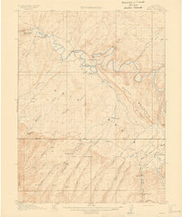
 1912 Axial1958 Print · USGSRanching life on Colorado's western slope is captured here just before the First World War, centered on the winding Yampa River. Genealogists can trace early homesteads like K Diamond Ranch and the settlement at Axial.
 - 1914 Map of Axial
 1914 Axial1914 Print · USGSMoffat County ranching and river life are captured here just before the First World War. Local historians can trace the early Meeker-area landscape through landmarks like Axial, the Juniper Hot Springs, and Duffy Mountain.3 unique versions available
 - 1954 Map of Craig, 1973 Print
 1954 Craig1973 Print · USGSNorthwest Colorado and the high mountain parks are captured in the mid-fifties, showing the region's ranching, mining, and timber centers. Genealogists and historians can trace rail corridors like the Denver and Rio Grande Western and old towns such as Axial, Milner, and Coalmont.3 unique versions available
 - 1957 Map of Craig
 1957 Craig1957 Print · USGSNorthwest Colorado in the mid-fifties is a landscape of mountain ranching and rail-dependent river towns. Researchers can trace historic coal mining at the Sudduth Mine, follow the Denver and Rio Grande Western tracks, and locate vanished settlements like Pearl.
 - 1958 Map of Craig
 1958 Craig1958 Print · USGSNorthwest Colorado and the High Rockies are captured here in the mid-fifties, showing a landscape of burgeoning water projects and mountain ranching. Genealogists and historians can trace old homesteads and mountain outposts from Grand Lake to Meeker, alongside industrial landmarks like Uranium Mines and the Denver and Rio Grande Western railroad.
 - 1960 Map of Craig
 1960 Craig1960 Print · USGSNorthwest Colorado in the 1950s is a landscape of mountain summits and industrial growth at the headwaters of the West. Genealogists and historians can trace rail-town development along the Denver and Salt Lake line, while locating Uranium Mines and settlements like Craig, Meeker, and Steamboat Springs.
 - 1962 Map of Craig
 1962 Craig1962 Print · USGSNorthwest Colorado in the early sixties is a land of high-elevation ranching and remote river valleys. Genealogists and historians can trace the Denver and Rio Grande Western rail lines and locate early settlements like Hahns Peak, Meeker, and Juniper Springs.
 - 1964 Map of Craig
 1964 Craig1964 Print · USGSNorthwestern Colorado's high country is captured here during the mid-sixties, from the Yampa River valley to the high peaks of the Park Range. Local researchers can trace the Denver and Rio Grande Western rail line and locate Uranium Mines near Lay.
 - 1965 Map of Craig
 1965 Craig1965 Print · USGSNorthwest Colorado in the mid-sixties is defined by its massive river basins and high mountain ranges flanking the Continental Divide. Trace the routes of the Denver and Rio Grande Western through old settlements like McCoy and Kremmling.
 - 1966 Map of Axial, 1970 Print
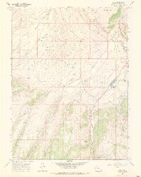 1966 Axial1970 Print · USGSMoffat County ranching and resource extraction are captured here during the 1960s, showing a landscape shaped by high-desert basins and isolated peaks. You can trace the lineage of local holdings at Wilson Ranch and Gossard Ranch or locate industrial sites like the Streeter Mine.2 unique versions available
 - 1979 Map of Meeker
 1979 Meeker1979 Print · USGSNorthwestern Colorado in the late seventies reveals a landscape of high-country wilderness and expanding energy production. Researchers can trace the Denver and Rio Grande Western RR as it serves the Energy Mine and Coal View Mine, or locate the Thornburgh Historical Site and Meeker Cemetery.
End of results
Showing maps 1-12 of 12
Top cities near Axial
Frequently asked questions
- What are the different types of historical maps available for Axial?
- What is the oldest map of Axial?
- Where can I purchase historical maps of Axial for my home or office?
- Where can I download high-res historical maps of Axial?
- Are there historical topographic maps available for Axial?
- Is there historical aerial imagery available for Axial?
- Where are historical maps of Axial sourced from?