1910s Maps of Axial, Colorado
Explore 3 historic maps of Axial from the 1910s. These maps offer a rare glimpse into what life looked like during the 1910s — showing old roads, neighborhoods, homes, and landmarks that have changed or disappeared over time.
Whether you're researching your family's past, planning a metal detecting trip, or studying how Axial's landscape evolved across the 1910s, these high-resolution maps are a powerful tool for exploring the history of this region.
- Focus on a specific era: All maps on this page are from the 1910s, giving you a focused view of this time period.
- See what’s changed: Compare century-old streets, trails, and buildings to today's modern landscape using overlays and satellite layers.
- Research with precision: Use these maps for genealogy, historical research, land use analysis, or educational projects.
- View, download, or print: Maps are fully viewable online in high resolution, and can be downloaded or printed for your own records.
Start exploring Axial's history through authentic maps from the 1910s. This is your window into the past.
Axial, CO maps
(3)- 1910 Map of Danforth Hills
 1910 Danforth Hills1910 Print · USGSNorthwest Colorado is surveyed here in the early 1900s, showing a landscape defined by the rugged Danforth Hills and the early ranching outposts of Routt and Rio Blanco counties. Genealogists can locate family holdings like Edinger's Ranch and Maudlin's Ranch or trace the early post offices at Lay PO and Hamilton PO.
 - 1912 Map of Axial, 1958 Print
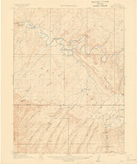
 1912 Axial1958 Print · USGSRanching life on Colorado's western slope is captured here just before the First World War, centered on the winding Yampa River. Genealogists can trace early homesteads like K Diamond Ranch and the settlement at Axial.
 - 1914 Map of Axial
 1914 Axial1914 Print · USGSMoffat County ranching and river life are captured here just before the First World War. Local historians can trace the early Meeker-area landscape through landmarks like Axial, the Juniper Hot Springs, and Duffy Mountain.3 unique versions available
End of results
Showing maps 1-3 of 3
Top cities near Axial
Frequently asked questions
- What are the different types of historical maps available for Axial?
- What is the oldest map of Axial?
- Where can I purchase historical maps of Axial for my home or office?
- Where can I download high-res historical maps of Axial?
- Are there historical topographic maps available for Axial?
- Is there historical aerial imagery available for Axial?
- Where are historical maps of Axial sourced from?