2020s Maps of Montrose, Colorado
Explore 4 historic maps of Montrose from the 2020s. These maps offer a rare glimpse into what life looked like during the 2020s — showing old roads, neighborhoods, homes, and landmarks that have changed or disappeared over time.
Whether you're researching your family's past, planning a metal detecting trip, or studying how Montrose's landscape evolved across the 2020s, these high-resolution maps are a powerful tool for exploring the history of this region.
- Focus on a specific era: All maps on this page are from the 2020s, giving you a focused view of this time period.
- See what’s changed: Compare century-old streets, trails, and buildings to today's modern landscape using overlays and satellite layers.
- Research with precision: Use these maps for genealogy, historical research, land use analysis, or educational projects.
- View, download, or print: Maps are fully viewable online in high resolution, and can be downloaded or printed for your own records.
Start exploring Montrose's history through authentic maps from the 2020s. This is your window into the past.
Montrose, CO maps
(4)- 2022 Map of Olathe, 2022 Print
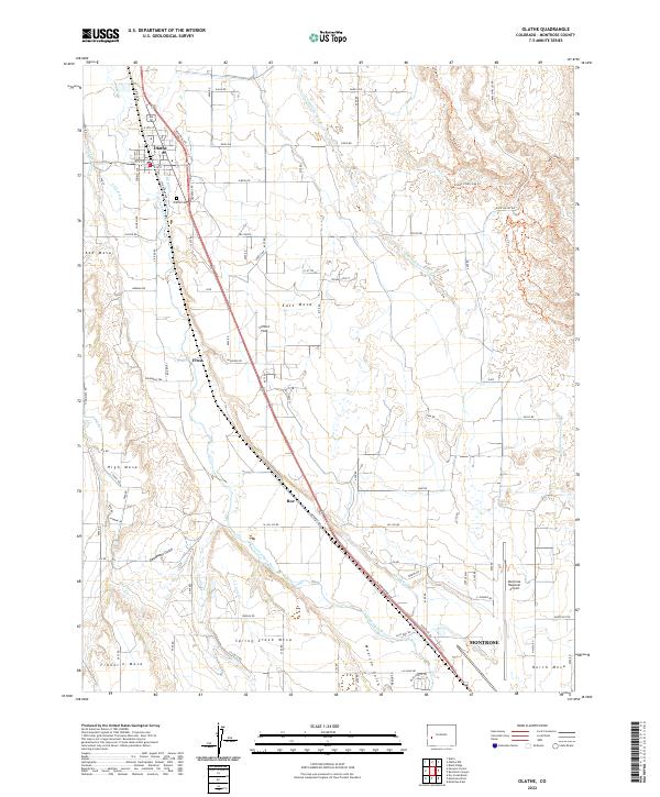 2022 Olathe2022 Print · USGSMontrose County's agricultural heartland is documented here in the early 2020s, showing the vital irrigation network of the Uncompahgre Valley. Researchers can trace land use across Ash Mesa, locate the Olathe Cem, and study the infrastructure of the Montrose Regional Airport.
 - 2022 Map of Montrose West, 2022 Print
 2022 Montrose West2022 Print · USGSThe western outskirts of Montrose are revealed in this modern survey, showing where the urban grid meets the agricultural mesas of the Uncompahgre Valley. Researchers can trace the development of Oak Grove and locate family sites at Grandview Cem or explore the drainage of Buzzard Gulch.
 - 2022 Map of Montrose East, 2022 Print
 2022 Montrose East2022 Print · USGSMontrose and the Uncompahgre River valley are shown here in the early 2020s as residential expansion meets agricultural tradition. Researchers can trace irrigation networks like the South Canal or locate local landmarks including Cedar Creek Cem and Kinikin Heights.
 - 2022 Map of Red Rock Canyon, 2022 Print
 2022 Red Rock Canyon2022 Print · USGSThe Uncompahgre Valley's high plateaus and deep canyons are documented here in the early twenty-first century as agricultural and recreational networks expand. Researchers can trace the path of the Loutsenhizer Canal or explore the rugged borders of Black Canyon of the Gunnison National Park.
End of results
Showing maps 1-4 of 4
Top cities near Montrose
Top neighborhoods of Montrose
Frequently asked questions
- What are the different types of historical maps available for Montrose?
- What is the oldest map of Montrose?
- Where can I purchase historical maps of Montrose for my home or office?
- Where can I download high-res historical maps of Montrose?
- Are there historical topographic maps available for Montrose?
- Is there historical aerial imagery available for Montrose?
- Where are historical maps of Montrose sourced from?