1970s Maps of Brush, Colorado
Explore 2 historic maps of Brush from the 1970s. These maps offer a rare glimpse into what life looked like during the 1970s — showing old roads, neighborhoods, homes, and landmarks that have changed or disappeared over time.
Whether you're researching your family's past, planning a metal detecting trip, or studying how Brush's landscape evolved across the 1970s, these high-resolution maps are a powerful tool for exploring the history of this region.
- Focus on a specific era: All maps on this page are from the 1970s, giving you a focused view of this time period.
- See what’s changed: Compare century-old streets, trails, and buildings to today's modern landscape using overlays and satellite layers.
- Research with precision: Use these maps for genealogy, historical research, land use analysis, or educational projects.
- View, download, or print: Maps are fully viewable online in high resolution, and can be downloaded or printed for your own records.
Start exploring Brush's history through authentic maps from the 1970s. This is your window into the past.
Brush, CO maps
(2)- 1971 Map of Brush East, 1984 Print
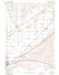 1971 Brush East1984 Print · USGSThe South Platte River valley in the early 1970s shows a landscape heavily shaped by irrigation and the rail lines. Researchers can trace the agricultural heart of the county through features like the Sugar Refinery, the Colwell School, and the winding Beaver Creek.2 unique versions available
 - 1971 Map of Brush West, 1984 Print
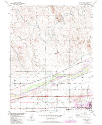 1971 Brush West1984 Print · USGSMorgan County in the early seventies shows a landscape defined by the South Platte River and the expansion of the town of Brush. Genealogists and historians can trace rail corridors, old schools like Colwell School, and landmarks such as Eben-Ezer Hospital.
End of results
Showing maps 1-2 of 2
Top cities near Brush
- Fort Morgan historical maps
- Log Lane Village historical maps
- Morgan Heights historical maps
- Hillrose historical maps
- Trail Side historical maps
- Saddle Ridge historical maps
See more
Frequently asked questions
- What are the different types of historical maps available for Brush?
- What is the oldest map of Brush?
- Where can I purchase historical maps of Brush for my home or office?
- Where can I download high-res historical maps of Brush?
- Are there historical topographic maps available for Brush?
- Is there historical aerial imagery available for Brush?
- Where are historical maps of Brush sourced from?