1900s (20th Century) Maps of Jefferson, Colorado
Explore 9 historic maps of Jefferson from the 1900s (20th Century). These maps offer a rare glimpse into what life looked like during the 1900s — showing old roads, neighborhoods, homes, and landmarks that have changed or disappeared over time.
Whether you're researching your family's past, planning a metal detecting trip, or studying how Jefferson's landscape evolved across the 1900s, these high-resolution maps are a powerful tool for exploring the history of this region.
- Focus on a specific era: All maps on this page are from the 1900s, giving you a focused view of this time period.
- See what’s changed: Compare century-old streets, trails, and buildings to today's modern landscape using overlays and satellite layers.
- Research with precision: Use these maps for genealogy, historical research, land use analysis, or educational projects.
- View, download, or print: Maps are fully viewable online in high resolution, and can be downloaded or printed for your own records.
Start exploring Jefferson's history through authentic maps from the 1900s. This is your window into the past.
Jefferson, CO maps
(9)- 1937 Map of Como
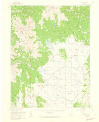
 1937 Como1937 Print · USGSPark County at the height of the mining era is captured here, centered on the high mountain passes and rail corridors. Genealogists and historians can trace the early footprints of Como, Jefferson, and the high-altitude Ute Mine or the remote Bakers Tank.3 unique versions available
 - 1953 Map of Denver, 1964 Print
 1953 Denver1964 Print · USGSDenver and the Colorado Front Range are captured here during a decade of post-war growth and military expansion. Researchers can trace the sprawling rail lines of the Union Pacific, locate the State Capitol, and explore historic mountain mining hubs like Central City.6 unique versions available
 - 1957 Map of Denver
 1957 Denver1957 Print · USGSDenver and the Colorado Front Range are seen here during a mid-century period of intense military and urban expansion. Trace the footprints of the Rocky Mountain Arsenal, the early United States Air Force Academy, and the Lowry AF Base.
 - 1958 Map of Denver
 1958 Denver1958 Print · USGSDenver and the Colorado Front Range are captured here during the mid-century suburban boom. Trace the footprints of military installations like Buckley Air Force Base alongside the established rail networks of the Colorado & Southern Ry.
 - 1958 Map of Jefferson, 1959 Print
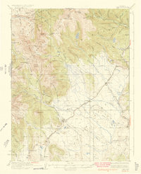
 1958 Jefferson1959 Print · USGSThe high alpine ranchlands of Park County come alive in the late 1950s as the high-country ranching era remains in full swing. Genealogists and historians can trace family properties like the Steiner Ranch or find remnants of the Old Railroad Grade and the Liesburg Homestead (Aband).7 unique versions available
 - 1958 Map of Como, 1960 Print
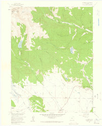
 1958 Como1960 Print · USGSPark County ranching and Summit County mining collide at the Continental Divide during the late fifties. Genealogists can trace family holdings from the Slash 6 Ranch to the Liesburg Homestead or locate the historic Parkville and Como town sites.4 unique versions available
 - 1960 Map of Denver
 1960 Denver1960 Print · USGSDenver and the Colorado Front Range are seen here at a pivotal moment of postwar expansion into the plains and foothills. Researchers can trace the mid-century rail network of the Denver & Rio Grande Western RR and locate historic institutional landmarks like Buckley Field and the Colorado School of Mines.
 - 1983 Map of Bailey
 1983 Bailey1983 Print · USGSPark County and the high Front Range are captured here during the early 1980s as traditional mountain settlements met new development patterns. Genealogists and researchers can trace the Denver and Rio Grande Western Railroad and old mountain hamlets like Bailey, Webster, and Garo.2 unique versions available
 - 1994 Map of Jefferson, 1998 Print
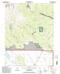 1994 Jefferson1998 Print · USGSThe high passes and ranching valleys of Park County are captured here in the mid-nineties, showing the intersection of the Continental Divide and the basin floor. Researchers can trace historic homesteads and family rangelands like Liesburg Homestead, Wahl Ranch, and 74 Ranch near the Colorado Trail.
End of results
Showing maps 1-9 of 9
Top cities near Jefferson
- Breckenridge historical maps
- Blue River historical maps
- Fairplay historical maps
- Montezuma historical maps
- Saints John historical maps
- Wild Irishman historical maps
Frequently asked questions
- What are the different types of historical maps available for Jefferson?
- What is the oldest map of Jefferson?
- Where can I purchase historical maps of Jefferson for my home or office?
- Where can I download high-res historical maps of Jefferson?
- Are there historical topographic maps available for Jefferson?
- Is there historical aerial imagery available for Jefferson?
- Where are historical maps of Jefferson sourced from?