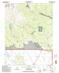
1994 Map of Jefferson
USGS Topo · Published 1998About this map
Continental Divide crests in the northwest corner of this high-country survey, marked by Whale Peak and the alpine waters of Gibson Lake. This landscape is defined by the headwaters of the North Fork Platte River and its numerous drainage gulches, including Handcart Gulch and Guernsey Gulch. Historically, the area represents a transition from high mountain passes to the ranching economy of the basin floor. Several family-named properties such as Steiner Ranch, Teter Ranch, and Schattinger Ranch anchor the southern valleys near Michigan Creek. In the upper elevations, the Pike National Forest shelters Lininger Lake and Jefferson Lake, while the Colorado Trail traverses the eastern slopes. A legacy of early settlement is visible at Hall Valley and the Liesburg Homestead, alongside markers like the Historical Monument (South Park) near Kenosha Pass.
Find a feature on this map
58 named features on this map. Tap any name to fly to it.
Don’t see what you’re looking for? This feature index may not catch every label — zoom into the map to look around manually.
Map Details
Editions of this 1994 Jefferson Map
This is the sole edition of this map. No revisions or reprints were ever made.
Other maps of this area

1903 · Georgetown
USGS Topo · 1:62,500

1905 · Georgetown
USGS Topo · 1:62,500

1924 · Montezuma
USGS Topo · 1:62,500

1926 · Montezuma
USGS Topo · 1:62,500

1933 · Montezuma
USGS Topo · 1:62,500

1937 · Como
USGS Topo · 1:62,500

1945 · Mount Logan
USGS Topo · 1:24,000

1948 · Mount Logan
USGS Topo · 1:24,000

1953 · Denver
USGS Topo · 1:250,000

1957 · Denver
USGS Topo · 1:250,000