
1948 Map of Mount Logan
USGS Topo · Published 1948About this map
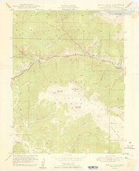
The North Fork South Platte River carves a deep valley through this mountain landscape, serving as the primary corridor for movement and settlement in the late 1940s. Small mountain communities including Webster, Grant, and Santa Maria are positioned along the river's edge, linked by the winding path of the Hoosier Trail. This map, produced in cooperation with the Denver Board of Water Commissioners, highlights the region's importance to the municipal water supply, with a network of high-altitude drainages like Geneva Creek and Rock Creek feeding into the main river fork.
Find a feature on this map
33 named features on this map. Tap any name to fly to it.
Don’t see what you’re looking for? This feature index may not catch every label — zoom into the map to look around manually.
Map Details
Editions of this 1948 Mount Logan Map
2 editions found
Other maps of this area

1903 · Georgetown
USGS Topo · 1:62,500

1905 · Georgetown
USGS Topo · 1:62,500

1924 · Montezuma
USGS Topo · 1:62,500

1926 · Montezuma
USGS Topo · 1:62,500

1933 · Montezuma
USGS Topo · 1:62,500

1937 · Como
USGS Topo · 1:62,500

1945 · Shawnee
USGS Topo · 1:24,000

1945 · Mount Logan
USGS Topo · 1:24,000

1948 · Shawnee
USGS Topo · 1:24,000

1953 · Denver
USGS Topo · 1:250,000