
1948 Map of Shawnee
USGS Topo · Published 1948About this map
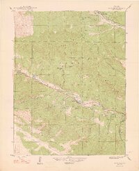
The North Fork South Platte River carves a central valley through this high-altitude landscape within the Pike National Forest. In the mid-1940s, the settlement pattern followed the river and the route of Highway 285, which links the small communities of Weller, Singleton, Shawnee, and Glenisle. This era shows the local infrastructure of rural life, including the Case School and the Willow Creek Ranch. The surrounding terrain is defined by a dense network of gulches and peaks named for early settlers and topographical features, such as Slaughterhouse Gulch, Derringer Peak, and Shawnee Peak. The map captures a moment when these mountain outposts served as critical stops along the canyon road, before the expansion of modern highway systems. To the north, the headwaters of Deer Creek and Crooked Top Mountain dominate the high ridges, illustrating the transition from ranching valleys to steep timbered slopes.
Find a feature on this map
33 named features on this map. Tap any name to fly to it.
Don’t see what you’re looking for? This feature index may not catch every label — zoom into the map to look around manually.
Map Details
Editions of this 1948 Shawnee Map
2 editions found
Other maps of this area

1893 · Platte Canyon
USGS Topo · 1:125,000

1899 · West Denver
USGS Topo · 1:125,000

1903 · Georgetown
USGS Topo · 1:62,500

1905 · Georgetown
USGS Topo · 1:62,500

1945 · Bailey
USGS Topo · 1:24,000

1945 · Shawnee
USGS Topo · 1:24,000

1945 · Mount Logan
USGS Topo · 1:24,000

1948 · Mount Logan
USGS Topo · 1:24,000

1949 · Bailey
USGS Topo · 1:24,000

1953 · Denver
USGS Topo · 1:250,000