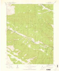
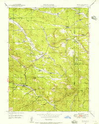
1945 Map of Shawnee
USGS Topo · Published 1957About this map
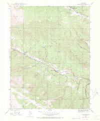
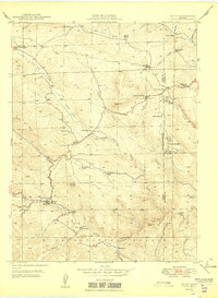
Shawnee and its neighboring valley settlements sit tucked along the North Fork South Platte River in the heart of the Pike National Forest. This 1945 survey captures a corridor of small mountain communities and ranches, including Weller, Singleton, and Glenisle, which were established along the primary road through the canyon. The landscape is defined by deep drainages like Slaughterhouse Gulch and Ben Tyler Gulch that feed the river from the surrounding Platte River Mountains. Evidence of early community infrastructure is visible at the Case School, while the presence of the Willow Creek Ranch suggests the area's agricultural and ranching roots. High peaks such as Derringer Peak and Shawnee Peak tower over the narrow river valley, providing a clear picture of the settlement patterns dictated by the steep Colorado terrain.
Find a feature on this map
31 named features on this map. Tap any name to fly to it.
Don’t see what you’re looking for? This feature index may not catch every label — zoom into the map to look around manually.
Map Details
Editions of this 1945 Shawnee Map
2 editions found
Other maps of this area

1893 · Platte Canyon
USGS Topo · 1:125,000

1899 · West Denver
USGS Topo · 1:125,000
1903 · Georgetown
USGS Topo · 1:62,500
1905 · Georgetown
USGS Topo · 1:62,500
1945 · Bailey
USGS Topo · 1:24,000
1945 · Mount Logan
USGS Topo · 1:24,000
1948 · Mount Logan
USGS Topo · 1:24,000
1948 · Shawnee
USGS Topo · 1:24,000
1949 · Bailey
USGS Topo · 1:24,000

1953 · Denver
USGS Topo · 1:250,000