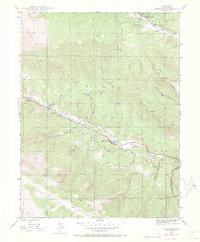
1945 Map of Shawnee
USGS Topo · Published 1972About this map
The North Fork South Platte River carves a central valley through this high-altitude landscape, dictating the placement of settlements and transport routes at the end of World War II. The community of Shawnee serves as a focal point along the river, surrounded by the vast timberlands of the Pike National Forest. Small mountain settlements and seasonal retreats like Glenisle, Highland Park, and Weller are linked by winding roads that follow the contours of the valley floor. To the south, the Platte River Mountains rise sharply, with Shawnee Peak overlooking the convergence of several deep drainages. Local landmarks such as the Case School and Willow Creek Ranch indicate a settled but sparse population reliant on the narrow corridors of the North Fork South Platte River for connectivity.
Find a feature on this map
30 named features on this map. Tap any name to fly to it.
Don’t see what you’re looking for? This feature index may not catch every label — zoom into the map to look around manually.
Map Details
Editions of this 1945 Shawnee Map
2 editions found
Other maps of this area

1893 · Platte Canyon
USGS Topo · 1:125,000

1899 · West Denver
USGS Topo · 1:125,000

1903 · Georgetown
USGS Topo · 1:62,500

1905 · Georgetown
USGS Topo · 1:62,500

1945 · Bailey
USGS Topo · 1:24,000

1945 · Shawnee
USGS Topo · 1:24,000

1945 · Mount Logan
USGS Topo · 1:24,000

1948 · Mount Logan
USGS Topo · 1:24,000

1948 · Shawnee
USGS Topo · 1:24,000

1949 · Bailey
USGS Topo · 1:24,000