1900s (20th Century) Maps of Pueblo, Colorado
Explore 14 historic maps of Pueblo from the 1900s (20th Century). These maps offer a rare glimpse into what life looked like during the 1900s — showing old roads, neighborhoods, homes, and landmarks that have changed or disappeared over time.
Whether you're researching your family's past, planning a metal detecting trip, or studying how Pueblo's landscape evolved across the 1900s, these high-resolution maps are a powerful tool for exploring the history of this region.
- Focus on a specific era: All maps on this page are from the 1900s, giving you a focused view of this time period.
- See what’s changed: Compare century-old streets, trails, and buildings to today's modern landscape using overlays and satellite layers.
- Research with precision: Use these maps for genealogy, historical research, land use analysis, or educational projects.
- View, download, or print: Maps are fully viewable online in high resolution, and can be downloaded or printed for your own records.
Start exploring Pueblo's history through authentic maps from the 1900s. This is your window into the past.
Pueblo, CO maps
(14)- 1904 Map of Nepesta
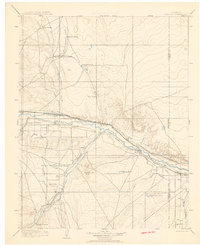 1904 Nepesta1904 Print · USGSEastern Colorado at the turn of the century shows a landscape transformed by water and rail. Trace the irrigation network of Excelsior Ditch and the lineage of family outposts like Skinner and Tabor Ranch and Tolle Ranch.3 unique versions available
 - 1954 Map of Pueblo, 1966 Print
 1954 Pueblo1966 Print · USGSMid-century Colorado comes alive in this survey of the Front Range and the high plains as the region expanded after the war. Genealogists and historians can trace family roots through rural landmarks like Hanover Church, Pioneer Cemetery, and the Grandview School.3 unique versions available
 - 1957 Map of Pueblo
 1957 Pueblo1957 Print · USGSMid-century Colorado comes alive as the Front Range urban centers expand alongside massive Cold War military installations. Genealogists and historians can trace the foundations of Stone City, rural sites like Hanover School, and the industrial Canon Imperial Mine.
 - 1958 Map of Pueblo
 1958 Pueblo1958 Print · USGSColorado's Front Range and Arkansas River Valley come alive in the late fifties, showing the transition from historic mining districts to major military and rail hubs. Genealogists and historians can trace family roots in ranching communities and find landmarks like Cripple Creek, Manitou, and the Hanover School.
 - 1960 Map of Devine, 1963 Print
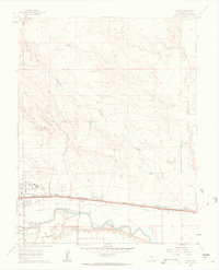 1960 Devine1963 Print · USGSThe Pueblo County desert meets the industrial rail corridor of the early 1960s, centered on the Arkansas River. Researchers can trace old railway alignments through Baxter and Devine or locate the sprawling grounds of the Pueblo Ordnance Depot.5 unique versions available
 - 1960 Map of Southeast Pueblo, 1963 Print
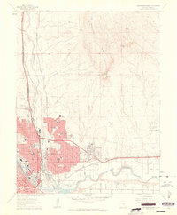
 1960 Southeast Pueblo1963 Print · USGSSoutheastern Pueblo is shown during a period of significant suburban and industrial growth in the early sixties. Researchers can trace the rail lines of the D & R G W or locate specific landmarks like Roselawn Cemetery and the community of Lombard Village.6 unique versions available
 - 1961 Map of Northwest Pueblo, 1962 Print
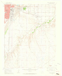
 1961 Northwest Pueblo1962 Print · USGSPueblo and its western outskirts are captured here in the early sixties as the city expanded along the river. Genealogists and local historians can trace the neighborhood footprints of Goodnight, the grounds of the State Fairground, and numerous local schools like Morton Sch.11 unique versions available
 - 1961 Map of Southwest Pueblo, 1963 Print
 1961 Southwest Pueblo1963 Print · USGSThe southwestern edge of Pueblo is captured here during the early sixties as suburban neighborhoods pushed into the high plains. Local historians can trace the foundations of the community through the State Fairgrounds, the Mountain View Cemetery, and the Old Railroad Grade.7 unique versions available
 - 1961 Map of Northeast Pueblo, 1963 Print
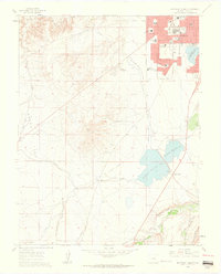
 1961 Northeast Pueblo1963 Print · USGSPueblo was entering a decade of significant growth when this survey recorded its shifting industrial and residential borders. Trace the city's mid-century expansion through names like Belmont, Fearnowville, and the grounds of the Pueblo Memorial Airport.7 unique versions available
 - 1962 Map of Pueblo
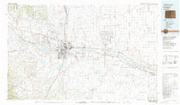
 1962 Pueblo1962 Print · USGSThe Front Range and high plains meet in the early sixties as military installations and industrial mining shape the corridor from Colorado Springs to Pueblo. Genealogists can trace family names through rural landmarks like the Columbine School, Hanover Church, and Fairview Cem.
 - 1966 Map of Pueblo
 1966 Pueblo1966 Print · USGSThe Front Range and Arkansas River Valley are captured here in the mid-1960s, showing a landscape shaped by mining, military expansion, and rail. Researchers can locate numerous country schools and mines, such as the Lytle School, Pioneer Cem, and Empire Zinc Mine.
 - 1981 Map of Pueblo
 1981 Pueblo1981 Print · USGSThe Arkansas River valley comes into sharp focus during the early eighties, showing the expansion of Pueblo and its rail networks. Researchers can trace historic sites like Fort Reynolds, explore the Pueblo Ordnance Depot, and locate family burial plots in Roselawn Cemetery.
 - 1989 Map of Pueblo
 1989 Pueblo1989 Print · USGSIn the late eighties, the Colorado Front Range balanced its deep mining history with massive military expansion and water development. Researchers can trace the rail lines of the AT & SF RR or locate remote high-altitude settlements like Rosita and Querida.
 - 1998 Map of Southwest Pueblo, 1999 Print
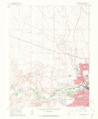
 1998 Southwest Pueblo1999 Print · USGSThe outskirts of Pueblo at the end of the century reveal a city expanding into the high plains. Genealogists and local historians can locate Mountain View Cemetery and trace landmarks like Beulah Heights Sch and the Old Railroad Grade.2 unique versions available
End of results
Showing maps 1-14 of 14
Top cities near Pueblo
Top neighborhoods of Pueblo
- Eden historical maps
- Fearnowville historical maps
- Baxter historical maps
- Northside historical maps
- Sunnyheights historical maps
- Aberdeen historical maps
See more
Frequently asked questions
- What are the different types of historical maps available for Pueblo?
- What is the oldest map of Pueblo?
- Where can I purchase historical maps of Pueblo for my home or office?
- Where can I download high-res historical maps of Pueblo?
- Are there historical topographic maps available for Pueblo?
- Is there historical aerial imagery available for Pueblo?
- Where are historical maps of Pueblo sourced from?