1980s Maps of Kerber City, Colorado
Explore 2 historic maps of Kerber City from the 1980s. These maps offer a rare glimpse into what life looked like during the 1980s — showing old roads, neighborhoods, homes, and landmarks that have changed or disappeared over time.
Whether you're researching your family's past, planning a metal detecting trip, or studying how Kerber City's landscape evolved across the 1980s, these high-resolution maps are a powerful tool for exploring the history of this region.
- Focus on a specific era: All maps on this page are from the 1980s, giving you a focused view of this time period.
- See what’s changed: Compare century-old streets, trails, and buildings to today's modern landscape using overlays and satellite layers.
- Research with precision: Use these maps for genealogy, historical research, land use analysis, or educational projects.
- View, download, or print: Maps are fully viewable online in high resolution, and can be downloaded or printed for your own records.
Start exploring Kerber City's history through authentic maps from the 1980s. This is your window into the past.
Kerber City, CO maps
(2)- 1980 Map of Bonanza, 1981 Print
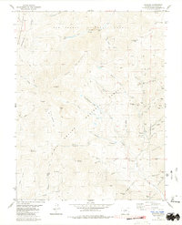 1980 Bonanza1981 Print · USGSBonanza was a thriving mining hub in the late twentieth century, centered at the meeting point of three National Forests. Genealogists and historians can trace the industrial footprint of the Rawley Mines, find old cemeteries, and locate the Little Bonanza Mill among the high peaks.3 unique versions available
 - 1982 Map of Saguache, 1983 Print
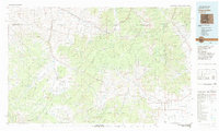 1982 Saguache1983 Print · USGSThe San Luis Valley meets the high peaks of the Sawatch Range in the early 1980s, revealing a landscape shaped by mining and rail. Researchers can trace the Denver and Rio Grande Western railroad and locate high-altitude sites like the Rawley Mine and the settlement of Bonanza.
End of results
Showing maps 1-2 of 2
Top cities near Kerber City
Frequently asked questions
- What are the different types of historical maps available for Kerber City?
- What is the oldest map of Kerber City?
- Where can I purchase historical maps of Kerber City for my home or office?
- Where can I download high-res historical maps of Kerber City?
- Are there historical topographic maps available for Kerber City?
- Is there historical aerial imagery available for Kerber City?
- Where are historical maps of Kerber City sourced from?