1970s Maps of Sedgwick County, Colorado
Explore 2 historic maps of Sedgwick County from the 1970s. These maps offer a rare glimpse into what life looked like during the 1970s — showing old roads, neighborhoods, homes, and landmarks that have changed or disappeared over time.
Whether you're researching your family's past, planning a metal detecting trip, or studying how Sedgwick County's landscape evolved across the 1970s, these high-resolution maps are a powerful tool for exploring the history of this region.
- Focus on a specific era: All maps on this page are from the 1970s, giving you a focused view of this time period.
- See what’s changed: Compare century-old streets, trails, and buildings to today's modern landscape using overlays and satellite layers.
- Research with precision: Use these maps for genealogy, historical research, land use analysis, or educational projects.
- View, download, or print: Maps are fully viewable online in high resolution, and can be downloaded or printed for your own records.
Start exploring Sedgwick County's history through authentic maps from the 1970s. This is your window into the past.
Sedgwick County, CO maps
(2)- 1972 Map of Lodgepole SE, 1975 Print
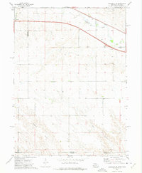 1972 Lodgepole SE1975 Print · USGSThe Nebraska-Colorado borderlands come into focus in the early 1970s, showing the intersection of interstate travel and historic rail. Researchers can trace the path of the Union Pacific along Lodgepole Creek or locate local landmarks like St Joseph Cem.
 - 1972 Map of Lodgepole SW, 1975 Print
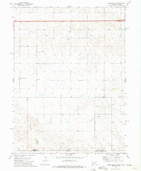 1972 Lodgepole SW1975 Print · USGSThe Nebraska-Colorado borderlands are captured here in the early 1970s, showing a remote agricultural landscape shaped by high plains drainages. Genealogists can locate specific burial sites like Czech Slovensky Cem and Swankee Cem near the seasonal banks of Cow Creek.
End of results
Showing maps 1-2 of 2
Top cities of Sedgwick County
Frequently asked questions
- What are the different types of historical maps available for Sedgwick County?
- What is the oldest map of Sedgwick County?
- Where can I purchase historical maps of Sedgwick County for my home or office?
- Where can I download high-res historical maps of Sedgwick County?
- Are there historical topographic maps available for Sedgwick County?
- Is there historical aerial imagery available for Sedgwick County?
- Where are historical maps of Sedgwick County sourced from?