1980s Maps of Yuma County, Colorado
Explore 2 historic maps of Yuma County from the 1980s. These maps offer a rare glimpse into what life looked like during the 1980s — showing old roads, neighborhoods, homes, and landmarks that have changed or disappeared over time.
Whether you're researching your family's past, planning a metal detecting trip, or studying how Yuma County's landscape evolved across the 1980s, these high-resolution maps are a powerful tool for exploring the history of this region.
- Focus on a specific era: All maps on this page are from the 1980s, giving you a focused view of this time period.
- See what’s changed: Compare century-old streets, trails, and buildings to today's modern landscape using overlays and satellite layers.
- Research with precision: Use these maps for genealogy, historical research, land use analysis, or educational projects.
- View, download, or print: Maps are fully viewable online in high resolution, and can be downloaded or printed for your own records.
Start exploring Yuma County's history through authentic maps from the 1980s. This is your window into the past.
Yuma County, CO maps
(2)- 1981 Map of Wray, 1982 Print
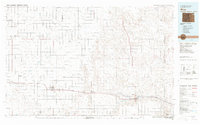 1981 Wray1982 Print · USGSThe high plains at the meeting of Colorado, Nebraska, and Kansas are documented here in the early 1980s. Local researchers can trace the Burlington Northern rail corridor and locate rural landmarks like Lone Star, Glocken Hill, and Dearing Lake.
 - 1983 Map of Bonny Reservoir, 1984 Print
 1983 Bonny Reservoir1984 Print · USGSThe high plains of eastern Colorado and western Kansas appear here in the early eighties, centered on the vital waters of Bonny Reservoir. Genealogists and local historians can trace small prairie settlements like Idalia, Kirk, and the historic site of Beecher Island.
End of results
Showing maps 1-2 of 2
Top cities of Yuma County
Frequently asked questions
- What are the different types of historical maps available for Yuma County?
- What is the oldest map of Yuma County?
- Where can I purchase historical maps of Yuma County for my home or office?
- Where can I download high-res historical maps of Yuma County?
- Are there historical topographic maps available for Yuma County?
- Is there historical aerial imagery available for Yuma County?
- Where are historical maps of Yuma County sourced from?