1970s Maps of Yuma, Colorado
Explore 2 historic maps of Yuma from the 1970s. These maps offer a rare glimpse into what life looked like during the 1970s — showing old roads, neighborhoods, homes, and landmarks that have changed or disappeared over time.
Whether you're researching your family's past, planning a metal detecting trip, or studying how Yuma's landscape evolved across the 1970s, these high-resolution maps are a powerful tool for exploring the history of this region.
- Focus on a specific era: All maps on this page are from the 1970s, giving you a focused view of this time period.
- See what’s changed: Compare century-old streets, trails, and buildings to today's modern landscape using overlays and satellite layers.
- Research with precision: Use these maps for genealogy, historical research, land use analysis, or educational projects.
- View, download, or print: Maps are fully viewable online in high resolution, and can be downloaded or printed for your own records.
Start exploring Yuma's history through authentic maps from the 1970s. This is your window into the past.
Yuma, CO maps
(2)- 1972 Map of Yuma South, 1975 Print
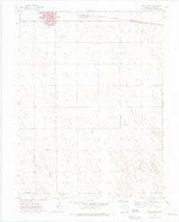 1972 Yuma South1975 Print · USGSThe town of Yuma enters the 1970s as a thriving agricultural and transportation hub on the Colorado plains. Genealogists and historians can trace the town's development through landmarks like Lake Yuma, the High Sch, and the Burlington Northern rail line.4 unique versions available
 - 1972 Map of Yuma North, 1975 Print
 1972 Yuma North1975 Print · USGSThe northern edge of Yuma, Colorado, appears as a developing agricultural hub in the early seventies, just as the regional infrastructure was modernizing. Researchers can trace the town's expansion around the Fairground and Golf Course, or locate the historic Cem.
End of results
Showing maps 1-2 of 2
Top cities near Yuma
Top neighborhoods of Yuma
Frequently asked questions
- What are the different types of historical maps available for Yuma?
- What is the oldest map of Yuma?
- Where can I purchase historical maps of Yuma for my home or office?
- Where can I download high-res historical maps of Yuma?
- Are there historical topographic maps available for Yuma?
- Is there historical aerial imagery available for Yuma?
- Where are historical maps of Yuma sourced from?