Old Maps of Easton, Connecticut for Hiking & Exploration
Hike through history with 48 historic maps of Easton. Explore old trails, ghost towns, and forgotten backroads — perfect for outdoor adventurers and local explorers.
- Rediscover forgotten places: Map out old mining camps, roads, and footpaths that no longer exist on modern maps.
- Layer with modern tools: Combine with LiDAR or satellite views to plan hikes through historical terrain.
- Made for exploration: Popular among hikers, overlanders, and local history lovers.
Use these maps to find adventure and explore the hidden past of Easton.
Easton, CT maps
(48)- 1889 Map of Derby
 1889 Derby1889 Print · USGSThe industrial Naugatuck Valley hums with activity in the late Victorian era as railroads and river power drive the growth of Connecticut's mill towns. Genealogists can trace family holdings near John Johnson Hill or explore the early street layouts of BIRMINGHAM, ANSONIA, and SEYMOUR.
 - 1891 Map of Bridgeport
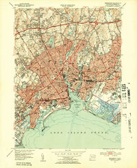
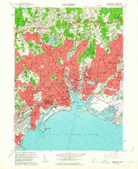
 1891 Bridgeport1891 Print · USGSThe industrial shoreline of Fairfield County comes to life in this late Victorian survey, capturing the region's intense rail and maritime activity. Trace the early street grids of Bridgeport and Milford, or locate family landmarks near Moodys Mill Pond and Nichols Farms.
 - 1891 Map of Derby
 1891 Derby1891 Print · USGSThe industrial Naugatuck Valley and the rural hills of Oxford come to life in the late nineteenth century. Genealogists and historians can trace the early footprints of Birmingham, Ansonia, and Derby or locate outlying hamlets like Quaker Farms and Red City.
 - 1892 Map of Danbury
 1892 Danbury1892 Print · USGSFairfield County thrived as a railroad and industrial hub in the late nineteenth century. Genealogists and researchers can trace old neighborhoods in Danbury and Bethel, or locate landmarks like the Putnam Monument and Sandy Hook Station.11 unique versions available
 - 1892 Map of Norwalk
 1892 Norwalk1892 Print · USGSThe Fairfield County coastline and its rural hinterlands are seen here in the late nineteenth century, showing the early density of harbor towns and scattered ridge-top farms. Genealogists can trace family lands near Greenfield Hill or follow the rails to the Five Mile River Sta. and Winnipauk.
 - 1893 Map of Bridgeport
 1893 Bridgeport1893 Print · USGSCoastal Connecticut thrived in the 1890s as a hub of manufacturing and rail transport. Genealogists and historians can trace the early street grids of Bridgeport, find old landmarks like Berkshire Mill Pond, and locate family sites in Nichols Farms.8 unique versions available
 - 1893 Map of Norwalk
 1893 Norwalk1893 Print · USGSThe Connecticut coastline thrives in the 1890s as a hub of rail transit and maritime trade. Genealogists and local researchers can trace old family landmarks across Belden Hill, the historic centers of Norwalk, and the early stops of the Danbury and Norwalk R.R.12 unique versions available
 - 1893 Map of Derby, 1898 Print
 1893 Derby1898 Print · USGSLower Naugatuck Valley industry and rural hill towns are captured in detail during the 1890s as the rail network reached its peak. Researchers can trace the industrial hearts of Birmingham and Derby or locate old crossings like Zoar Bridge and Pines Bridge.9 unique versions available
 - 1915 Map of Danbury, 1921 Print
 1915 Danbury1921 Print · USGSFairfield County in the early twentieth century was a hub of railway activity and village life. Genealogists and historians can trace the tracks of the Housatonic Railroad and locate local landmarks like the Fair Grounds or the Putnam Monument.
 - 1920 Map of Bridgeport
 1920 Bridgeport1920 Print · USGSCoastal Connecticut comes alive in the early twentieth century as a hub of maritime commerce and industrial growth. Researchers can trace the development of Bridgeport and Milford, or locate specific landmarks like Charles Island and Beardsley Park.
 - 1943 Map of Botsford
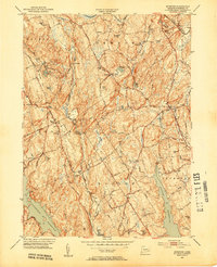
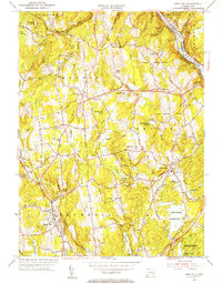
 1943 Botsford1943 Print · USGSFairfield County towns like Botsford and Stepney appear here during the early years of the war, showcasing a landscape of ridge-top villages and new reservoirs. Genealogists and historians can trace rail connections at Botsford Sta or locate family sites near Hattertown and Redding Ridge.
 - 1947 Map of Long Hill
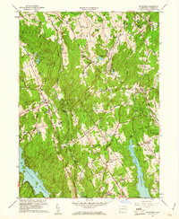
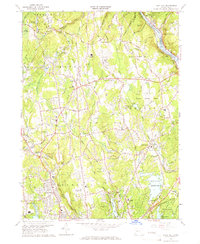
 1947 Long Hill1947 Print · USGSFairfield County towns and river valleys are captured here in the years following the war. Genealogists and local historians can trace the rail lines through Long Hill and Stepney or locate landmarks like Monroe and Trap Falls Reservoir.2 unique versions available
 - 1947 Map of Hartford, 1955 Print
 1947 Hartford1955 Print · USGSSouthern New England and the Hudson Valley are shown in detail during the post-war expansion era. Genealogists and researchers can trace local landmarks from the State Capitol and Yale University to the Stratford Lighthouse and Woodlawn Cem.2 unique versions available
 - 1948 Map of Hartford
 1948 Hartford1948 Print · USGSSouthern New England is captured here in the late 1940s, showcasing a landscape of thriving industrial cities and developing parkways. Genealogists and historians can trace the rail networks of the New York New Haven and Hartford RR or locate coastal defense sites like Fort Terry and Camp Shanks.2 unique versions available
 - 1951 Map of Westport, 1952 Print
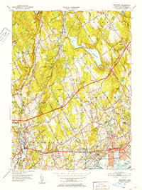 1951 Westport1952 Print · USGSFairfield and Westport appear here in the early fifties, showing a refined coastal landscape of established estates and watershed reservoirs. Genealogists and researchers can locate several burial grounds, including Gilbertown Cem and Old West Cem, alongside early academic sites like Fairfield University.5 unique versions available
 - 1951 Map of Botsford, 1953 Print
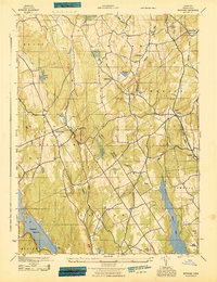
 1951 Botsford1953 Print · USGSFairfield County towns like Botsford and Easton appear in the early fifties as a landscape of traditional villages and vital water infrastructure. Genealogists and historians can trace family-named landmarks like Codfish Hill or locate old community hubs such as Hopewell School and St Patricks Ch.3 unique versions available
 - 1951 Map of Bridgeport, 1953 Print
 1951 Bridgeport1953 Print · USGSCoastal Connecticut comes into focus during the early fifties, showing the industrial density of Bridgeport and the developing suburbs of Stratford. Researchers can trace the city’s footprint from Mountain Grove Cemetery to the Bridgeport Municipal Airport.3 unique versions available
 - 1953 Map of Long Hill, 1955 Print
 1953 Long Hill1955 Print · USGSFairfield County's interior settlements and reservoir systems are captured in the early 1950s before significant modern expansion. Researchers can trace ancestral sites like Cutlers Farm Cem, find the old Monroe Sch, and locate the New York New Haven and Hartford RR along the Housatonic River.2 unique versions available
 - 1959 Map of Botsford, 1961 Print
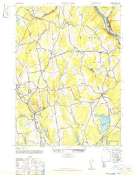
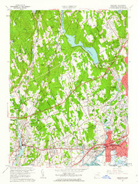
 1959 Botsford1961 Print · USGSFairfield County in the late fifties shows a landscape of growing reservoirs and historic hill settlements. Genealogists and historians can locate family landmarks like Morgan Cem and Huntingtown Cem or trace the early paths of Limekiln Road and Sport Hill Road.2 unique versions available
 - 1960 Map of Westport, 1962 Print
 1960 Westport1962 Print · USGSFairfield and Westport appear here during the mid-century expansion of coastal Connecticut. Researchers can trace the infrastructure of the New York New Haven and Hartford Railroad and locate community anchors like Fairfield University and Aspetuck Cem.5 unique versions available
 - 1960 Map of Bridgeport, 1963 Print
 1960 Bridgeport1963 Print · USGSCoastal Connecticut thrived during the post-war era as industrial hubs like Bridgeport and Stratford expanded along the sound. Researchers can find deep local roots in Mountain Grove Cemetery, trace the old New York New Haven and Hartford rail lines, or locate vanished landmarks near Pleasure Beach.
 - 1961 Map of Hartford
 1961 Hartford1961 Print · USGSSouthern New England and the Hudson Valley are shown here in the mid-fifties, capturing a landscape of booming coastal cities and interior hill towns. Researchers can trace the legacy of the New York New Haven and Hartford rail corridor and find strategic sites like Camp Shanks and Fort Michie.
 - 1962 Map of Hartford, 1971 Print
 1962 Hartford1971 Print · USGSSouthern New England and the Hudson Valley are shown in the early sixties, as suburban growth reached into the foothills. Trace the path of the New York New Haven & Hartford RR and find landmarks like Camp Nathan Hale and Gillette Castle State Park.3 unique versions available
 - 1964 Map of Long Hill, 1967 Print
 1964 Long Hill1967 Print · USGSFairfield County towns like Monroe and Huntington are shown here during the mid-1960s, reflecting a mix of rural heritage and suburban growth. Researchers can trace local history through Tungsten Mine Park, the Cutlers Farm Cem, and the Monroe Airport.3 unique versions available
 - 1965 Map of Hartford
 1965 Hartford1965 Print · USGSSouthern New England and the Hudson Valley are shown here during the mid-sixties expansion of the Interstate era. Trace the path of the New York New Haven & Hartford RR or locate historic landmarks like West Point Military Reservation and the Merritt Parkway.2 unique versions available
Showing maps 1-25 of 48
Top cities near Easton
- Brookhaven historical maps
- Bridgeport historical maps
- Stamford historical maps
- Norwalk historical maps
- Danbury historical maps
- Fairfield historical maps
See more
Top neighborhoods of Easton
Frequently asked questions
- What are the different types of historical maps available for Easton?
- What is the oldest map of Easton?
- Where can I purchase historical maps of Easton for my home or office?
- Where can I download high-res historical maps of Easton?
- Are there historical topographic maps available for Easton?
- Is there historical aerial imagery available for Easton?
- Where are historical maps of Easton sourced from?