1940s Maps of Thompson, Connecticut
Explore 8 historic maps of Thompson from the 1940s. These maps offer a rare glimpse into what life looked like during the 1940s — showing old roads, neighborhoods, homes, and landmarks that have changed or disappeared over time.
Whether you're researching your family's past, planning a metal detecting trip, or studying how Thompson's landscape evolved across the 1940s, these high-resolution maps are a powerful tool for exploring the history of this region.
- Focus on a specific era: All maps on this page are from the 1940s, giving you a focused view of this time period.
- See what’s changed: Compare century-old streets, trails, and buildings to today's modern landscape using overlays and satellite layers.
- Research with precision: Use these maps for genealogy, historical research, land use analysis, or educational projects.
- View, download, or print: Maps are fully viewable online in high resolution, and can be downloaded or printed for your own records.
Start exploring Thompson's history through authentic maps from the 1940s. This is your window into the past.
Thompson, CT maps
(8)- 1943 Map of Quinsigamond
 1943 Quinsigamond1943 Print · USGSCentral Massachusetts and its bordering states appear here during the Second World War as a powerhouse of rail infrastructure and public institutions. Researchers can trace the legacy of the region through landmarks like Grafton State Hospital, the Wachusett Reservoir, and the deep industrial roots of the Blackstone River.
 - 1943 Map of Putnam, 1944 Print
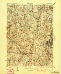
 1943 Putnam1944 Print · USGSThe Connecticut and Rhode Island borderlands are captured here during the wartime era, showing a landscape defined by textile river towns and sprawling state forests. Trace the industrial rail corridor of the New York New Haven and Hartford through Putnam, Danielson, and Moosup.
 - 1945 Map of Webster
 1945 Webster1945 Print · USGSThe borderlands of Massachusetts and Connecticut come alive in this mid-century survey of a thriving industrial river valley. Researchers can trace the heritage of mill towns and educational landmarks like Nichols College, West Dudley, and Perryville.2 unique versions available
 - 1945 Map of Putnam
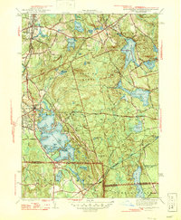
 1945 Putnam1945 Print · USGSWindham County at the close of the Second World War shows a landscape of busy river towns and prominent private academies. Researchers can trace the New York New Haven and Hartford rail line past Putnam Academy and Annhurst College.2 unique versions available
 - 1946 Map of Oxford
 1946 Oxford1946 Print · USGSThe Massachusetts and Rhode Island borderlands are captured here in the mid-forties, showing the complex shorelines of Lake Chaubunagungamaug. Researchers can trace the CENTRAL TURNPIKE, early lakeside colonies at Colonial Park, and the wooded expanse of the Douglas Cedar Swamp.2 unique versions available
 - 1947 Map of Providence, 1948 Print
 1947 Providence1948 Print · USGSSouthern New England is captured in the mid-1940s, showing a landscape defined by busy industrial ports and expanding military installations. Researchers can trace the rail lines of the N.Y. N.H. & H. RR or locate coastal defenses like Fort Adams and Quonset Point.5 unique versions available
 - 1948 Map of Boston
 1948 Boston1948 Print · USGSEastern Massachusetts and southern New Hampshire appear at an industrial peak in the late 1940s, just as suburban growth began to accelerate. Genealogists and historians can trace rail lines like the Boston and Albany RR or locate coastal landmarks like Graves Lighthouse and Fort Devens.2 unique versions available
 - 1948 Map of Providence, 1951 Print
 1948 Providence1951 Print · USGSSouthern New England’s coastal reaches are captured here in the late 1940s, from the industrial heart of Providence to the tip of Provincetown. Genealogists and historians can trace rail lines like the Central Vermont Railway and locate active military sites such as Otis Air Force Base and Fort Rodman.
End of results
Showing maps 1-8 of 8
Top cities near Thompson
- Webster historical maps
- Grafton historical maps
- Killingly historical maps
- Southbridge historical maps
- Northbridge historical maps
- Auburn historical maps
See more
Top neighborhoods of Thompson
- North Grosvenordale historical maps
- West Thompson historical maps
- Quaddick historical maps
- Fabyan historical maps
- Grosvenordale historical maps
- Mechanicsville historical maps
See more
Frequently asked questions
- What are the different types of historical maps available for Thompson?
- What is the oldest map of Thompson?
- Where can I purchase historical maps of Thompson for my home or office?
- Where can I download high-res historical maps of Thompson?
- Are there historical topographic maps available for Thompson?
- Is there historical aerial imagery available for Thompson?
- Where are historical maps of Thompson sourced from?