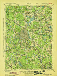
1943 Map of Quinsigamond
USGS Topo · Published 1943About this map
The Wachusett Reservoir dominates the northern landscape of this wartime survey, acting as a massive hydrologic centerpiece for a region defined by industrial river valleys and numerous glacial ponds. The industrial character of the era is evidenced by the density of the rail network, where the Boston & Maine RR, New York Central RR, and New York New Haven & Hartford RR converge on Worcester and its surrounding mill towns. Beyond the urban centers, the map reveals a landscape dedicated to public institutions and preservation, from the Grafton State Hospital and Central New England Sanatorium to the recreational and geological interest of Purgatory Chasm. Military readiness is noted at Fort Devens to the north, while smaller aviation sites like Mendon Airport and Grafton Airport represent the growing utility of local airfields during the mid-20th century.
Find a feature on this map
340 named features on this map. Tap any name to fly to it.
Don’t see what you’re looking for? This feature index may not catch every label — zoom into the map to look around manually.
Map Details
Editions of this 1943 Quinsigamond Map
This is the sole edition of this map. No revisions or reprints were ever made.
Other maps of this area

1885 · Worcester
USGS Topo · 1:62,500

1886 · Worcester
USGS Topo · 1:62,500

1886 · Blackstone
USGS Topo · 1:62,500

1886 · Lowell
USGS Topo · 1:62,500

1886 · Framingham
USGS Topo · 1:62,500

1887 · Brookfield
USGS Topo · 1:62,500

1887 · Franklin
USGS Topo · 1:62,500

1887 · Winchendon
USGS Topo · 1:62,500

1887 · Providence
USGS Topo · 1:62,500

1887 · Marlboro
USGS Topo · 1:62,500